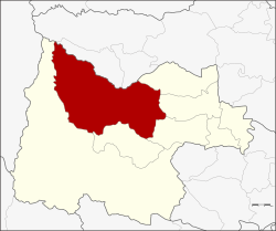
Lan Sak district
|
Lan Sak ลานสัก |
|
|---|---|
| Province: | Uthai Thani |
| Surface: | 1080.4 km² |
| Residents: | 57,548 (2005) |
| Population density : | 53.3 U / km² |
| ZIP : | 61160 |
| Geocode : | 6107 |
| map | |

|
|
Amphoe Lan Sak ( Thai อำเภอ ลานสัก ) is a district ( Amphoe - administrative district) in the north of the Uthai Thani Province . The Uthai Thani Province is located in the northern region of Thailand .
geography
Neighboring counties (clockwise from east): Amphoe Sawang Arom , Thap Than , Nong Chang , Huai Khot and Ban Rai in Uthai Thani Province, and Amphoe Mae Poen and Chum Ta Bong in Nakhon Sawan Province .
Important water resources in the district are the Huai Thap Salao reservoir and the Maenam Kha Khaeng ("KhaKhaeng River", also: "Huai Kha Khaeng").
history
The Tambon Lan Sak and Pradu Yuen of Amphoe Ban Rai were appointed to a new subdistrict ( King Amphoe ) on October 15, 1975 . The administration was in Ban Pak Muean. On July 13, 1981, Lan Sak was promoted to Amphoe. At the same time, the administration was moved to Ban Kao.
administration
Amphoe Lan Sak is divided into six communes ( tambon ) , which are further subdivided into 81 villages ( muban ) .
Lan Sak ( Thai เทศบาล ตำบล ลานสัก ) is also the name of a small town ( Thesaban Tambon ) in the district, which consists of parts of the Tambon Lan Sak and Pradu Yuen.
There are also six “Tambon Administrative Organizations” (TAO, องค์การ บริหาร ส่วน ตำบล - administrative organizations) in the district.
| No. | Name tambon | Thai | Muban | Pop. |
|---|---|---|---|---|
| 1. | Lan Sak | ลานสัก | 10 | 13,905 |
| 2. | Pradu Yuen | ประดู่ ยืน | 12 | 6,697 |
| 3. | Pa O | ป่า อ้อ | 10 | 7,358 |
| 4th | Rabam | ระบำ | 19th | 12,573 |
| 5. | Nam Rop | น้ำ รอบ | 18th | 9,635 |
| 6th | Thung Na Ngam | ทุ่ง นา งาม | 12 | 7,380 |
Web links
- More details about the Amphoe Lan Sak from amphoe.com (in Thai)
Individual evidence
- ↑ ประกาศ กระทรวง มหาดไทย เรื่อง แบ่ง ท้องที่ อำเภอ บ้านไร่ จังหวัด อุทัยธานี ตั้ง เป็น กิ่ง อำเภอ ลานสัก . In: Royal Gazette . tape 92 , 213 ง , October 14, 1975, pp. 2624 (Thai, soc.go.th [PDF]).
- ↑ พระราชกฤษฎีกา ตั้ง อำเภอ หนองใหญ่ อำเภอ บ่อไร่ อำเภอ พรหมคีรี อำเภอ นาบอน อำเภอ บางสะพาน น้อย อำเภอ นาดี อำเภอ กงหรา อำเภอ วังทรายพูน อำเภอ ธารโต อำเภอ คำตากล้า อำเภอ อำเภอ ศรีนคร อำเภอ ด่านช้าง อำเภอ พรเจริญ อำเภอ วังสามหมอ และ อำเภอ ลานสัก พ.ศ. ๒๕๒๔ . In: Royal Gazette . tape 98 , 115 ก ฉบับ พิเศษ (special), July 13, 1981, pp. 7–10 (Thai, soc.go.th [PDF]).
Coordinates: 15 ° 27 ' N , 99 ° 35' E