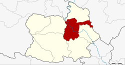
Amphoe Mueang Chai Nat
|
Mueang Chai Nat เมือง ชัยนาท |
|
|---|---|
| Province: | Chai Nat |
| Surface: | 255.377 km² |
| Residents: | 71,412 (2013) |
| Population density : | 286.6 U / km² |
| ZIP : | 17000, 17120 |
| Geocode : | 1801 |
| map | |

|
|
Amphoe Mueang Chai Nat ( Thai : อำเภอ เมือง ชัยนาท ) is a district ( amphoe - administrative district) in the province of Chai Nat . The Chai Nat Province is located in the central region of Thailand . The provincial capital Chai Nat is located in this district .
location
Chai Nat is located in the northern central region on the Mae Nam Chao Phraya (Chao Phraya River) . The city has always been a hub for goods of all kinds.
Neighboring districts are (from the east clockwise): Amphoe Sapphaya , Sankhaburi , Hankha , Wat Sing and Manorom the province of Chai Nat and Amphoe Takhli the province of Nakhon Sawan .
history
In 1917, the Mueang District was renamed Ban Kluai ( บ้าน กล้วย ). In 1938 the name was changed to Mueang Chai Nat .
administration
Provincial Administration
The district of Mueang Chai Nat is divided into nine tambon ("subdistricts" or "municipalities"), which are further divided into 75 muban ("villages").
| No. | Surname | Thai | Muban | Pop. |
|---|---|---|---|---|
| 1. | Nai Mueang | ใน เมือง | - | 4,895 |
| 2. | Ban Kluai | บ้าน กล้วย | - | 12,862 |
| 3. | Tha Chai | ท่า ชัย | 11 | 9,283 |
| 4th | Chai Nat | ชัยนาท | 9 | 8,176 |
| 5. | Khao Tha Phra | เขา ท่าพระ | 8th | 8,017 |
| 6th | Has Tha Sao | หาด ท่า เสา | 8th | 5.111 |
| 7th | Thammamun | ธร ร มา มูล | 10 | 7,578 |
| 8th. | Suea Hok | เสือ โฮก | 14th | 7,653 |
| 9. | Nang Lue | นาง ลือ | 15th | 7,837 |
Local administration
There is one commune with "city" status ( Thesaban Mueang ) in the district:
- Chai Nat (Thai: เทศบาล เมือง ชัยนาท ) consisting of the complete Tambon Nai Mueang and the parts of the Tambon Ban Kluai, Tha Chai, Khao Tha Phra.
There are six municipalities with "small town" status ( Thesaban Tambon ) in the district:
- Thammamun (Thai: เทศบาล ตำบล ธร ร มา มูล ) consisting of the complete tambon Thammamun.
- Ban Kluai (Thai: เทศบาล ตำบล บ้าน กล้วย ) consisting of parts of the tambon Ban Kluai.
- Chai Nat (Thai: เทศบาล ตำบล ชัยนาท ) consisting of the complete Tambon Chai Nat.
- Hat Tha Sao (Thai: เทศบาล ตำบล หาด ท่า เสา ) consisting of the complete tambon Hat Tha Sao.
- Suea Hok (Thai: เทศบาล ตำบล เสือ โฮก ) consisting of the complete tambon Suea Hok.
- Nang Lue (Thai: เทศบาล ตำบล นาง ลือ ) consisting of the complete Tambon Nang Lue.
There are also two " tambon administration organizations " ( องค์การ บริหาร ส่วน ตำบล - Tambon Administrative Organizations, TAO)
- Tha Chai (Thai: องค์การ บริหาร ส่วน ตำบล ท่า ชัย ) consisting of parts of the Tambon Tha Chai.
- Khao Tha Phra (Thai: องค์การ บริหาร ส่วน ตำบล เขา ท่าพระ ) consisting of parts of the Tambon Khao Tha Phra.
Individual evidence
- ↑ ประกาศ กระทรวง มหาดไทย เรื่อง เปลี่ยน ชื่อ อำเภอ . In: Royal Gazette . 34, No. 0 ก , April 29, 1917, pp. 40-68.
- ↑ พระราชกฤษฎีกา เปลี่ยน นาม จังหวัด และ อำเภอ บาง แห่ง พุทธศักราช ๒๔๘๑ . In: Royal Gazette . 55, No. 0 ก , November 14, 1938, pp. 658-666.
- ↑ 2013 population statistics ( Thai ) Department of Provincial Administration. Retrieved August 25, 2014.
Web links
Coordinates: 15 ° 11 ′ N , 100 ° 7 ′ E
