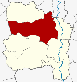
Pho Thong district
|
Pho Thong โพธิ์ทอง |
|
|---|---|
| Province: | Ang Thong |
| Surface: | 219.4 km² |
| Residents: | 54,159 (2013) |
| Population density : | 242.2 U / km² |
| ZIP : | 14120 |
| Geocode : | 1504 |
| map | |

|
|
Pho Thong District ( Thai อำเภอ โพธิ์ทอง ) is a district ( Amphoe - administrative district) of Ang Thong province . Ang Thong Province is located in the middle of the central region of Thailand .
geography
Neighboring districts are (from north clockwise): sawaeng ha district in the province of Ang Thong, Tha Chang and Phrom Buri District of Province Sing Buri , Amphoe Chaiyo , Mueang Ang Thong , Wiset Chai Chan and Samko in Ang Thong province, and finally Amphoe Si Prachan the province of Suphan Buri .
economy
The main product of Amphoe Pho Thong consists of basket weaving , which has even achieved a certain fame for its richness of detail and durability. A small village, Ban Bang Chao Cha, which specializes in the manufacture of wicker baskets from bamboo, received benevolent recognition during a visit from Princess Maha Chakri Sirindhorn . This is where the so-called Dok Phikun design was first developed. The marketing of the products is supported internationally by the OTOP organization ( One Tambon One Product ) .
history
The district was established in 1890, at that time it was called Huai Ling Tok. Later the name was changed to Pho Thong.
Attractions
- Wat Khun Inthapramun - The spacious Buddhist temple ( Wat ) , which dates from the Sukhothai period , is located a little off the main roads in the southeast of the district. The largest reclining Buddha statue in Thailand can be seen in this temple . The snow-white, 50 m long statue is now in the open air, only the floor plan of the former Wihan can be seen.
- Phra Tamnak Kham Yat ( พระ ตำหนัก คำ หยาด ) - ruin of the residence of King Uthumphon
administration
Provincial Administration
Pho Thong County is divided into 15 tambon ("subdistricts" or "communities"), which are further subdivided into 109 muban ("villages").
| No. | Surname | Thai | Muban | Pop. |
|---|---|---|---|---|
| 1. | Ang Kaeo | อ่าง แก้ว | 7th | 4,612 |
| 2. | Inthapramun | อิน ท ประมูล | 7th | 3,629 |
| 3. | Bang Phlap | บาง พลับ | 6th | 3,730 |
| 4th | Nong Mae Kai | หนอง แม่ ไก่ | 7th | 2.986 |
| 5. | Ram Masak | รำ มะ สัก | 12 | 8,345 |
| 6th | Bang Rakam | บางระกำ | 7th | 2,426 |
| 7th | Pho Rang Nok | โพธิ์ รังนก | 3 | 1,679 |
| 8th. | Ongkharak | องครักษ์ | 8th | 5,077 |
| 9. | Khok Phutsa | โคก พุทรา | 6th | 2,709 |
| 10. | Yang Chai | ยาง ช้า ย | 11 | 6,034 |
| 11. | Bo Rae | บ่อแร่ | 4th | 1,667 |
| 12. | Thang Phra | ทาง พระ | 8th | 2,709 |
| 13. | Sam Ngam | สามง่าม | 6th | 1.921 |
| 14th | Bang Chao Cha | บาง เจ้า ฉ่า | 8th | 3,347 |
| 15th | Kham Yat | คำ หยาด | 9 | 3,288 |
Local administration
There are five municipalities with "small town" status ( Thesaban Tambon ) in the district:
- Muang Khan (Thai: เทศบาล ตำบล ม่วง คัน ) consisting of parts of the Tambon Ram Masak.
- Khok Phutsa (Thai: เทศบาล ตำบล โคก พุทรา ) consisting of the complete tambon Khok Phutsa.
- Thang Phra (Thai: เทศบาล ตำบล ทาง พระ ) consisting of the complete Tambon Thang Phra.
- Pho Thong (Thai: เทศบาล ตำบล โพธิ์ทอง ) consisting of the parts of the Tambon Ang Kaeo, Inthapramun, Bang Phlap.
- Ram Masak (Thai: เทศบาล ตำบล รำ มะ สัก ) consisting of parts of the Tambon Ram Masak.
In addition, there are nine " tambon administration organizations " ( องค์การ บริหาร ส่วน ตำบล - Tambon Administrative Organizations, TAO)
- Ang Kaeo (Thai: องค์การ บริหาร ส่วน ตำบล อ่าง แก้ว ) consisting of the complete tambon Bo Rae, Sam Ngam and parts of the tambon Ang Kaeo.
- Inthapramun (Thai: องค์การ บริหาร ส่วน ตำบล อิน ท ประมูล ) consisting of parts of the tambon Inthapramun.
- Bang Phlap (Thai: องค์การ บริหาร ส่วน ตำบล บาง พลับ ) consisting of the complete Tambon Pho Rang Nok and parts of the Tambon Bang Phlap.
- Nong Mae Kai (Thai: องค์การ บริหาร ส่วน ตำบล หนอง แม่ ไก่ ) consisting of the complete tambon Nong Mae Kai.
- Bang Rakam (Thai: องค์การ บริหาร ส่วน ตำบล บางระกำ ) consisting of the complete Tambon Bang Rakam.
- Ongkharak (Thai: องค์การ บริหาร ส่วน ตำบล องครักษ์ ) consisting of the complete tambon Ongkharak.
- Yang Chai (Thai: องค์การ บริหาร ส่วน ตำบล ยาง ช้า ย ) consisting of the complete Tambon Yang Chai.
- Bang Chao Cha (Thai: องค์การ บริหาร ส่วน ตำบล บาง เจ้า ฉ่า ) consisting of the complete tambon Bang Chao Cha.
- Kham Yat (Thai: องค์การ บริหาร ส่วน ตำบล คำ หยาด ) consisting of the complete Tambon Kham Yat.
Individual evidence
- ↑ 2013 population statistics ( Thai ) Department of Provincial Administration. Retrieved August 10, 2014.
Web links
- More information on Amphoe Pho Thong from amphoe.com (in Thai)
- Example of a wickerwork handbag from Pho Thong awarded by OTOP (in English)
Coordinates: 14 ° 40 ′ N , 100 ° 24 ′ E


