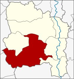
Wiset Chai Chan district
|
Wiset Chai Chan วิเศษชัยชาญ |
|
|---|---|
| Province: | Ang Thong |
| Surface: | 224.7 km² |
| Residents: | 67,046 (2013) |
| Population density : | 290.6 U / km² |
| ZIP : | 14110 |
| Geocode : | 1506 |
| map | |

|
|
Amphoe Wiset Chai Chan ( Thai : อำเภอ วิเศษชัยชาญ ) is a district ( Amphoe - administrative district) in the south-western part of Ang Thong Province . Ang Thong Province is located in the middle of the central region of Thailand .
geography
Neighboring districts are (from north clockwise): Amphoe Samko , Pho Thong , Mueang Ang Thong and Pa Mok in Ang Thong province, Phak Hai District of Ayutthaya Province , and Amphoe Mueang Suphan Buri and Si Prachan the province of Suphan Buri .
history
After King Naresuan the Great had defeated the Burmese army near Don Chedi , he led his troops through what is now Tambon Phai Cham Sin . He noted the strategic advantage that the Noi River presented as a natural barrier to Burmese forces. Therefore he founded the Mueang Wiset Chai Chan here.
Later, in the Rattanakosin period, the Noi River silted up more and more so that it was finally too shallow for water transport. The central tambon of the Mueang was assigned by the government of that time to Bang Kaeo and called Ang Thong . At the same time, the district was downgraded to Tambon Phai Cham Sin . King Chulalongkorn (Rama V) finally ordered that the district be renamed back to its historical name Wiset Chai Chan . In 1979 the administrative building of the district on the connecting road from Pho Phraya ( Province Suphan Buri ) to Tha Ruea ( Province Saraburi ) in Tambon San Chao Rong Thong was rebuilt.
Attractions
- Wat Muang (Thai: วัด ม่วง ) - a Buddhist temple ( Wat ) with a 92 meter high seated Buddha statue .
administration
Provincial Administration
Wiset Chai Chan County is divided into 15 tambon ("subdistricts" or "parishes"), which are further subdivided into 126 muban ("villages").
| No. | Surname | Thai | Muban | Pop. |
|---|---|---|---|---|
| 1. | Phai Cham Sin | ไผ่ จำ ศิ ล | 8th | 5,346 |
| 2. | San Chao Rong Thong | ศาล เจ้า โรง ทอง | 12 | 8,095 |
| 3. | Phai Dam Phatthana | ไผ่ ดำ พัฒนา | 8th | 3,316 |
| 4th | Sao Rong Hai | สาว ร้องไห้ | 8th | 4,472 |
| 5. | Tha Chang | ท่าช้าง | 6th | 3,935 |
| 6th | Yi Lon | ยี่ ล้น | 9 | 4,285 |
| 7th | Bang Chak | บาง จัก | 14th | 6,745 |
| 8th. | Huai Khan Laen | ห้วย คัน แหล น | 6th | 3,429 |
| 9. | Khlong Khanak | คลอง ขนาก | 9 | 3,971 |
| 10. | Phai Wong | ไผ่ วง | 7th | 3,522 |
| 11. | Si Roi | สี่ ร้อย | 7th | 3,532 |
| 12. | Muang Tia | ม่วง เตี้ย | 12 | 5,822 |
| 13. | Hua Taphan | หัวตะพาน | 7th | 3,001 |
| 14th | Lak Kaeo | หลัก แก้ว | 8th | 5,366 |
| 15th | Talat May | ตลาด ใหม่ | 5 | 2,209 |
Local administration
There are seven municipalities with "small town" status ( Thesaban Tambon ) in the district:
- Phai Dam Phatthana (Thai: เทศบาล ตำบล ไผ่ ดำ พัฒนา ) consisting of the complete tambon Phai Dam Phatthana.
- Sao Rong Hai (Thai: เทศบาล ตำบล สาว ร้องไห้ ) consisting of the complete tambon Sao Rong Hai.
- Tha Chang (Thai: เทศบาล ตำบล ท่าช้าง ) consisting of the complete Tambon Tha Chang and parts of the Tambon Si Roi.
- Huai Khan Laen (Thai: เทศบาล ตำบล ห้วย คัน แหล น ) consisting of the complete tambon Huai Khan Laen.
- Muang Tia (Thai: เทศบาล ตำบล ม่วง เตี้ย ) consisting of the complete Tambon Muang Tia.
- Bang Chak (Thai: เทศบาล ตำบล บาง จัก ) consisting of the parts of the Tambon Bang Chak, Khlong Khanak, Si Roi.
- Wiset Chai Chan (Thai: เทศบาล ตำบล วิเศษ ไชย ชาญ ) consisting of the parts of the Tambon Phai Cham Sin, San Chao Rong Thong.
In addition, there are nine " tambon administration organizations " ( องค์การ บริหาร ส่วน ตำบล - Tambon Administrative Organizations, TAO)
- Phai Cham Sin (Thai: องค์การ บริหาร ส่วน ตำบล ไผ่ จำ ศิ ล ) consisting of parts of the Tambon Phai Cham Sin.
- San Chao Rong Thong (Thai: องค์การ บริหาร ส่วน ตำบล ศาล เจ้า โรง ทอง ) consisting of parts of the Tambon San Chao Rong Thong.
- Yi Lon (Thai: องค์การ บริหาร ส่วน ตำบล ยี่ ล้น ) consisting of the complete tambon Yi Lon.
- Bang Chak (Thai: องค์การ บริหาร ส่วน ตำบล บาง จัก ) consisting of parts of the Tambon Bang Chak.
- Khlong Khanak (Thai: องค์การ บริหารส่วน ตำบล คลอง ขนาก ) consisting of parts of the Tambon Khlong Khanak.
- Phai Wong (Thai: องค์การ บริหาร ส่วน ตำบล ไผ่ วง ) consisting of the complete tambon Phai Wong.
- Hua Taphan (Thai: องค์การ บริหาร ส่วน ตำบล หัวตะพาน ) consisting of the complete Tambon Hua Taphan.
- Lak Kaeo (Thai: องค์การ บริหาร ส่วน ตำบล หลัก แก้ว ) consisting of the complete Tambon Lak Kaeo.
- Talat Mai (Thai: องค์การ บริหาร ส่วน ตำบล ตลาด ใหม่ ) consisting of the complete Tambon Talat Mai.
Individual evidence
- ↑ 2013 population statistics ( Thai ) Department of Provincial Administration. Retrieved August 10, 2014.
Web links
- More details on Amphoe Wiset Chai Chan from amphoe.com (in Thai)
- Wat Muang website (in Thai)
Coordinates: 14 ° 36 ' N , 100 ° 20' E

