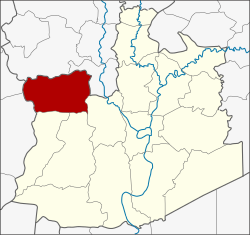
Amphoe Phak Hai
|
Phak Hai ผักไห่ |
|
|---|---|
| Province: | Ayutthaya |
| Surface: | 189.0 km² |
| Residents: | 41,927 (2013) |
| Population density : | 235.1 U / km² |
| ZIP : | 13120, 13280 |
| Geocode : | 1408 |
| map | |

|
|
Amphoe Phak Hai ( Thai : อำเภอ ผักไห่ , pronunciation: ʔāmpʰɤ̄ː pʰàk hàj ) is a district ( Amphoe - administrative district) in the north-western part of Ayutthaya Province ("Phra Nakhon Si Ayutthaya Province"). Ayutthaya Province is located in the central region of Thailand .
etymology
The name Phak Hai probably comes from a Nirat poetry by the Thai national poet Sunthorn Phu , who mentions a village called Ban Pak Hai. However, the Thai spelling was later changed so that it is now named after a type of grass that grows in swamps.
geography
Neighboring counties are (clockwise from the north): Amphoe Wiset Chai Chan and Pa Mok of Ang Thong Province , Amphoe Bang Ban , Sena and Bang Sai of Ayutthaya Province, and Amphoe Bang Pla Ma and Mueang Suphan Buri of Suphan Buri Province .
history
In the past this county was called Khwaeng Sena Yai. It was converted into an amphoe towards the end of the 19th century . In 1917 the district was renamed after the name of the central tambon Phak Hai.
Administrative division
Provincial Administration
Phak Hai County is divided into 16 tambon ("subdistricts" or "communities"), which are further subdivided into 128 muban ("villages").
| No. | Surname | Thai | Muban | Pop. |
|---|---|---|---|---|
| 1. | Phak Hai | ผักไห่ | 12 | 4,429 |
| 2. | Ammarit | อมฤต | 11 | 2,039 |
| 3. | Ban Khae | บ้าน แค | 8th | 3,344 |
| 4th | Lat Nam Khem | ลาด น้ำเค็ม | 6th | 2,287 |
| 5. | Talan | ตาลาน | 7th | 1,861 |
| 6th | Tha Din Daeng | ท่าดินแดง | 8th | 2.010 |
| 7th | Don Lan | ดอน ลาน | 6th | 2,185 |
| 8th. | Well Khu | นา คู | 8th | 2,197 |
| 9. | Kudi | กุฎี | 12 | 2,384 |
| 10. | Lam Takhian | ลำ ตะเคียน | 5 | 1,241 |
| 11. | Khok Chang | โคก ช้าง | 5 | 1,641 |
| 12. | Chakkarat | จักราช | 6th | 2.148 |
| 13. | Nong Nam Yai | หนอง น้ำ ใหญ่ | 11 | 5,999 |
| 14th | Lat chit | ลาด ชิด | 10 | 3,669 |
| 15th | Well khok | หน้า โคก | 7th | 2,309 |
| 16. | Ban Yai | บ้าน ใหญ่ | 6th | 2.184 |
Local administration
There is one commune with "city" status ( Thesaban Mueang ) in the district:
- Phak Hai (Thai: เทศบาล เมือง ผักไห่ ) consisting of the complete Tambon Ammarit, Ban Yai and the parts of the Tambon Phak Hai, Talan, Lat Chit, Na Khok.
There is one municipality with "small town" status ( Thesaban Tambon ) in the district:
- Lat Chado (Thai: เทศบาล ตำบล ลาด ชะโด ) consisting of the complete Tambon Chakkarat, Nong Nam Yai.
In addition, there are eight " tambon administration organizations " ( องค์การ บริหาร ส่วน ตำบล - Tambon Administrative Organizations, TAO)
- Ban Khae (Thai: องค์การ บริหาร ส่วน ตำบล บ้าน แค ) consisting of the complete tambon Ban Khae.
- Lat Nam Khem (Thai: องค์การ บริหาร ส่วน ตำบล ลาด น้ำเค็ม ) consisting of the complete tambon Lat Nam Khem, Khok Chang and parts of the Tambon Phak Hai.
- Tha Din Daeng (Thai: องค์การ บริหาร ส่วน ตำบล ท่าดินแดง ) consisting of the complete tambon Tha Din Daeng.
- Don Lan (Thai: องค์การ บริหาร ส่วน ตำบล ดอน ลาน ) consisting of the complete tambon Don Lan, Lam Takhian.
- Na Khu (Thai: องค์การ บริหาร ส่วน ตำบล นา คู ) consisting of the complete Tambon Na Khu.
- Kudi (Thai: องค์การ บริหาร ส่วน ตำบล กุฎี ) consisting of the complete tambon Kudi.
- Lat Chit (Thai: องค์การ บริหาร ส่วน ตำบล ลาด ชิด ) consisting of the parts of the Tambon Talan, Lat Chit.
- Na Khok (Thai: องค์การ บริหาร ส่วน ตำบล หน้า โคก ) consisting of parts of the Tambon Na Khok.
Individual evidence
- ↑ 2013 population statistics ( Thai ) Department of Provincial Administration. Retrieved August 24, 2014.
Web links
Coordinates: 14 ° 27 ' N , 100 ° 22' E
