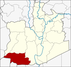
Lat Bua Luang district
|
Lat Bua Luang ลาดบัวหลวง |
|
|---|---|
| Province: | Ayutthaya |
| Surface: | 199.9 km² |
| Residents: | 38,619 (2013) |
| Population density : | 181.0 U / km² |
| ZIP : | 13230 |
| Geocode : | 1410 |
| map | |

|
|
Amphoe Lat Bua Luang ( Thai : ลาดบัวหลวง , pronunciation: ʔāmpʰɤ̄ː lâːt būa lǔaŋ ) is a district ( Amphoe - administrative district) in the southern part of Ayutthaya Province ("Phra Nakhon Si Ayutthaya Province"). Ayutthaya Province is located in the central region of Thailand .
geography
Neighboring districts are (from north clockwise): Amphoe Bang Sai ( บางซ้าย ) , Sena and Bang Sai ( บางไทร ) Ayutthaya Province, Amphoe Sam Khok and Lat Lum Kaeo the province of Pathum Thani , Amphoe Sai Noi the province of Nonthaburi , Amphoe Bang Len the province of Nakhon Pathom and Amphoe song Phi Nong of Suphan Buri Province .
history
Lat Bua Luang was officially established as an Amphoe in 1947 when Tambon Lat Bua Luang was separated from Bang Sai Amphoe .
Administrative division
Provincial Administration
The district of Lat Bua Luang is divided into seven tambon ("subdistricts" or "municipalities"), which are further subdivided into 58 muban ("villages").
| No. | Surname | Thai | Muban | Pop. |
|---|---|---|---|---|
| 1. | Lat Bua Luang | ลาดบัวหลวง | 9 | 7,749 |
| 2. | Lak chai | หลักชัย | 10 | 5,417 |
| 3. | Sam Mueang | สาม เมือง | 8th | 6,802 |
| 4th | Phraya Banlue | พระยา บันลือ | 7th | 6.115 |
| 5. | Singhanat | สิงหนาท | 7th | 3,250 |
| 6th | Khu Salot | คู้ สลอด | 10 | 5,097 |
| 7th | Khlong Phraya Banlue | คลอง พระยา บันลือ | 7th | 4.189 |
Local administration
There are two municipalities with "small town" status ( Thesaban Tambon ) in the district:
- Lat Bua Luang (Thai: เทศบาล ตำบล ลาดบัวหลวง ) consisting of parts of the tambon Lat Bua Luang.
- Sam Mueang (Thai: เทศบาล ตำบล สาม เมือง ) consisting of the complete Tambon Sam Mueang.
In addition, there are six " tambon administration organizations " ( องค์การ บริหาร ส่วน ตำบล - Tambon Administrative Organizations, TAO)
- Lat Bua Luang (Thai: องค์การ บริหาร ส่วน ตำบล ลาดบัวหลวง ) consisting of parts of the tambon Lat Bua Luang.
- Lak Chai (Thai: องค์การ บริหาร ส่วน ตำบล หลักชัย ) consisting of the complete Tambon Lak Chai.
- Phraya Banlue (Thai: องค์การ บริหารส่วน ตำบล พระยา บันลือ ) consisting of the complete Tambon Phraya Banlue.
- Singhanat (Thai: องค์การ บริหาร ส่วน ตำบล สิงหนาท ) consisting of the complete Tambon Singhanat.
- Khu Salot (Thai: องค์การ บริหาร ส่วน ตำบล คู้ สลอด ) consisting of the complete Tambon Khu Salot.
- Khlong Phraya Banlue (Thai: องค์การ บริหารส่วน ตำบล คลอง พระยา บันลือ ) consisting of the complete tambon Khlong Phraya Banlue.
Individual evidence
- ↑ 2013 population statistics ( Thai ) Department of Provincial Administration. Retrieved August 12, 2014.
Web links
Coordinates: 14 ° 10 ' N , 100 ° 18' E
