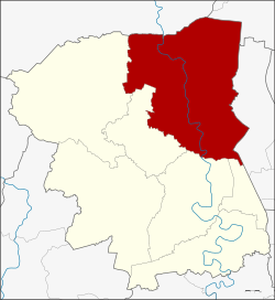
Bang Len district
|
Bang Len บางเลน |
|
|---|---|
| Province: | Nakhon Pathom |
| Surface: | 588.8 km² |
| Residents: | 91,945 (2013) |
| Population density : | 156 U / km² |
| ZIP : | 73130, 73190 |
| Geocode : | 7305 |
| map | |

|
|
Amphoe Bang Len ( Thai : อำเภอ บางเลน , pronunciation: ʔāmpʰɤ̄ː bāːŋ lēːn ) is a district ( Amphoe - administrative district) in the northeastern part of the Nakhon Pathom Province . The Nakhon Pathom Province is located in the middle of the central region of Thailand .
geography
The neighboring districts are clockwise from the north: Song Phi Nong district of Suphan Buri province , Lat Bua Luang district of Ayutthaya province , Sai Noi district of Nonthaburi province, and Phutthamonthon district , Nakhon Chai Si , Don Tum and Kamphaeng Saen of Nakhon province Pathoma.
The main water resource of the county is the Mae Nam Tha Chin (Tha Chin River), which is called "Mae Nam Nakhon Chai Si" throughout the province.
history
The county was established in 1896 under the name Bang Phai Nat ( บางไผ่ นา รถ ). The administration building was in Ban Bang Phai Nat in Tambon Bang Sai Pa on the eastern bank of Maenam Nakhon Chai Si. Later the middle district was moved to Tambon Bang Pla on the west bank of the Tha Chin, at the same time the name was changed to Bang Pla. In 1936 the district was given its current name Bang Len. The administration building was only moved to Phon Damri Road in Tambon Bang Len in 1978.
administration
Provincial Administration
Bang Len County is divided into 15 tambon ("subdistricts" or "parishes"), which are further subdivided into 167 Muban ("villages").
| No. | Surname | Thai | Muban | Pop. |
|---|---|---|---|---|
| 1. | Bang Len | บางเลน | 12 | 11,952 |
| 2. | Bang Pla | บาง ปลา | 15th | 7.094 |
| 3. | Bang Luang | บาง หลวง | 21st | 9,656 |
| 4th | Bang Phasi | บาง ภาษี | - | 9,377 |
| 5. | Bang Rakam | บางระกำ | 15th | 4,731 |
| 6th | Bang Sai Pa | บางไทร ป่า | 10 | 6,053 |
| 7th | Hin Mun | หิน มูล | 12 | 6.013 |
| 8th. | Sai Ngam | ไทรงาม | 11 | 5,195 |
| 9. | Don Tum | ดอนตูม | 11 | 4,956 |
| 10. | Ninlaphet | นิล เพชร | 10 | 4,716 |
| 11. | Bua Pak Tha | บัว ปาก ท่า | 10 | 4,493 |
| 12. | Khlong Nok Krathung | คลอง นกกระทุง | 11 | 3,705 |
| 13. | Naraphiroma | นรา ภิรมย์ | 11 | 5,058 |
| 14th | Lam Phaya | ลำ พญา | 11 | 4,572 |
| 15th | Phai Hu Chang | ไผ่ หูช้าง | 7th | 4,374 |
Local administration
There are view municipalities with "small town" status ( Thesaban Tambon ) in the district:
- Bang Len (Thai: เทศบาล ตำบล บางเลน ) consisting of the parts of the tambon Bang Len, Bang Sai Pa.
- Bang Luang (Thai: เทศบาล ตำบล บาง หลวง ) consisting of parts of the Tambon Bang Luang.
- Rank Krathum (Thai: เทศบาล ตำบล ราง กระทุ่ม ) consisting of parts of the Tambon Bang Phasi.
- Lam Phaya (Thai: เทศบาล ตำบล ลำ พญา ) consisting of parts of the Tambon Lam Phaya.
There are also 15 " tambon administration organizations " ( องค์การ บริหาร ส่วน ตำบล - Tambon Administrative Organizations, TAO)
- Bang Len (Thai: องค์การ บริหาร ส่วน ตำบล บางเลน ) consisting of parts of the tambon Bang Len.
- Bang Pla (Thai: องค์การ บริหาร ส่วน ตำบล บาง ปลา ) consisting of the complete Tambon Bang Pla.
- Bang Luang (Thai: องค์การ บริหาร ส่วน ตำบล บาง หลวง ) consisting of parts of the Tambon Bang Luang.
- Bang Phasi (Thai: องค์การ บริหาร ส่วน ตำบล บาง ภาษี ) consisting of parts of the Tambon Bang Phasi.
- Bang Rakam (Thai: องค์การ บริหาร ส่วน ตำบล บางระกำ ) consisting of the complete Tambon Bang Rakam.
- Bang Sai Pa (Thai: องค์การ บริหาร ส่วน ตำบล บางไทร ป่า ) consisting of parts of the Tambon Bang Sai Pa.
- Hin Mun (Thai: องค์การ บริหาร ส่วน ตำบล หิน มูล ) consisting of the complete tambon Hin Mun.
- Sai Ngam (Thai: องค์การ บริหาร ส่วน ตำบล ไทรงาม ) consisting of the complete tambon Sai Ngam.
- Don Tum (Thai: องค์การ บริหาร ส่วน ตำบล ดอนตูม ) consisting of the complete tambon Don Tum.
- Nin Phet (Thai: องค์การ บริหาร ส่วน ตำบล นิล เพชร ) consisting of the complete tambon Nin Phet.
- Bua Pak Tha (Thai: องค์การ บริหาร ส่วน ตำบล บัว ปาก ท่า ) consisting of the complete tambon Bua Pak Tha.
- Khlong Nok Krathung (Thai: องค์การ บริหารส่วน ตำบล คลอง นกกระทุง ) consisting of the complete tambon Khlong Nok Krathung.
- Naraphirom (Thai: องค์การ บริหาร ส่วน ตำบล นรา ภิรมย์ ) consisting of the complete tambon Naraphirom.
- Lam Phaya (Thai: องค์การ บริหาร ส่วน ตำบล ลำ พญา ) consisting of parts of the Tambon Lam Phaya.
- Phai Hu Chang (Thai: องค์การ บริหาร ส่วน ตำบล ไผ่ หูช้าง ) consisting of the complete tambon Phai Hu Chang.
Individual evidence
- ↑ 2013 population statistics ( Thai ) Department of Provincial Administration. Retrieved August 9, 2014.
Web links
- More information on Amphoe Bang Len from amphoe.com (in Thai). Archived from the original on September 18, 2010 ; Retrieved July 29, 2015 .
Coordinates: 14 ° 1 ′ N , 100 ° 10 ′ E
