Song Phi Nong district
|
Song Phi Nong สองพี่น้อง |
|
|---|---|
| Province: | Suphan Buri |
| Surface: | 750.381 km² |
| Residents: | 127,411 (2013) |
| Population density : | 169.12 E./km² |
| ZIP : | 72110, 72190, 71170, 72170 |
| Geocode : | 7207 |
| map | |

|
|
Amphoe Song Phi Nong ( Thai : อำเภอ สองพี่น้อง , pronunciation: ʔāmpʰɤ̄ː sɔ̌ːŋ pʰîː nɔ́ːŋ ) is the southernmost district ( Amphoe - administrative district) of Suphan Buri Province . The province of Suphan Buri is located in the western part of the central region of Thailand .
geography
The neighboring Amphoe are clockwise from the north: Amphoe U Thong and Bang Pla Ma of Suphan Buri Province, Lat Bua Luang of Ayutthaya Province , Bang Len and Kamphaeng Saen of Nakhon Pathom Province, and Amphoe Tha Maka and Phanom Thuan of Kanchanaburi Province .
history
The district was founded in 1896. It was previously part of the U Thong District .
Song Phi Nong's main water resource is the Mae Nam Tha Chin (Tha Chin River), also known as the Mae Nam Suphan (Suphan River).
Attractions
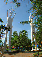
- Wat Phai Rong Wua ( วัด ไผ่ โรง วัว ), bizarre temple district ( Wat ) on a huge site. For example, a replica of the Mahabodhi temple (the original is in Bodhgaya , India), numerous, partly larger than life- size Buddha statues and a sculpture "garden" with detailed depictions of residents ( hungry ghosts ) of the various Buddhist hells during the Visitors are showered with mystical music from omnipresent speakers.
administration
Provincial Administration
Song Phi Nong County is divided into 15 tambon ("subdistricts" or "parishes"), which are further divided into 140 muban ("villages").
| No. | Surname | Thai | Muban | Pop. |
|---|---|---|---|---|
| 1. | Song Phi Nong | สองพี่น้อง | - | 12,894 |
| 2. | Bang Len | บางเลน | 7th | 7,099 |
| 3. | Bang Ta Then | บางตา เถร | 18th | 15,443 |
| 4th | Bang Takhian | บาง ตะเคียน | 8th | 5,634 |
| 5. | Ban Cum | บ้าน กุ่ม | 6th | 3,488 |
| 6th | Hua Pho | หัว โพธิ์ | 14th | 9,994 |
| 7th | Bang Phlap | บาง พลับ | 7th | 5.116 |
| 8th. | Noen Phra Prang | เนิน พระ ปรางค์ | 5 | 4,428 |
| 9. | Ban Chang | บ้าน ช้าง | 5 | 3.159 |
| 10. | Tone tan | ต้นตาล | 6th | 3,350 |
| 11. | Si Samran | ศรี สำราญ | 14th | 11.199 |
| 12. | Thung Khok | ทุ่ง คอก | 16 | 16,103 |
| 13. | Nong Bo | หนอง บ่อ | 9 | 5,333 |
| 14th | Bo Suphan | บ่อ สุพรรณ | 18th | 19,031 |
| 15th | Don Manao | ดอน มะนาว | 7th | 5,140 |
Local administration
There is one commune with "city" status ( Thesaban Mueang ) in the district:
- Song Phi Nong (Thai: เทศบาล เมือง สองพี่น้อง ) consisting of the complete tambon Song Phi Nong.
There is one municipality with "small town" status ( Thesaban Tambon ) in the district:
- Thung Khok (Thai: เทศบาล ตำบล ทุ่ง คอก ) consisting of parts of the tambon Thung Khok.
There are also 14 " tambon administration organizations " ( องค์การ บริหาร ส่วน ตำบล - Tambon Administrative Organizations, TAO)
- Bang Len (Thai: องค์การ บริหาร ส่วน ตำบล บางเลน ) consisting of the complete tambon Bang Len.
- Bang Ta Then (Thai: องค์การ บริหาร ส่วน ตำบล บางตา เถร ) consisting of the complete tambon Bang Ta Then.
- Bang Takhian (Thai: องค์การ บริหาร ส่วน ตำบล บาง ตะเคียน ) consisting of the complete tambon Bang Takhian.
- Ban Kum (Thai: องค์การ บริหาร ส่วน ตำบล บ้าน กุ่ม ) consisting of the complete Tambon Ban Kum.
- Hua Pho (Thai: องค์การ บริหาร ส่วน ตำบล หัว โพธิ์ ) consisting of the complete Tambon Hua Pho.
- Bang Phlap (Thai: องค์การ บริหาร ส่วน ตำบล บาง พลับ ) consisting of the complete Tambon Bang Phlap.
- Noen Phra Prang (Thai: องค์การ บริหาร ส่วน ตำบล เนิน พระ ปรางค์ ) consisting of the complete tambon Noen Phra Prang.
- Ban Chang (Thai: องค์การ บริหาร ส่วน ตำบล บ้าน ช้าง ) consisting of the complete Tambon Ban Chang.
- Ton Tan (Thai: องค์การ บริหาร ส่วน ตำบล ต้นตาล ) consisting of the complete tambon Ton Tan.
- Si Samran (Thai: องค์การ บริหาร ส่วน ตำบล ศรี สำราญ ) consisting of the complete tambon Si Samran.
- Thung Khok (Thai: องค์การ บริหาร ส่วน ตำบล ทุ่ง คอก ) consisting of parts of the tambon Thung Khok.
- Nong Bo (Thai: องค์การ บริหาร ส่วน ตำบล หนอง บ่อ ) consisting of the complete Tambon Nong Bo.
- Bo Suphan (Thai: องค์การ บริหาร ส่วน ตำบล บ่อ สุพรรณ ) consisting of the complete tambon Bo Suphan.
- Don Manao (Thai: องค์การ บริหาร ส่วน ตำบล ดอน มะนาว ) consisting of the complete tambon Don Manao.
Individual evidence
- ↑ มา รู้จัก อำเภอ กัน เถอะ อำเภอ สองพี่น้อง จังหวัด สุพรรณบุรี (in Thai)
- ↑ 2013 population statistics ( Thai ) Department of Provincial Administration. Retrieved September 20, 2014.
Web links
Coordinates: 14 ° 13 ' N , 100 ° 1' E

