U Thong district
|
U thong อู่ทอง |
|
|---|---|
| Province: | Suphan Buri |
| Surface: | 630.29 km² |
| Residents: | 121,421 (2013) |
| Population density : | 177.2 U / km² |
| ZIP : | 72160, 72220, 71170 |
| Geocode : | 7209 |
| map | |

|
|

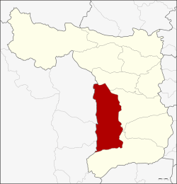
Amphoe U Thong ( Thai : อำเภอ อู่ทอง , pronunciation: ʔāmpʰɤ̄ː ʔùː tʰɔ̄ːŋ , roughly: Golden Cradle ) is a district ( Amphoe - administrative district) in the west of the province of Suphan Buri . The province of Suphan Buri is located in the western part of the central region of Thailand .
geography
The neighboring amphoe is clockwise from the north: Don Chedi , Mueang Suphan Buri , Bang Pla Ma and Song Phi Nong , and the amphoe of Kanchanaburi Province : Nong Prue , Lao Khwan , Huai Krachao and Phanom Thuan .
history
U Thong is a very old city. Archaeologists found prehistoric tools and human skeletons in many parts of the county. It is believed that this was a center of the Dvaravati culture.
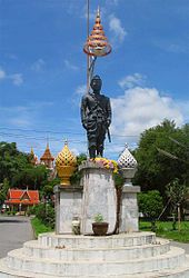
Mueang Thao U Thong ("the city of King U Thong ") is also a city from the legends surrounding the foundation of the Ayutthaya kingdom . Prince U Thong is said to have brought the inhabitants of his city to safety from a cholera epidemic, and so not very far away founded the new city of Krung Si Ayutthaya on March 4, 1351 AD .
U Thong County was established in 1905 under the name Chorakhe Sam Phan. In 1940, the government moved the administration of the Ban Chorakhe Sam Phan District to the historic city area. At the same time the name was changed to U Thong.
Products
About 200 years ago a group of emigrants from Vientiane , Laos settled in Ban Kham in what is now Tambon Phlapphla Chai. The old knowledge about medicinal herbs was passed on from generation to generation and has now been developed to a certain degree of perfection within the framework of the OTOP ( One Tambon One Product ) .
Attractions
- The U-Thong National Museum has numerous finds excavated here by archaeologists. For example, tools and Buddha statues are exhibited , some of which come from the Dvaravati period.
- Wat Khao Phra Sri Sanphet , a picturesquely situated Buddhist temple complex ( wat ) on a mountain with a large reclining Buddha statue in a cave
administration
Provincial Administration
U Thong County is divided into 13 tambon ("subdistricts" or "parishes"), which are further subdivided into 154 muban ("villages").
| No. | Surname | Thai | Muban | Pop. |
|---|---|---|---|---|
| 1. | U thong | อู่ทอง | 11 | 23,868 |
| 2. | Sa Yai Som | สระ ยาย โสม | 10 | 8,352 |
| 3. | Chorakhe Sam Phan | จร เข้ สาม พัน | 15th | 13,105 |
| 4th | Ban Don | บ้าน ดอน | 9 | 7,710 |
| 5. | Yung Thalai | ยุ้ง ทะลาย | 7th | 4,497 |
| 6th | Don Makluea | ดอน มะเกลือ | 12 | 4,548 |
| 7th | Nong Ong | หนอง โอ่ง | 14th | 9,859 |
| 8th. | Don Kha | ดอน คา | 20th | 13,245 |
| 9. | Phlapphla Chai | พลับพลาไชย | 14th | 11,854 |
| 10. | Ban Khong | บ้าน โข้ ง | 14th | 8,855 |
| 11. | Chedi | เจดีย์ | 8th | 3,076 |
| 12. | Sa Phang Lan | สระ พัง ลาน | 10 | 5,203 |
| 13. | Krachan | กระ จัน | 10 | 7,249 |
Local administration
There are nine municipalities with "small town" status ( Thesaban Tambon ) in the district:
- Chorakhe Sam Phan (Thai: เทศบาล ตำบล จร เข้ สาม พัน ) consisting of the complete tambon Chorakhe Sam Phan.
- Chedi (Thai: เทศบาล ตำบล เจดีย์ ) consisting of the complete Tambon Chedi.
- Sa Yai Som (Thai: เทศบาล ตำบล สระ ยาย โสม ) consisting of parts of the tambon Sa Yai Som.
- U Thong (Thai: เทศบาล ตำบล อู่ทอง ) consisting of parts of the Tambon U Thong.
- Khun Phat Pheng (Thai: เทศบาล ตำบล ขุน พัด เพ็ง ) consisting of parts of the tambon Sa Yai Som.
- Ban Don (Thai: เทศบาล ตำบล บ้าน ดอน ) consisting of the complete tambon Ban Don.
- Ban Khong (Thai: เทศบาล ตำบล บ้าน โข้ ง ) consisting of the complete tambon Ban Khong.
- Krachan (Thai: เทศบาล ตำบล กระ จัน ) consisting of the complete Tambon Krachan.
- Thao U Thong (Thai: เทศบาล ตำบล ท้าว อู่ทอง ) consisting of parts of the Tambon U Thong.
In addition, there are six " tambon administration organizations " ( องค์การ บริหาร ส่วน ตำบล - Tambon Administrative Organizations, TAO)
- Yung Thalai (Thai: องค์การ บริหาร ส่วน ตำบล ยุ้ง ทะลาย ) consisting of the complete tambon Yung Thalai.
- Don Makluea (Thai: องค์การ บริหารส่วน ตำบล ดอน มะเกลือ ) consisting of the complete tambon Don Makluea.
- Nong Ong (Thai: องค์การ บริหาร ส่วน ตำบล หนอง โอ่ง ) consisting of the complete Tambon Nong Ong.
- Don Kha (Thai: องค์การ บริหาร ส่วน ตำบล ดอน คา ) consisting of the complete tambon Don Kha.
- Phlapphla Chai (Thai: องค์การ บริหาร ส่วน ตำบล พลับพลาไชย ) consisting of the complete tambon Phlapphla Chai.
- Sa Phang Lan (Thai: องค์การ บริหาร ส่วน ตำบล สระ พัง ลาน ) consisting of the complete Sa Phang Lan tambon.
Individual evidence
- ↑ พระราชกฤษฎีกา เปลี่ยน นาม อำเภอ กิ่ง อำเภอ และ ตำบล บาง แห่ง พุทธศักราช ๒๔๘๒ . In: Royal Gazette . tape 56 , 0 ก , April 17, 1939, p. 354-364 (Thai, soc.go.th [PDF]).
- ↑ 2013 Population Statistics . Department of Provincial Administration, accessed October 4, 2014 (Thai).
Web links
Coordinates: 14 ° 23 ' N , 99 ° 54' E


