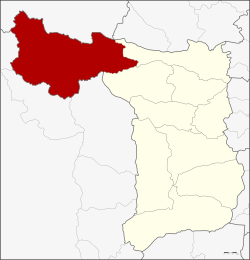
Dan Chang District
|
Dan Chang ด่านช้าง |
|
|---|---|
| Province: | Suphan Buri |
| Surface: | 1193.6 km² |
| Residents: | 67,011 (2013) |
| Population density : | 54 U / km² |
| ZIP : | 72180 |
| Geocode : | 7203 |
| map | |

|
|
Amphoe Dan Chang ( Thai อำเภอ ด่านช้าง , pronunciation: ʔāmpʰɤ̄ː dàːn tɕʰáːŋ ) is a district ( Amphoe - administrative district) in the northwest of the province of Suphan Buri . Suphan Buri is located in the western part of the central region of Thailand .
geography
Neighboring districts are clockwise from the north: Amphoe Ban Rai of Uthai Thani province , Amphoe Noen Kham the province of Chai Nat , the Amphoe Doem Bang Nang Buat and Nong Ya Sai province Suphan Buri and Amphoe Lao Khwan , Nong Prue and Si Sawat of Kanchanaburi Province .
The National Park Phu Toei ( อุทยานแห่งชาติ พุ เตย ) is located in the district of Dan Chang.
The most important water resource is the Kra Siao River ( แม่น้ำ กระ เสียว - Maenam Kra Siao ), which is dammed north of the district capital to the Kra Siao Reservoir ( อ่างเก็บน้ำ กระ เสียว ).
history
Dan Chang was established on August 30, 1974 as a "branch circle" ( King Amphoe ) by separating the three tambon Dan Chang, Ong Phra and Huai Khamin from Doem Bang Nang Buat district . The following year, Doem Bang Nang Buat added Nong Makha Mong to the subdistrict. The subdistrict got full amphoe status on July 13, 1981.
About Dan Chang District 1991 crashed late in the evening of May 26, a Boeing 767 of the Lauda Air flight 004 from. Today there is a memorial for the 223 people who died in the crash.
administration
Provincial Administration
Dan Chang County is divided into seven tambon (“subdistricts” or “parishes”), which are further divided into 93 muban (“villages”).
| No. | Surname | Thai | Muban | Pop. |
|---|---|---|---|---|
| 1. | Nong Makha Mong | หนอง มะค่าโมง | 21st | 17,782 |
| 2. | Dan Chang | ด่านช้าง | 21st | 16.007 |
| 3. | Huai Khamin | ห้วย ขมิ้น | 16 | 9,259 |
| 4th | Ong Phra | องค์ พระ | 9 | 7.133 |
| 5. | Wang Khan | วัง คัน | 11 | 6,531 |
| 6th | Nikhom Krasiao | นิคม กระ เสียว | 6th | 5,346 |
| 7th | Wang Yao | วัง ยาว | 9 | 4,953 |
Local administration
There is one municipality with "small town" status ( Thesaban Tambon ) in the district:
- Dan Chang (Thai: เทศบาล ตำบล ด่านช้าง ) consisting of the parts of the Tambon Nong Makha Mong, Dan Chang.
In addition, there are seven " Tambon Administration Organizations " ( องค์การ บริหาร ส่วน ตำบล - Tambon Administrative Organizations, TAO)
- Nong Makha Mong (Thai: องค์การ บริหาร ส่วน ตำบล หนอง มะค่าโมง ) consisting of parts of the Tambon Nong Makha Mong.
- Dan Chang (Thai: องค์การ บริหาร ส่วน ตำบล ด่านช้าง ) consisting of parts of the Tambon Dan Chang.
- Huai Khamin (Thai: องค์การ บริหาร ส่วน ตำบล ห้วย ขมิ้น ) consisting of the complete tambon Huai Khamin.
- Ong Phra (Thai: องค์การ บริหาร ส่วน ตำบล องค์ พระ ) consisting of the complete tambon Ong Phra.
- Wang Khan (Thai: องค์การ บริหาร ส่วน ตำบล วัง คัน ) consisting of the complete tambon Wang Khan.
- Nikhom Krasiao (Thai: องค์การ บริหาร ส่วน ตำบล นิคม กระ เสียว ) consisting of the complete tambon Nikhom Krasiao.
- Wang Yao (Thai: องค์การ บริหาร ส่วน ตำบล วัง ยาว ) consisting of the complete tambon Wang Yao.
Web links
- More information about the Amphoe Dan Chang from amphoe.com (in Thai)
Individual evidence
- ↑ ประกาศ กระทรวง มหาดไทย เรื่อง แบ่ง ท้องที่ อำเภอ เดิมบางนางบวช จังหวัด สุพรรณบุรี ตั้ง เป็น กิ่ง อำเภอ ด่านช้าง . (PDF) In: Royal Gazette . 91, No. 144 ง , August 27 1974, p. 3286.
- ↑ ประกาศ กระทรวง มหาดไทย เรื่อง เปลี่ยนแปลง เขต กิ่ง อำเภอ ด่านช้าง อำเภอ เดิมบางนางบวช จังหวัด สุพรรณบุรี . (PDF) In: Royal Gazette . 92, No. 112 ง , June 17, 1975, pp. 1475-1476.
- ↑ พระราชกฤษฎีกา ตั้ง อำเภอ หนองใหญ่ อำเภอ บ่อไร่ อำเภอ พรหมคีรี อำเภอ นาบอน อำเภอ บางสะพาน น้อย อำเภอ นาดี อำเภอ กงหรา อำเภอ วังทรายพูน อำเภอ ธารโต อำเภอ คำตากล้า อำเภอ อำเภอ ศรีนคร อำเภอ ด่านช้าง อำเภอ พรเจริญ อำเภอ วังสามหมอ และ อำเภอ ลานสัก พ.ศ. ๒๕๒๔ . (PDF) In: Royal Gazette . 98, No. 115 ก Special ( ฉบับ พิเศษ ), July 13 1981, pp. 7-10.
- ↑ 2013 population statistics ( Thai ) Department of Provincial Administration. Retrieved September 20, 2014.
Coordinates: 14 ° 51 ' N , 99 ° 42' E

