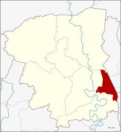
Amphoe Phutthamonthon
|
Phutthamonthon พุทธ มณฑล |
|
|---|---|
| Province: | Nakhon Pathom |
| Surface: | 52.3 km² |
| Residents: | 37,435 (2013) |
| Population density : | 422 U / km² |
| ZIP : | 73170 |
| Geocode : | 7307 |
| map | |

|
|
Amphoe Phutthamonthon ( Thai : อำเภอ พุทธ มณฑล , pronunciation: ʔāmpʰɤ̄ː pʰút.tʰā.mōn.tʰōn , other spelling: "Buddha Monthon") is a district ( Amphoe - administrative district) in the province of Nakhon Pathom . The Nakhon Pathom Province is located in the middle of the central region of Thailand .
geography
The neighboring Amphoe are clockwise from the north: Bang Len Amphoe in Nakhon Pathom Province, Sai Noi , Bang Yai and Bang Kruai Amphoe in Nonthaburi Province , the Thawi Watthana District ( Khet ) of Bangkok and the Sam Phran and Nakhon Amphoe Chai Si in turn in Nakhon Pathom.

history
Amphoe Phuttamonthon was initially set up as a “branch circle” ( King Amphoe ) on April 1, 1991 by splitting off three tambon from Amphoe Nakhon Chai Si. On December 5, 1996, he received full amphoe status.
education
A Mahidol University campus is located in this district.
Attractions
- Phutthamonthon Park - a " Buddhist park" with an approximately 16 meter high Buddha statue created by Silpa Bhirasri , which is considered the highest free-standing Buddha statue in the world.
administration
Provincial Administration
The district of Phutthamonthon is divided into three tambon ("subdistricts" or "communities"), which are further subdivided into 18 muban ("villages").
| No. | Surname | Thai | Muban | Pop. |
|---|---|---|---|---|
| 1. | Salaya | ศาลา ยา | 6th | 19,916 |
| 2. | Khlong Yong | คลอง โยง | 8th | 8,854 |
| 3. | Maha Sawat | มหา สวัสดิ์ | 4th | 8,665 |
Local administration
There are two municipalities with "small town" status ( Thesaban Tambon ) in the district:
- Salaya (Thai: เทศบาล ตำบล ศาลา ยา ) consisting of parts of the Tambon Salaya.
- Khlong Yong (Thai: เทศบาล ตำบล คลอง โยง ) consisting of the complete tambon Khlong Yong.
There are also two " tambon administration organizations " ( องค์การ บริหาร ส่วน ตำบล - Tambon Administrative Organizations, TAO)
- Salaya (Thai: องค์การ บริหาร ส่วน ตำบล ศาลา ยา ) consisting of parts of the Tambon Salaya.
- Maha Sawat (Thai: องค์การ บริหาร ส่วน ตำบล มหา สวัสดิ์ ) consisting of the complete Tambon Maha Sawat.
Individual evidence
- ↑ ประกาศ กระทรวง มหาดไทย เรื่อง แบ่ง เขต ท้องที่ อำเภอ นครชัยศรี จังหวัด นครปฐม ตั้ง เป็น กิ่ง อำเภอ พุทธ มณฑล Royal Gazette, Vol. 108, Issue 15 ง of January 31, 1991, p. 1067 (in Thai)
- ↑ พระราชกฤษฎีกา ตั้ง อำเภอ เหนือ คลอง อำเภอ นา ยาย อาม อำเภอ ท่า ตะเกียบ อำเภอ ขุน ตาล อำเภอ แม่ ฟ้า หลวง อำเภอ แม่ ลาว อำเภอ รั ษ ฎา อำเภอ อำเภอ พุทธ มณฑล อำเภอ วัง วัง น้ำ เขียว อำเภอ เจาะ ไอ ร้อง อำเภอ ชำนิ อำเภอ โนน ดินแดง อำเภอ ปาง สนธิ อำเภอ อำเภอ อำเภอ อำเภอ อำเภอ อำเภอ อำเภอ หนอง ม่วง อำเภอ เบญจ ลัก ษ์ อำเภอ โพน นา แก้ว อำเภอ บุ่ง คล้า อำเภอ ดอน มดแดง และ อำเภอ ลือ อำนาจ พ.ศ. ๒๕๓๙ Royal Gazette, Vol. 113, Ed. 62 ก November 20, 1996, pp. 5–8 (in Thai)
- ↑ 2013 population statistics ( Thai ) Department of Provincial Administration. Retrieved August 9, 2014.
Web links
- More information about the Amphoe Phutthamonthon from amphoe.com (in Thai). Archived from the original on September 18, 2010 ; Retrieved July 29, 2015 .
Coordinates: 13 ° 48 ' N , 100 ° 19' E
