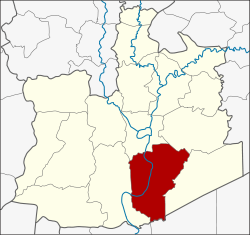
Bang Pa-in district
|
Bang Pa-in บางปะอิน |
|
|---|---|
| Province: | Ayutthaya |
| Surface: | 229.1 km² |
| Residents: | 99,871 (2013) |
| Population density : | 321 U / km² |
| ZIP : | 13160, 13170, 13180 |
| Geocode : | 1406 |
| map | |

|
|
Amphoe Bang Pa-in ( Thai อำเภอ บางปะอิน , pronunciation: ʔāmpʰɤ̄ː.bāːŋ.pā.ʔīn ) is a district ( Amphoe - administrative district) of Ayutthaya Province ("Phra Nakhon Si Ayutthaya Province"). Ayutthaya Province is located in the central region of Thailand .
geography
Bang Pa-in is located about 50 kilometers north of Bangkok on the Mae Nam Chao Phraya (Chao Phraya River) . This is also where the royal summer palace of the same name is located.
Neighboring counties are (clockwise from north): the Amphoe Phra Nakhon Si Ayutthaya , Uthai and Wang Noi in the province of Ayutthaya, Amphoe Khlong Luang in the province of Pathum Thani and Amphoe Bang Sai again in Ayutthaya.
history
Bang Pa-In was already established in the Kingdom of Ayutthaya . It was initially called Khwaeng U Thai. In the Rattanakosin era, Khwaeng U Thai was divided into Khwaeng U Thai Noi and U Thai Yai. In 1910, Khwaeng U Thai Noi was renamed Phra Ratchawang and received amphoe status . Later in 1915 the district was renamed Bang Pa-In after the island of Bang Pa-In in Chao Phraya.
administration
Provincial Administration
Bang Pa-in County is divided into 18 tambon ("subdistricts" or "parishes"), which are further subdivided into 149 muban ("villages").
| No. | Surname | Thai | Muban | Pop. |
|---|---|---|---|---|
| 1. | Ban Len | บ้าน เลน | 12 | 12,179 |
| 2. | Chiang Rak Noi | เชียง ราก น้อย | 12 | 18.091 |
| 3. | Ban Pho | บ้าน โพ | 9 | 3,063 |
| 4th | Ban Krot | บ้าน กรด | 11 | 7,889 |
| 5. | Bang Krasan | บาง กระ สั้น | 17th | 11,556 |
| 6th | Khlong Chik | คลอง จิก | 8th | 8,100 |
| 7th | Ban Wa | บ้าน หว้า | 7th | 2,815 |
| 8th. | Wat Yom | วัด ยม | 8th | 3,001 |
| 9. | Bang Pradaeng | บาง ประแดง | 9 | 2,193 |
| 10. | Sam Ruean | สาม เรือน | 8th | 7,896 |
| 11. | Ko Koet | เกาะ เกิด | 7th | 2.167 |
| 12. | Ban Phlap | บ้าน พลับ | 5 | 2,357 |
| 13. | Ban Paeng | บ้าน แป้ง | 4th | 2,087 |
| 14th | Khung Lan | คุ้ง ลาน | 5 | 3,097 |
| 15th | Taling Chan | ตลิ่งชัน | 6th | 1,412 |
| 16. | Ban Sang | บ้าน สร้าง | 8th | 7,360 |
| 17th | Talat Kriap | ตลาด เกรียบ | 8th | 2,930 |
| 18th | Khanon Luang | ขนอน หลวง | 5 | 1,678 |
Local administration
There are nine municipalities with "small town" status ( Thesaban Tambon ) in the district:
- Ban Krot (Thai: เทศบาล ตำบล บ้าน กรด ) consisting of the complete tambon Ban Krot.
- Talat Kriap (Thai: เทศบาล ตำบล ตลาด เกรียบ ) consisting of the complete Tambon Talat Kriap.
- Bang Pa-in (Thai: เทศบาล ตำบล บางปะอิน ) consisting of parts of the Tambon Ban Len.
- Ban Sang (Thai: เทศบาล ตำบล บ้าน สร้าง ) consisting of the complete tambon Ban Sang.
- Phra Inthracha (Thai: เทศบาล ตำบล พระ อินทรา ชา ) consisting of parts of the Tambon Chiang Rak Noi.
- Prasat Thong (Thai: เทศบาล ตำบล ปราสาท ทอง ) consisting of parts of the Tambon Ban Len.
- Khlong Chik (Thai: เทศบาล ตำบล คลอง จิก ) consisting of the complete Tambon Khlong Chik.
- Chiang Rak Noi (Thai: เทศบาล ตำบล เชียง ราก น้อย ) consisting of parts of the Tambon Chiang Rak Noi.
- Bang Krasan (Thai: เทศบาล ตำบล บาง กระ สั้น ) consisting of the complete Tambon Bang Krasan.
In addition, there are nine " tambon administration organizations " ( องค์การ บริหาร ส่วน ตำบล - Tambon Administrative Organizations, TAO)
- Ban Pho (Thai: องค์การ บริหาร ส่วน ตำบล บ้าน โพ ) consisting of the complete tambon Ban Pho, Khanon Luang.
- Ban Wa (Thai: องค์การ บริหาร ส่วน ตำบล บ้าน หว้า ) consisting of the complete tambon Ban Wa.
- Wat Yom (Thai: องค์การ บริหาร ส่วน ตำบล วัด ยม ) consisting of the complete tambon Wat Yom.
- Bang Pradaeng (Thai: องค์การ บริหาร ส่วน ตำบล บาง ประแดง ) consisting of the complete Tambon Bang Pradaeng.
- Sam Ruean (Thai: องค์การ บริหาร ส่วน ตำบล สาม เรือน ) consisting of the complete Tambon Sam Ruean.
- Ko Koet (Thai: องค์การ บริหารส่วน ตำบล เกาะ เกิด ) consisting of the complete tambon Ko Koet.
- Ban Phlap (Thai: องค์การ บริหาร ส่วน ตำบล บ้าน พลับ ) consisting of the complete tambon Ban Phlap.
- Ban Paeng (Thai: องค์การ บริหาร ส่วน ตำบล บ้าน แป้ง ) consisting of the complete tambon Ban Paeng.
- Taling Chan (Thai: องค์การ บริหาร ส่วน ตำบล ตลิ่งชัน ) consisting of the complete Tambon Khung Lan, Taling Chan.
Individual evidence
- ↑ 2013 population statistics ( Thai ) Department of Provincial Administration. Retrieved August 12, 2014.
Web links
Coordinates: 14 ° 14 ' N , 100 ° 35' E
