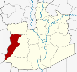
Bang Sai District (1413)
|
Bang Sai บางซ้าย |
|
|---|---|
| Province: | Ayutthaya |
| Surface: | 150.7 km² |
| Residents: | 19,501 (2013) |
| Population density : | 129.9 U / km² |
| ZIP : | 13270 |
| Geocode : | 1413 |
| map | |

|
|
Amphoe Bang Sai ( Thai : อำเภอ บางซ้าย , pronunciation: ʔāmpʰɤ̄ː bāːŋ sáːj ) is a district ( Amphoe - administrative district) in the western part of Ayutthaya Province ("Phra Nakhon Si Ayutthaya Province"). Ayutthaya Province is located in the central region of Thailand .
There is another district of Bang Sai in the province of Ayutthaya, whose name is Romanized in the same spelling, but the Thai spelling is different ( บางไทร ).
geography
Neighboring districts are (from north clockwise) Phak Hai , Sena and Lat Bua Luang Ayutthaya province and Amphoe Bang Pla Ma the province of Suphan Buri .
history
Amphoe Bang Sai was first established in 1948 as a “branch circle” ( King Amphoe ) by separating it from Amphoe Sena . In 1959 he got full amphoe status.
administration
Provincial Administration
Bang Sai County is divided into six tambon ("subdistricts" or "parishes"), which are further subdivided into 53 muban ("villages").
| No. | Surname | Thai | Muban | Pop. |
|---|---|---|---|---|
| 1. | Bang Sai | บางซ้าย | 8th | 3,436 |
| 2. | Kaeo company | แก้ว ฟ้า | 7th | 2,474 |
| 3. | Tao Lao | เต่า เล่า | 10 | 2,857 |
| 4th | Plai Klat | ปลาย กลัด | 12 | 4,624 |
| 5. | Thepphamongkhon | เทพ มงคล | 8th | 3.811 |
| 6th | Wang Phatthana | วัง พัฒนา | 8th | 2,299 |
Local administration
There is one municipality with "small town" status ( Thesaban Tambon ) in the district:
- Bang Sai (Thai: เทศบาล ตำบล บางซ้าย ) consisting of the parts of the Tambon Bang Sai, Kaeo Fa, Tao Lao.
There are also four " tambon administration organizations " ( องค์การ บริหาร ส่วน ตำบล - Tambon Administrative Organizations, TAO)
- Bang Sai (Thai: องค์การ บริหาร ส่วน ตำบล บางซ้าย ) consisting of the parts of the Tambon Bang Sai, Kaeo Fa.
- Plai Klat (Thai: องค์การ บริหาร ส่วน ตำบล ปลาย กลัด ) consisting of the complete tambon Plai Klat and parts of the Tambon Tao Lao.
- Thepphamongkhon (Thai: องค์การ บริหารส่วน ตำบล เทพ มงคล ) consisting of the complete tambon Thepphamongkhon.
- Wang Phatthana (Thai: องค์การ บริหาร ส่วน ตำบล วัง พัฒนา ) consisting of the complete tambon Wang Phatthana.
Individual evidence
- ↑ ประกาศ กระทรวง มหาดไทย เรื่อง ยก ฐานะ ตำบล ขึ้น เป็น กิ่ง อำเภอ Royal Gazette Volume64, Ed. 60 ง of December 9, 1947, pp. 3188–3193 (in Thai)
- ↑ พระราชกฤษฎีกา จัดตั้ง อำเภอ กระสัง อำเภอ กระนวน อำเภอ บางกอกใหญ่ อำเภอ ขุน หาร อำเภอ พนา อำเภอ ปากช่อง อำเภอ วังเหนือ อำเภอ วัง ชิ้น อำเภอ แม่ทา อำเภอ หนอง หมู อำเภอ สระแก้ว สระแก้ว อำเภอ อมก๋อย อำเภอ บางซ้าย บางซ้าย อำเภอ ทับสะแก อำเภอ บุณฑริก อำเภอ ลานสะกา อำเภอ จอมบึง อำเภอ ท่ายาง อำเภอ สามเงา อำเภอ อำเภอ ชานุมาน บ้านเขว้า บ้านเขว้า บ้านเขว้า บ้านเขว้า บ้านเขว้า บ้านเขว้า อำเภอ แม่พริก อำเภอ ท่าสองยาง อำเภอ สะเมิง อำเภอ หนองแขม อำเภอ พระแสง พ.ศ. ๒๕๐๑ Royal Gazette Volume 75, Ed. 55 ก July 22, 1958, pp. 321–327 (in Thai)
- ↑ 2013 population statistics ( Thai ) Department of Provincial Administration. Retrieved August 12, 2014.
Web links
Coordinates: 14 ° 19 ′ N , 100 ° 18 ′ E
