Amphoe Pa Mok
|
Pa Mok ป่าโมก |
|
|---|---|
| Province: | Ang Thong |
| Surface: | 80.9 km² |
| Residents: | 28,759 (2013) |
| Population density : | 348 U / km² |
| ZIP : | 14130 |
| Geocode : | 1503 |
| map | |

|
|
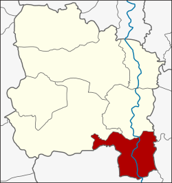
Amphoe Pa Mok ( Thai อำเภอ ป่าโมก ) is the southernmost district ( Amphoe - administrative district) of Ang Thong Province . Ang Thong Province is located in the middle of the central region of Thailand .
geography
Neighboring districts are (from north clockwise): Amphoe Wiset Chai Chan and Mueang Ang Thong province Ang Thong and Amphoe Maha Rat , Bang Pahan , Bang Ban and Phak Hai of Ayutthaya province .
history
This area was once called Ban Pa Mok Noi. In 1585 King Naresuan pitched his army camp here. Before he led his troops into the battle against the Phra Maha Uparacha, the Burmese Crown Prince, at Don Chedi, he paid homage to the Reclining Buddha of Wat Pa Mok. According to legend, he won the battle. (See the "controversy" in: Don Chedi .)
The district of Pa Mok was separated from the Amphoe Mueang Ang Thong in 1902 and thus received full amphoe status. The first administrative building in the new district was completed in 1904.
Attractions
- Wat Pa Mok Worawihan ( วัด ป่าโมก วรวิหาร ) - Buddhist temple complex ( Wat ) on the western bank of the Mae Nam Chao Phraya ( Chao Phraya River ) from the Ayutthaya period with an approximately 22.5 m long reclining Buddha statue . The temple got its name from the many mok trees ( Apocynaceae ) that stood here in the past.
- Wat Tha Sutthawat ( วัด ท่า สุทธาวาส ) - Buddhist temple complex on the banks of the Chao Phraya from the early Ayutthaya period. Sponsored by Princess Maha Chakri Sirindhorn , a pavilion and a chedi have been built here in recent years . The modern wall paintings in the Ubosot were also commissioned by her.
- Wat Sa Kaeo ( วัดสระแก้ว , also Wat Sakaew ) - large Buddhist temple with an orphanage run by a private organization, in which over 1000 orphans live.
- Ban Ekkarat - near Pa Mok on Mae Nam Chao Phraya with a unique production of drums of all types and sizes
administration
Provincial Administration
Pa Mok County is divided into eight tambon ("subdistricts" or "municipalities"), which are further subdivided into 47 Muban ("villages").
| No. | Surname | Thai | Muban | Pop. |
|---|---|---|---|---|
| 1. | Bang Pla feces | บาง ปลา กด | - | 2,773 |
| 2. | Pa Mok | ป่าโมก | - | 6,629 |
| 3. | Sai Thong | สาย ทอง | 8th | 3,178 |
| 4th | Rong Chang | โรง ช้าง | 8th | 3,556 |
| 5. | Bang Sadet | บาง เสด็จ | 6th | 3.135 |
| 6th | Norasing | นรสิงห์ | 7th | 2,779 |
| 7th | Eccarat | เอกราช | 8th | 3,383 |
| 8th. | Phong Pheng | โผงเผง | 10 | 3,326 |
Local administration
There is one municipality with "small town" status ( Thesaban Tambon ) in the district:
- Pa Mok (Thai: เทศบาล ตำบล ป่าโมก ) consisting of the complete Tambon Bang Pla Kot, Pa Mok.
In addition, there are six " tambon administration organizations " ( องค์การ บริหาร ส่วน ตำบล - Tambon Administrative Organizations, TAO)
- Sai Thong (Thai: องค์การ บริหาร ส่วน ตำบล สาย ทอง ) consisting of the complete tambon Sai Thong.
- Rong Chang (Thai: องค์การ บริหาร ส่วน ตำบล โรง ช้าง ) consisting of the complete Tambon Rong Chang.
- Bang Sadet (Thai: องค์การ บริหาร ส่วน ตำบล บาง เสด็จ ) consisting of the complete Tambon Bang Sadet.
- Norasing (Thai: องค์การ บริหาร ส่วน ตำบล นรสิงห์ ) consisting of the complete tambon Norasing.
- Ekkarat (Thai: องค์การ บริหาร ส่วน ตำบล เอกราช ) consisting of the complete Tambon Ekkarat.
- Phong Pheng (Thai: องค์การ บริหาร ส่วน ตำบล โผงเผง ) consisting of the complete Tambon Phong Pheng.
Individual evidence
- ↑ 2013 population statistics ( Thai ) Department of Provincial Administration. Retrieved August 10, 2014.
Web links
- More information about the Amphoe Pa Mok at amphoe.com (in Thai)
- Wat Sa Kaeo website (in Thai; last accessed on August 10, 2014)
Coordinates: 14 ° 29 ' N , 100 ° 27' E

