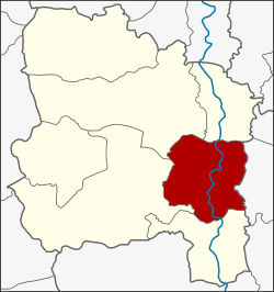
Amphoe Mueang Ang Thong
|
Mueang Ang Thong เมือง อ่างทอง |
|
|---|---|
| Province: | Ang Thong |
| Surface: | 102.8 km² |
| Residents: | 56,523 (2013) |
| Population density : | 480.3 U / km² |
| ZIP : | 14000 |
| Geocode : | 1501 |
| map | |

|
|
Amphoe Mueang Ang Thong ( Thai : อำเภอ เมือง อ่างทอง ) is a district ( amphoe - administrative district) in Ang Thong Province . Ang Thong Province is located in the center of the central region of Thailand .
geography
Ang Thong is just over 100 kilometers north of the state capital Bangkok .
Neighboring counties are (clockwise from the south) the Amphoe Pa Mok , Wiset Chai Chan , Pho Thong and Chaiyo in the province of Ang Thong and Amphoe Maha Rat in the province of Ayutthaya .
The main river in the district is the Mae Nam Chao Phraya ( Chao Phraya River ) and the Khlong Bang Kaeo ( Bang Kaeo Canal ).
history
The area of today's district was also called "Amphoe Mueang" in the past. Its administration was established on the west bank of the Chao Phraya opposite Wat Chai Songkhram in Tambon Ban Hae.
In 1813, King Nang Klao ( Rama II ) commissioned the Chao Phraya Aphai Phuthon ( เจ้าพระยา อภัย ภูธร ) to build a dam through the Chao Phraya in order to keep the water level of the Khlong Bang Kaeo high enough for water transport all year round. Since the project was unsuccessful, the provincial administration was moved across from the mouth of the Khlong Bang Kaeo on the east bank of the Chao Phraya. At the same time, the district administration was also relocated. In 1917 the county was renamed Bang Kaeo after the name of the central tambon . The district administration was rebuilt in 1926 about 300 meters south of the provincial administration. In 1938 the district was renamed again in Amphoe Mueang Ang Thong.
administration
Provincial Administration
Mueang Ang Thong County is divided into 14 tambon ("subdistricts" or "parishes"), which are further subdivided into 81 muban ("villages").
| No. | Surname | Thai | Muban | Pop. |
|---|---|---|---|---|
| 1. | Talat Luang | ตลาด หลวง | - | 6,724 |
| 2. | Bang Kaeo | บางแก้ว | - | 2,225 |
| 3. | Sala Daeng | ศาลาแดง | 7th | 7,474 |
| 4th | Pa Ngio | ป่า งิ้ว | 7th | 5,187 |
| 5. | Ban Hae | บ้าน แห | 6th | 4,286 |
| 6th | Talat Kruat | ตลาด กรวด | 6th | 2,071 |
| 7th | Mahat Thai | มหาดไทย | 6th | 1,624 |
| 8th. | Ban It | บ้าน อิฐ | 11 | 6,691 |
| 9. | Hua Phai | หัว ไผ่ | 9 | 4,362 |
| 10. | Champa Lo | จำปา หล่อ | 7th | 3,653 |
| 11. | Phosa | โพ สะ | 8th | 4,317 |
| 12. | Ban Ri | บ้าน รี | 4th | 1.929 |
| 13. | Khlong Wua | คลอง วัว | 5 | 2,225 |
| 14th | Yan Sue | ย่านซื่อ | 5 | 3,755 |
Local administration
There is one commune with "city" status ( Thesaban Mueang ) in the district:
- Ang Thong (Thai: เทศบาล เมือง อ่างทอง ) consisting of the complete Tambon Talat Luang, Bang Kaeo and the parts of the Tambon Sala Daeng, Ban Hae, Ban It, Phosa, Yan Sue.
There are two municipalities with "small town" status ( Thesaban Tambon ) in the district:
- Sala Daeng (Thai: เทศบาล ตำบล ศาลาแดง ) consisting of parts of the Tambon Sala Daeng.
- Phosa (Thai: เทศบาล ตำบล โพ สะ ) consisting of parts of the Tambon Phosa.
In addition, there are eight " tambon administration organizations " ( องค์การ บริหาร ส่วน ตำบล - Tambon Administrative Organizations, TAO)
- Pa Ngio (Thai: องค์การ บริหาร ส่วน ตำบล ป่า งิ้ว ) consisting of the complete Tambon Pa Ngio, Mahat Thai.
- Ban Hae (Thai: องค์การ บริหาร ส่วน ตำบล บ้าน แห ) consisting of parts of the Tambon Ban Hae.
- Talat Kruat (Thai: องค์การ บริหาร ส่วน ตำบล ตลาด กรวด ) consisting of the complete Tambon Talat Kruat.
- Ban It (Thai: องค์การ บริหาร ส่วน ตำบล บ้าน อิฐ ) consisting of the complete Tambon Ban Ri and parts of the Tambon Ban It.
- Hua Phai (Thai: องค์การ บริหาร ส่วน ตำบล หัว ไผ่ ) consisting of the complete Tambon Hua Phai.
- Champa Lo (Thai: องค์การ บริหาร ส่วน ตำบล จำปา หล่อ ) consisting of the complete tambon Champa Lo.
- Khlong Wua (Thai: องค์การ บริหาร ส่วน ตำบล คลอง วัว ) consisting of the complete tambon Khlong Wua.
- Yan Sue (Thai: องค์การ บริหาร ส่วน ตำบล ย่านซื่อ ) consisting of parts of the tambon Yan Sue.
Individual evidence
- ↑ ประกาศ กระทรวง มหาดไทย เรื่อง เปลี่ยน ชื่อ อำเภอ . In: Royal Gazette . 34, No. 0 ก , April 29, 1917, pp. 40-68.
- ↑ พระราชกฤษฎีกา เปลี่ยน นาม จังหวัด และ อำเภอ บาง แห่ง พุทธศักราช ๒๔๘๑ . In: Royal Gazette . 55, No. 0 ก , November 14, 1938, pp. 658-666.
- ↑ 2013 population statistics ( Thai ) Department of Provincial Administration. Retrieved August 10, 2014.
Web links
Coordinates: 14 ° 35 ' N , 100 ° 27' E
