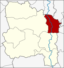
Chaiyo district
|
Chaiyo ไชโย |
|
|---|---|
| Province: | Ang Thong |
| Surface: | 72.3 km² |
| Residents: | 22,984 (2013) |
| Population density : | 316.5 U / km² |
| ZIP : | 14140 |
| Geocode : | 1502 |
| map | |

|
|
Amphoe Chaiyo ( Thai อำเภอ ไชโย ) is a district ( Amphoe - Administrative District) in the eastern part of Ang Thong Province . Ang Thong Province is located in the center of the central region of Thailand .
geography
Neighboring districts (from north clockwise): Amphoe Phrom Buri of Sing Buri Province , Amphoe Tha Wung and Mueang Lop Buri of Lop Buri Province , Amphoe Ban Phraek and Maha Rat of Ayutthaya Province , and finally Amphoe Mueang Ang Thong and Pho Thong Ang Thong Province.
history
The name of Ban Chaiyo goes back to King Naresuan and his brother, who later became King Ekathotsarot . Here they won a battle against the King of Lan Na and Burmese soldiers. Ayutthaya fighters shouted "Chaiyo" to celebrate the victory.
In the past, Chaiyo district was called Ban Makham district. When Chaiyo was officially granted Amphoe status, the government chose the name Chaiyo because it was a "big name".
Attractions
- Wat Chaiyo Worawihan - a second class royal temple from the time of King Mongkut (Rama IV) . The big Buddha statue called Phra Maha Phuttha Phim is worth seeing . The temple is also known for the fact that very effective amulets ( Phra Phim ) are made here.
administration
Provincial Administration
Chaiyo County is divided into nine tambon ("subdistricts" or "parishes"), which are further subdivided into 51 muban ("villages").
| No. | Surname | Thai | Muban | Pop. |
|---|---|---|---|---|
| 1. | Chorakhe Rong | จร เข้ ร้อง | 7th | 3,040 |
| 2. | Chaiyaphum | ไชย ภูมิ | 8th | 3,427 |
| 3. | Chaiyarit | ชัย ฤทธิ์ | 6th | 3.214 |
| 4th | Thewarat | เทว ราช | 7th | 2.010 |
| 5. | Ratchasathit | ราช สถิตย์ | 7th | 2,305 |
| 6th | Chaiyo | ไชโย | 7th | 2,848 |
| 7th | Lak Fa | หลัก ฟ้า | 3 | 1,560 |
| 8th. | Chawai | ชะ ไว | 3 | 3,059 |
| 9. | Tri Narong | ตรี ณรงค์ | 3 | 1,521 |
Local administration
There are two municipalities with "small town" status ( Thesaban Tambon ) in the district:
- Ket Chaiyo (Thai: เทศบาล ตำบล เก ษ ไชโย ) consisting of parts of the Tambon Chaiyo.
- Chaiyo (Thai: เทศบาล ตำบล ไชโย ) consisting of the complete Tambon Chorakhe Rong, Chaiyaphum, Lak Fa, Chawai, Tri Narong and the parts of the Tambon Chaiyarit, Chaiyo.
There are also three " tambon administration organizations " ( องค์การ บริหาร ส่วน ตำบล - Tambon Administrative Organizations, TAO)
- Chaiyarit (Thai: องค์การ บริหารส่วน ตำบล ชัย ฤทธิ์ ) consisting of parts of the tambon chaiyarit.
- Thewarat (Thai: องค์การ บริหาร ส่วน ตำบล เทว ราช ) consisting of the complete tambon Thewarat.
- Ratchasathit (Thai: องค์การ บริหาร ส่วน ตำบล ราช สถิตย์ ) consisting of the complete tambon ratchasathit.
Individual evidence
- ↑ 2013 population statistics ( Thai ) Department of Provincial Administration. Retrieved August 10, 2014.
Web links
Coordinates: 14 ° 39 ' N , 100 ° 29' E
