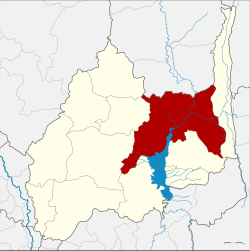
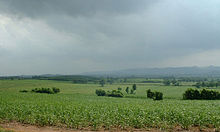
Chai Badan district
|
Chai Badan ชัยบาดาล |
|
|---|---|
| Province: | Lop Buri |
| Surface: | 1253.0 km² |
| Residents: | 91,049 (2013) |
| Population density : | 70.7 U / km² |
| ZIP : | 15130, 15230, 15190 |
| Geocode : | 1604 |
| map | |

|
|
Amphoe Chai Badan ( Thai : อำเภอ ชัยบาดาล ) is a district ( Amphoe - administrative district) in the east of Lop Buri Province in central Thailand .
The district is also called Lam Narai by the locals because its center is in the Tambon Lam Narai.
geography
Neighboring Amphoe is seen from the east: the Amphoe Lam Sonthi , Tha Luang , Phatthana Nikhom , Khok Samrong and Khok Charoen of the Province of Lop Buri and Amphoe Si Thep of the Province of Phetchabun .
history
Chai Badan was an ancient city in the Maenam Pa Sak (Pa-Sak River) valley , ruled from Nakhon Ratchasima . In 1914 it was promoted to an Amphoe of Phetchabun Province . In 1918 the county became part of Saraburi Province . On November 1, 1941, it was finally awarded to Lop Buri Province .
In 1943 the district administration was moved from Tambon Chai Badan to Tambon Bua Chum, but this was reversed in the following year. In 1960 the administration was moved back to Bua Chum. The area around the county council was declared the new Tambon Lam Narai in 1970 .
Attractions
The Wang Kan Luang Waterfall is a popular destination for visitors from Lop Buri and the surrounding provinces.
administration
Provincial Administration
The district of Chai Badan is divided into 17 tambon ("subdistricts" or "municipalities"), which are further subdivided into 136 muban ("villages").
| No. | Surname | Thai | Muban | Pop. |
|---|---|---|---|---|
| 1. | Lam Narai | ลำ นารายณ์ | 12 | 17,270 |
| 2. | Chai Narai | ชัย นารายณ์ | 6th | 6,294 |
| 3. | Sila Thip | ศิลา ทิพย์ | 12 | 5,660 |
| 4th | Huai Hin | ห้วย หิน | 8th | 2,717 |
| 5. | Muang Khom | ม่วง ค่อม | 11 | 5,902 |
| 6th | Bua Chum | บัว ชุม | 9 | 8,111 |
| 7th | Tha Din Dam | ท่า ดินดำ | 6th | 4,505 |
| 8th. | Makok Wan | มะกอก หวาน | 3 | 1,489 |
| 9. | Sap Takhian | ซับ ตะเคียน | 6th | 4,910 |
| 10. | Well som | นา โสม | 6th | 2,676 |
| 11. | Nong Yai To | หนอง ยาย โต๊ะ | 8th | 4,107 |
| 12. | Ko rank | เกาะ รัง | 10 | 6,662 |
| 14th | Tha Manao | ท่า มะนาว | 8th | 3,294 |
| 17th | Nikhom Lam Narai | นิคม ลำ นารายณ์ | 9 | 4,506 |
| 18th | Chai Badan | ชัยบาดาล | 8th | 6,513 |
| 19th | Ban Mai Samakkhi | บ้าน ใหม่ สามัคคี | 6th | 2,996 |
| 22nd | Khao Laem | เขา แหลม | 8th | 3,437 |
Note: The missing geocodes belong to the tambon that now consists of Amphoe Lam Sonthi .
Local administration
There is one municipality with "small town" status ( Thesaban Tambon ) in the district:
- Lam Narai (Thai: เทศบาล ตำบล ลำ นารายณ์ ) consisting of the parts of the Tambon Lam Narai, Chai Narai.
There are also 16 " tambon administration organizations " ( องค์การ บริหาร ส่วน ตำบล - Tambon Administrative Organizations, TAO)
- Lam Narai (Thai: องค์การ บริหาร ส่วน ตำบล ลำ นารายณ์ ) consisting of parts of the Tambon Lam Narai.
- Chai Narai (Thai: องค์การ บริหาร ส่วน ตำบล ชัย นารายณ์ ) consisting of parts of the Tambon Chai Narai.
- Sila Thip (Thai: องค์การ บริหาร ส่วน ตำบล ศิลา ทิพย์ ) consisting of the complete Tambon Sila Thip.
- Huai Hin (Thai: องค์การ บริหาร ส่วน ตำบล ห้วย หิน ) consisting of the complete tambon Huai Hin.
- Muang Khom (Thai: องค์การ บริหาร ส่วน ตำบล ม่วง ค่อม ) consisting of the complete tambon Muang Khom.
- Bua Chum (Thai: องค์การ บริหาร ส่วน ตำบล บัว ชุม ) consisting of the complete tambon Bua Chum.
- Tha Din Dam (Thai: องค์การ บริหาร ส่วน ตำบล ท่า ดินดำ ) consisting of the complete tambon Tha Din Dam.
- Sap Takhian (Thai: องค์การ บริหาร ส่วน ตำบล ซับ ตะเคียน ) consisting of the complete Tambon Sap Takhian.
- Na Som (Thai: องค์การ บริหาร ส่วน ตำบล นา โสม ) consisting of the complete tambon Na Som.
- Nong Yai To (Thai: องค์การ บริหาร ส่วน ตำบล หนอง ยาย โต๊ะ ) consisting of the complete tambon Nong Yai To.
- Ko Rang (Thai: องค์การ บริหาร ส่วน ตำบล เกาะ รัง ) consisting of the complete Tambon Ko Rang.
- Tha Manao (Thai: องค์การ บริหาร ส่วน ตำบล ท่า มะนาว ) consisting of the complete Tambon Tha Manao.
- Nikhom Lam Narai (Thai: องค์การ บริหาร ส่วน ตำบล นิคม ลำ นารายณ์ ) consisting of the complete tambon Nikhom Lam Narai.
- Chai Badan (Thai: องค์การ บริหาร ส่วน ตำบล ชัยบาดาล ) consisting of the complete Tambon Chai Badan, Makok Wan.
- Ban Mai Samakkhi (Thai: องค์การ บริหาร ส่วน ตำบล บ้าน ใหม่ สามัคคี ) consisting of the complete tambon Ban Mai Samakkhi.
- Khao Laem (Thai: องค์การ บริหาร ส่วน ตำบล เขา แหลม ) consisting of the complete tambon Khao Laem.
Individual evidence
- ↑ พระราชบัญญัติ เปลี่ยนแปลง เขต จังหวัด ลพบุรี และ จังหวัด สระบุรี พุทธศักราช ๒๔๘๔ Royal Gazette, Volume 58, Issue 0 ก of October 14, 1941, pp. 1379-1381 (in Thai)
- ↑ ประกาศ กระทรวง มหาดไทย เรื่อง ย้าย ที่ว่าการ อำเภอ ชัยบาดาล จังหวัด ลพบุรี . In: Royal Gazette . 60, No. 56 ง , October 19, 1943, p. 3385.
- ↑ ประกาศ กระทรวง มหาดไทย เรื่อง ย้าย ที่ว่าการ อำเภอ ชัยบาดาล จังหวัด ลพบุรี . In: Royal Gazette . 61, No. 77 ง , December 26, 1944, pp. 2445-2446.
- ↑ ประกาศ กระทรวง มหาดไทย เรื่อง ย้าย ที่ว่าการ อำเภอ ไชย บาดาล และ สถานี ตำรวจภูธร . In: Royal Gazette . 77, No. 47 ง , June 7, 1960, p. 1509.
- ↑ ประกาศ กระทรวง มหาดไทย เรื่อง ตั้ง และ เปลี่ยนแปลง เขต ตำบล ใน ท้องที่ อำเภอ ชัยบาดาล จังหวัด ลพบุรี . In: Royal Gazette . 87, No. 85 ง , September 8, 1970, pp. 2539-2545.
- ↑ 2013 population statistics ( Thai ) Department of Provincial Administration. Retrieved August 31, 2014.
Web links
Coordinates: 15 ° 12 ' N , 101 ° 8' E

