Salavan Province
| ສາ ລະ ວັນ Salavan
|
|
|---|---|
| Basic data | |
| Country | Laos |
| Capital | Salavan |
| surface | 10,691 km² |
| Residents | 396,942 (2015 census) |
| density | 37 inhabitants per km² |
| ISO 3166-2 | LA-SL |
| The village of Ban Huay Lanong in Salavan Province | |
Coordinates: 15 ° 54 ' N , 106 ° 18' E
Salavan (also: Saravane or Saravan , Lao ສາ ລະ ວັນ ) is a province in the south of Laos .
geography
The province of Salavan borders on the province of Savannakhet in the north, on the province of Champasak in the southwest and on the province of Sekong in the southeast . The western border of the province is formed by the Mekong , on the opposite bank is the Ubon Ratchathani province in Thailand . In the east, Salavan borders on the province of Quảng Trị in Vietnam .
The province is partly located on the Bolaven Plateau .
Administrative structure
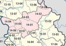
The province consists of the following districts ( ເມືອງ - Muang):
Web links
Commons : Province of Salavan - Collection of pictures, videos and audio files
- LaoTourism.org page about Salavan (in English)


