Bolaven Plateau

The Bolaven Plateau is a 1,200 meter high and 10,000 km² large plateau in Laos .
Most of the plateau is located in Champasak Province . Various ethnic groups that belong to the Mon Khmer language family live on the plateau . With around 50,000 people, the largest group is that of the lavas . The plateau was named after them (Bolaven = home of the lavas ). In the region, agriculture is mainly practiced: rubber , cardamom , pepper , green tea and coffee are grown , which gives the plateau national importance.
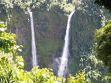
The Tad Fane (the highest waterfall in Laos at 120 meters ) and the Tad Phasuam , Tad Lo , Tad E-Tu , Tad Champee and Tad Nyuang waterfalls are located in the Bolaven Plateau.
During the Second Indochina War , the region was heavily bombed during air strikes by the US Army because parts of the Ho Chi Minh Trail were located there. Pakxong , the main town in the area, was completely destroyed.
It is planned to use the plateau to generate energy. Various reservoirs of the Xe-Pian Xe-Namnoy Hydroelectric Power Project are to be created. In July 2018, however, one of the reservoirs broke and left dead and injured.
Researchers want to have determined the origin of the occurrence of Australasian tektites on the plateau . According to this, a 0.79 million year old impact crater is buried under volcanic basalt deposits, which covers approx. 17 × 13 km and is a possible source of the tektites.
Individual evidence
- Jump up ↑ Kerry See, Jason Herrin, Brian Jicha et al. : Australasian impact crater buried under the Bolaven volcanic field, Southern Laos. In: PNAS . 2019, doi : 10.1073 / pnas.1904368116 ( PDF; 3.8 MB ).
Coordinates: 15 ° 6 ′ 36 ″ N , 106 ° 26 ′ 24 ″ E
