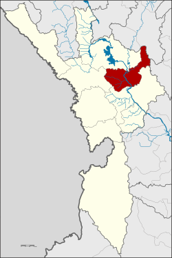
Ban Tak district
|
Ban Tak บ้านตาก |
|
|---|---|
| Province: | Tak |
| Surface: | 992.495 km² |
| Residents: | 45,429 (2012) |
| Population density : | 47 U / km² |
| ZIP : | 63120 |
| Geocode : | 6302 |
| map | |

|
|
Amphoe Ban Tak ( Thai : อำเภอ บ้านตาก ) is a district ( amphoe - administrative district) in the province of Tak . The Tak Province is located in the northern region of Thailand .
geography
Ban Tak County is located in northeast Tak Province, about 20 kilometers north of Tak City, and borders two other provinces, Sukhothai and Lampang .
The main building of the Amphoe Administration is in Ban Tak Ok, Tambon Tak Ok, on the west side of the Phahonyothin Highway.
Amphoe Ban Tak is located in the north-west of Tak Province and, when viewed clockwise from the south, borders the Amphoe Mueang Tak , Mae Ramat and Sam Ngao in the Province of Tak, Amphoe Thoen in the Province of Lampang and Amphoe Ban Dan Lan Hoi in the Province of Sukhothai .
Mae Nam Ping and Mae Nam Wang are important water sources for agricultural use in the county . Due to the mountain location facing away from the southwest monsoon, the climate of Ban Tak is rather dry and hot.
history
The old Tak ( Müang Tak), a north-western border town on the Mae Nam Ping (Ping River) in Ban Tha Phra That, Tambon Ko Taphao, was originally in the area of Ban Tak . King Maha Thammaracha of Ayutthaya relocated the center of Mueang Tak in the 16th century to its current location in Tambon Pa Mamuang.
In 2003 archaeologists discovered around 50 fossilized trees (Makha, Caesalpiniaceae family ) on aerial photographs , which were scattered over an area of around 35 km². The length of the largest fossil tree is more than 70 meters and its age is estimated to be almost a million years. The surrounding forest was then declared a forest protection zone and named "Petrified Wood Forest Park".
Attractions
- Wat Phra Boromthat (Thai: วัด พระบรม ธาตุ )
administration
Provincial Administration
Amphoe Ban Tak consists of seven sub-districts ( tambon ), which are further divided into 67 villages ( muban ).
There are two small towns ( Thesaban Tambon ) in the county:
- Ban Tak (Thai: เทศบาล ตำบล บ้านตาก ) consists of parts of the Tambon Tak Ok and Tak Tok,
- Thung Kra Chao (Thai: เทศบาล ตำบล ทุ่ง กระ เชาะ ) consists of parts of the Tambon Thong Fa.
There are also six “Tambon Administrative Organizations” (TAO, องค์การ บริหาร ส่วน ตำบล - administrative organizations) in the district.
| No. | Surname | Thai | Villages | Pop. |
|---|---|---|---|---|
| 1. | Tak ok | ตาก ออก | 12 | 10,552 |
| 2. | Samo Khon | สมอ โคน | 9 | 4,348 |
| 3. | Mae Salit | แม่ สลิด | 12 | 7,891 |
| 4th | Tak Tok | ตาก ตก | 10 | 5,596 |
| 5. | Ko Taphao | เกาะ ตะเภา | 8th | 6,359 |
| 6th | Thung Kracho | ทุ่ง กระ เชาะ | 9 | 5,583 |
| 7th | Thong Fa | ท้องฟ้า | 7th | 5,100 |
Local administration
There are two small towns ( Thesaban Tambon ) in the county:
- Ban Tak ( เทศบาล ตำบล บ้านตาก ) consists of parts of the Tambon Tak Ok and Tak Tok,
- Thung Kra Chao ( เทศบาล ตำบล ทุ่ง กระ เชาะ ) consists of parts of the Tambon Thong Fa.
There are also six "Tambon Administrative Organizations" (TAO, องค์การ บริหาร ส่วน ตำบล - administrative organizations) for the tambon in the district that do not belong to any city.
Individual evidence
- ↑ Population statistics 2012 . Department of Provincial Administration. Retrieved June 24, 2014.
Web links
Coordinates: 17 ° 3 ' N , 99 ° 5' E

