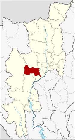
Mae Wang district
|
Mae Wang แม่ วาง |
|
|---|---|
| Province: | Chiang Mai |
| Surface: | 601.680 km² |
| Residents: | 31,325 (2013) |
| Population density : | 51.3 U / km² |
| ZIP : | 50360 |
| Geocode : | 5022 |
| map | |

|
|

Amphoe Mae Wang (in Thai : อำเภอ แม่ วาง ) is a district ( Amphoe - administrative district) in the central part of Chiang Mai Province . Chiang Mai Province is located in the northern region of Thailand .
geography
Neighboring counties (clockwise from south): Doi Lo , Chom Thong , Mae Chaem , Samoeng , Hang Dong and San Pa Tong district of Chiang Mai Province.
The landscape is mostly mountainous. Doi Inthanon , the highest mountain in Thailand at 2565 meters, forms the south-westernmost point of the district .
history
Mae Wang was founded on April 1, 1990 as a "branch circle" ( King Amphoe ) , consisting of the four tambon Ban Kat, Thung Pi, Thung Ruang Thong and Mae Win, which were split off from the Amphoe San Pa Tong . On September 7, 1995, Mae Wang received full Amphoe status.
administration
Provincial Administration
Mae Wang County is divided into five tambon ("subdistricts" or "parishes"), which are further subdivided into 58 muban ("villages").
| No. | Surname | Thai | Muban | Pop. |
|---|---|---|---|---|
| 1. | Ban cat | บ้าน กาด | 9 | 5,542 |
| 2. | Thung Pi | ทุ่ง ปี๊ | 12 | 4,351 |
| 3. | Thung Ruang Thong | ทุ่ง รวง ทอง | 8th | 2,447 |
| 4th | Mae Win | แม่ วิน | 19th | 11,873 |
| 5. | Don Pao | ดอน เปา | 10 | 7.112 |
Local administration
There is one municipality with "small town" status ( Thesaban Tambon ) in the district:
- Mae Wang (Thai: เทศบาล ตำบล แม่ วาง ) consisting of the parts of the Tambon Ban Kat, Don Pao.
There are also five " tambon administration organizations " ( องค์การ บริหาร ส่วน ตำบล - Tambon Administrative Organizations, TAO)
- Ban Kat (Thai: องค์การ บริหาร ส่วน ตำบล บ้าน กาด ) consisting of parts of the Tambon Ban Kat.
- Thung Pi (Thai: องค์การ บริหาร ส่วน ตำบล ทุ่ง ปี๊ ) consisting of the complete tambon Thung Pi.
- Thung Ruang Thong (Thai: องค์การ บริหาร ส่วน ตำบล ทุ่ง รวง ทอง ) consisting of the complete tambon Thung Ruang Thong.
- Mae Win (Thai: องค์การ บริหาร ส่วน ตำบล แม่ วิน ) consisting of the complete tambon Mae Win.
- Don Pao (Thai: องค์การ บริหาร ส่วน ตำบล ดอน เปา ) consisting of parts of the Tambon Don Pao.
Individual evidence
- ↑ ประกาศ กระทรวง มหาดไทย เรื่อง แบ่ง เขต ท้องที่ อำเภอ สันป่าตอง จังหวัด เชียงใหม่ ตั้ง เป็น กิ่ง อำเภอ แม่ วาง Royal Gazette Volume 107, Ed. 25 ง of February 13, 1990, p. 1349 (in Thai)
- ↑ พระราชกฤษฎีกา ตั้ง อำเภอ ด่าน มะขาม เตี้ย อำเภอ แก่ง หาง แมว อำเภอ ภักดี ชุมพล อำเภอ เวียง แก่น อำเภอ แม่ วาง อำเภอ ถ้ำ พรรณ รา อำเภอ บ่อ เกลือ อำเภอ อำเภอ โนน สุวรรณ อำเภอ ห้วย ราช อำเภอ แม่ ลาน อำเภอ บางแก้ว อำเภอ ป่า พะยอม อำเภอ หนอง ม่วง ไข่ สุ ราช สี สี สี สี สี สี สี อำเภอ จัง หาร อำเภอ บ้าน ธิ อำเภอ ภู สิงห์ อำเภอ บาง กล่ำ อำเภอ วัง ม่วง และ อำเภอ นา ยูง พ.ศ. ๒๕๓๘ Royal Gazette Volume 112, Ed. 32 ก August 8, 1995, pp. 1–3 (in Thai)
- ↑ 2013 population statistics ( Thai ) Department of Provincial Administration. Retrieved October 25, 2014.
Web links
Coordinates: 18 ° 37 ' N , 98 ° 47' E
