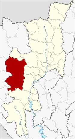
Mae Chaem district
|
Mae Chaem แม่แจ่ม |
|
|---|---|
| Province: | Chiang Mai |
| Surface: | 3,361,151 km² |
| Residents: | 58,321 (2013) |
| Population density : | 19.8 U / km² |
| ZIP : | 50270 |
| Geocode : | 5003 |
| map | |

|
|

Amphoe Mae Chaem (in Thai : อำเภอ แม่แจ่ม ) is a district ( Amphoe - administrative district) in the west of Chiang Mai Province . Chiang Mai Province is located in the northern region of Thailand .
geography
Neighboring counties (clockwise from the east): Samoeng , Mae Wang , Chom Thong and Hot district of Chiang Mai Province, Mae Sariang , Mae La Noi , Khun Yuam , Mueang Mae Hong Son and Pai of Mae Hong Son Province .
The elevation above sea level in Mae Chaem is between 282 and 2,565 meters. The highest point, Doi Inthanon , is also the highest mountain in Thailand. The great differences in altitude within Mae Chaem result in several different climatic zones with different vegetation. Below 1,000 meters in height, wing fruit plants (dipterocarp) with mixed forest predominate , between 900 and 1,500 meters in height tropical pine forest grows alternating with evergreen forest, which grows up to a height of 2,000 meters. There is a tropical cloud forest over 2,000 meters . Steep slopes with inclines of up to 25% are not uncommon and promote soil erosion . The soil is therefore only able to store water to a very limited extent. The Mae Chaem River is a tributary of the Mae Nam Ping and is an important source of water.
history
In 1908 the district of Mueang Chaem was founded consisting of the Tambon Mae Thap, Tha Pha, Chang Khoeng and Mae Suek, which were split off from Chom Thong . In 1917 the district was renamed Chang Khoeng because the main administration was based in this tambon. In 1938 the district was downgraded to a "branch district" ( King Amphoe ) and again subordinated to the Amphoe Chom Thong. In 1939 this "branch circle" was renamed Mae Chaem and in 1956 it was given full Amphoe status again.
In 2009 the northern part of the district was separated. It became the new district of Galyani Vadhana.
administration
Provincial Administration
Mae Chaem County is divided into seven tambon ("subdistricts" or "parishes"), which are further subdivided into 104 Muban ("villages").
| No. | Surname | Thai | Muban | Pop. |
|---|---|---|---|---|
| 1. | Chang Khoeng | ช่าง เคิ่ ง | 19th | 10,848 |
| 2. | Tha Pha | ท่า ผา | 10 | 4,950 |
| 3. | Ban Thap | บ้าน ทับ | 13 | 6.216 |
| 4th | Mae Suek | แม่ ศึก | 17th | 12.121 |
| 5. | Mae Na Chon | แม่ นา จร | 19th | 10,612 |
| 7th | Pang Hin Fon | ปาง หิน ฝน | 14th | 7.014 |
| 8th. | Kong Khaek | กอง แขก | 12 | 6,560 |
Local administration
There are two municipalities with "small town" status ( Thesaban Tambon ) in the district:
- Tha Pha (Thai: เทศบาล ตำบล ท่า ผา ) consisting of the complete Tambon Tha Pha.
- Mae Chaem (Thai: เทศบาล ตำบล แม่แจ่ม ) consisting of parts of the Tambon Chang Khoeng.
In addition, there are six " tambon administration organizations " ( องค์การ บริหาร ส่วน ตำบล - Tambon Administrative Organizations, TAO)
- Chang Khoeng (Thai: องค์การ บริหาร ส่วน ตำบล ช่าง เคิ่ ง ) consisting of parts of the Tambon Chang Khoeng.
- Ban Thap (Thai: องค์การ บริหาร ส่วน ตำบล บ้าน ทับ ) consisting of the complete tambon Ban Thap.
- Mae Suek (Thai: องค์การ บริหารส่วน ตำบล แม่ ศึก ) consisting of the complete tambon Mae Suek.
- Mae Na Chon (Thai: องค์การ บริหาร ส่วน ตำบล แม่ นา จร ) consisting of the complete tambon Mae Na Chon.
- Pang Hin Fon (Thai: องค์การ บริหาร ส่วน ตำบล ปาง หิน ฝน ) consisting of the complete Tambon Pang Hin Fon.
- Kong Khaek (Thai: องค์การ บริหาร ส่วน ตำบล กอง แขก ) consisting of the complete tambon Kong Khaek.
Individual evidence
- ↑ แจ้ง ความ กระทรวง มหาดไทย Royal Gazette Volume 25, Issue 15 of July 4, 1908, pp. 447–448 (in Thai)
- ↑ ประกาศ กระทรวง มหาดไทย เรื่อง เปลี่ยน ชื่อ อำเภอ Royal Gazette Volume 34, Ed. 0 ก of April 29, 1917, pp. 40–68 (in Thai)
- ↑ ประกาศ สำนัก นายกรัฐมนตรี เรื่อง ยุบ อำเภอ ลง เป็น กิ่ง อำเภอ Royal Gazette Volume 55, Ed. 0 ง of September 12, 1938, p. 2067 (in Thai)
- ↑ พระราชกฤษฎีกา เปลี่ยน นาม อำเภอ กิ่ง อำเภอ และ ตำบล บาง แห่ง พุทธศักราช ๒๔๘๒ Royal Gazette Volume 56, Ed. 0 ก of April 17, 1939, pp. 354–364 (in Thai)
- ↑ พระราชกฤษฎีกา จัดตั้ง อำเภอ นาทวี อำเภอ สะบ้าย้อย อำเภอ คำชะอี อำเภอ ย่านตาขาว อำเภอ วัดโบสถ์ อำเภอ หนองบัว อำเภอ วัฒนานคร อำเภอ แสวงหา อำเภอ ท่าชนะ อำเภอ พระพุทธบาท อำเภอ โนนสัง อำเภอ อำเภอ บำเหน็จณรงค์ อำเภอ คอนสวรรค์ อำเภอ บ้านโฮ่ง บ้านโฮ่ง อำเภอ คีรีมาศ อำเภอ ชนแดน อำเภอ แม่แจ่ม อำเภอ ไทรน้อย และ อำเภอ บ้านแพง พ.ศ. ๒๔๙๙ Royal Gazette Volume 73, ed. 46 ก June 5, 1956, pp. 657–661 (in Thai)
- ↑ พระราชกฤษฎีกา ตั้ง อำเภอ กัลยา ณิ วัฒนา จังหวัด เชียงใหม่ พ.ศ. ๒๕๕๒ . In: Royal Gazette . 126, No. 97 ก , December 25, 2009, pp. 7–9.
- ↑ 2013 population statistics ( Thai ) Department of Provincial Administration. Retrieved October 25, 2014.
Web links
Coordinates: 18 ° 30 ' N , 98 ° 22' E

