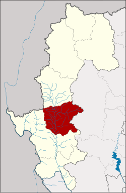
Mae La Noi district
|
Mae La Noi แม่ลาน้อย |
|
|---|---|
| Province: | Mae Hong Son |
| Surface: | 1,456.6 km² |
| Residents: | 35,343 (2013) |
| Population density : | 23.4 U / km² |
| ZIP : | 58120 |
| Geocode : | 5805 |
| map | |

|
|

Amphoe Mae La Noi (in Thai อำเภอ แม่ลาน้อย ) is a district ( amphoe - administrative district) of Mae Hong Son Province . The Mae Hong Son Province is located in the northern region of Thailand .
geography
Neighboring districts (from southwest clockwise): Mae Sariang District in Mae Hong Son Province , the Kayah State of Myanmar , Khun Yuam District in Mae Hong Son Province and Mae Chaem District in Chiang Mai Province .
Major rivers in the county are the Maenam Yuam ( Yuam River ), Maenam Mae La Luang ( Mae La Luang River ), and Maenam Mae La Noi ( Mae La Noi River ).
history
Mae La Noi was initially set up on February 10, 1967 as a "branch circle" ( King Amphoe ) , which at the time consisted of the two tambon Mae La Noi and Mae La Luang. It was placed under the responsibility of the Mae Sariang Amphoe , from which the Mae La Noi tambon had been separated. Mae La Luang originally belonged to the Amphoe Khun Yuam . Mae La Noi was promoted to Amphoe on August 21, 1975.
administration
Provincial Administration
Mae La Noi County is divided into eight tambon ("subdistricts" or "parishes"), which are further subdivided into 69 muban ("villages").
| No. | Surname | Thai | Muban | Pop. |
|---|---|---|---|---|
| 1. | Mae La Noi | แม่ลาน้อย | 15th | 9,405 |
| 2. | Mae La Luang | แม่ ลา หลวง | 9 | 5,210 |
| 3. | Tha Pha Pum | ท่า ผา ปุ้ม | 8th | 3,849 |
| 4th | Mae Tho | แม่ โถ | 8th | 3,587 |
| 5. | Huai Hom | ห้วย ห้อม | 9 | 4,441 |
| 6th | Mae Na Chang | แม่ นา จาง | 7th | 3,293 |
| 7th | Santi Khiri | สันติ คีรี | 8th | 2,675 |
| 8th. | Khun Mae La Noi | ขุน แม่ลาน้อย | 5 | 2,883 |
Local administration
There is one municipality with "small town" status ( Thesaban Tambon ) in the district:
- Mae La Noi (Thai: เทศบาล ตำบล แม่ลาน้อย ) consisting of parts of the Mae La Noi tambon.
In addition, there are eight " tambon administration organizations " ( องค์การ บริหาร ส่วน ตำบล - Tambon Administrative Organizations, TAO)
- Mae La Noi (Thai: องค์การ บริหาร ส่วน ตำบล แม่ลาน้อย ) consisting of parts of the Tambon Mae La Noi.
- Mae La Luang (Thai: องค์การ บริหาร ส่วน ตำบล แม่ ลา หลวง ) consisting of the complete tambon Mae La Luang.
- Tha Pha Pum (Thai: องค์การ บริหาร ส่วน ตำบล ท่า ผา ปุ้ม ) consisting of the complete tambon Tha Pha Pum.
- Mae Tho (Thai: องค์การ บริหาร ส่วน ตำบล แม่ โถ ) consisting of the complete tambon Mae Tho.
- Huai Hom (Thai: องค์การ บริหาร ส่วน ตำบล ห้วย ห้อม ) consisting of the complete tambon Huai Hom.
- Mae Na Chang (Thai: องค์การ บริหาร ส่วน ตำบล แม่ นา จาง ) consisting of the complete tambon Mae Na Chang.
- Santi Khiri (Thai: องค์การ บริหาร ส่วน ตำบล สันติ คีรี ) consisting of the complete tambon Santi Khiri.
- Khun Mae La Noi (Thai: องค์การ บริหาร ส่วน ตำบล ขุน แม่ลาน้อย ) consisting of the complete tambon Khun Mae La Noi.
Individual evidence
- ↑ ประกาศ กระทรวง มหาดไทย เรื่อง แบ่ง ท้องที่ ตั้ง เป็น กิ่ง อำเภอ . In: Royal Gazette . 84, No. 16 ง ฉบับ พิเศษ (special), February 15, 1967, p. 4. " แบ่ง ท้องที่ อำเภอ แม่สะเรียง ตั้ง เป็น กิ่ง อำเภอ แม่ลาน้อย "
- ↑ พระราชกฤษฎีกา เปลี่ยนแปลง เขต อำเภอ ขุนยวม และ กิ่ง อำเภอ แม่ลาน้อย อำเภอ แม่สะเรียง จังหวัด แม่ฮ่องสอน พ.ศ. ๒๕๑๐ . In: Royal Gazette . 84, No. 114 ก ฉบับ พิเศษ (special), February 23, 1967, pp. 29-30.
- ↑ พระราชกฤษฎีกา ตั้ง อำเภอ แวงน้อย อำเภอ ป่าแดด อำเภอ เรณูนคร อำเภอ คูเมือง อำเภอ คุระบุรี อำเภอ แม่ลาน้อย อำเภอ เสริมงาม อำเภอ อำเภอ ไพรบึง และ อำเภอ หนองโดน พ.ศ. ๒๕๑๘ . In: Royal Gazette . 92, No. 166 ก ฉบับ พิเศษ (special), August 21, 1975, pp. 1-4.
- ↑ 2013 population statistics ( Thai ) Department of Provincial Administration. Retrieved August 9, 2014.
Web links
Coordinates: 18 ° 23 ′ 2.9 ″ N , 97 ° 56 ′ 13 ″ E

