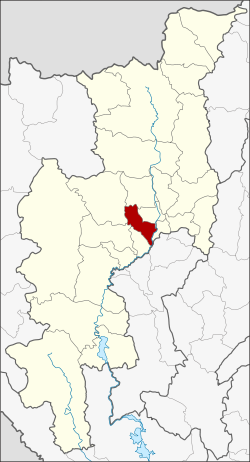
Hang Dong district
|
Hang dong หางดง |
|
|---|---|
| Province: | Chiang Mai |
| Surface: | 277.1 km² |
| Residents: | 81,635 (2013) |
| Population density : | 243.8 U / km² |
| ZIP : | 50230, 50340 |
| Geocode : | 5015 |
| map | |

|
|

Amphoe Hang Dong (in Thai : อำเภอ หางดง ) is a district ( Amphoe - administrative district) in Chiang Mai Province . Chiang Mai Province is located in the northern region of Thailand .
geography
The district is located southwest of the city of Chiang Mai.
Neighboring districts (from southwest clockwise): the Amphoe San Pa Tong , Mae Wang , Samoeng , Mae Rim , Mueang Chiang Mai and Saraphi of Chiang Mai Province, and Amphoe Mueang Lamphun of Lamphun Province .
Attractions
- Wat Ton Kwen (Thai: วัด ต้น เก ว๋ น ) - Small temple in the middle of rice fields in a unique Lan-Na design, built around 1858.
Wihan of Wat Ton Kwen
administration
Provincial Administration
Hang Dong County is divided into eleven tambon ("subdistricts" or "communities"), which are further subdivided into 109 muban ("villages").
| No. | Surname | Thai | Muban | Pop. |
|---|---|---|---|---|
| 1. | Hang dong | หางดง | 9 | 9,483 |
| 2. | Nong Kaeo | หนอง แก๋ ว | 9 | 5,346 |
| 3. | Han Kaeo | หาร แก้ว | 9 | 5,779 |
| 4th | Nong Tong | หนอง ตอง | 14th | 8,759 |
| 5. | Khun Khong | ขุน คง | 9 | 5,014 |
| 6th | Sop Mae Kha | สบ แม่ ข่า | 5 | 2,452 |
| 7th | Ban Waen | บ้าน แหวน | 13 | 10,319 |
| 8th. | San Phak Wan | สัน ผักหวาน | 7th | 12,525 |
| 9. | Nong Khwai | หนอง ควาย | 12 | 10,218 |
| 10. | Ban pong | บ้าน ป ง | 11 | 5,165 |
| 11. | Nam Phrae | น้ำ แพร่ | 11 | 6,575 |
Local administration
There are ten municipalities with "small town" status ( Thesaban Tambon ) in the district:
- Mae Tha Chang (Thai: เทศบาล ตำบล แม่ ท่าช้าง ) consisting of parts of the Tambon Hang Dong.
- Nong Kaeo (Thai: เทศบาล ตำบล หนอง แก๋ ว ) consisting of the complete Tambon Nong Kaeo.
- Han Kaeo (Thai: เทศบาล ตำบล หาร แก้ว ) consisting of the complete tambon Han Kaeo.
- Ban Waen (Thai: เทศบาล ตำบล บ้าน แหวน ) consisting of the complete tambon Ban Waen.
- San Phak Wan (Thai: เทศบาล ตำบล สัน ผักหวาน ) consisting of the complete Tambon San Phak Wan.
- Nong Khwai (Thai: เทศบาล ตำบล หนอง ควาย ) consisting of the complete Tambon Nong Khwai.
- Ban Pong (Thai: เทศบาล ตำบล บ้าน ป ง ) consisting of the complete Tambon Ban Pong.
- Nam Phrae Phatthana (Thai: เทศบาล ตำบล น้ำ แพร่ พัฒนา ) consisting of the complete Tambon Nam Phrae.
- Nong Tong Phatthana (Thai: เทศบาล ตำบล หนอง ตอง พัฒนา ) consisting of the complete Tambon Nong Tong.
- Hang dong (Thai: เทศบาล ตำบล หางดง ) consisting of parts of the tambon hang dong.
There are also two " tambon administration organizations " ( องค์การ บริหาร ส่วน ตำบล - Tambon Administrative Organizations, TAO)
- Khun Khong (Thai: องค์การ บริหาร ส่วน ตำบล ขุน คง ) consisting of the complete Tambon Khun Khong.
- Sop Mae Kha (Thai: องค์การ บริหาร ส่วน ตำบล สบ แม่ ข่า ) consisting of the complete tambon Sop Mae Kha.
Individual evidence
- ↑ 2013 population statistics ( Thai ) Department of Provincial Administration. Retrieved October 25, 2014.
Web links
Coordinates: 18 ° 41 ′ N , 98 ° 55 ′ E


