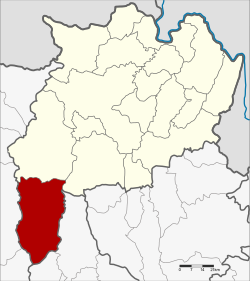
Wiang Pa Pao district
|
Wiang Pa Pao เวียงป่าเป้า |
|
|---|---|
| Province: | Chiang Rai |
| Surface: | 1217.0 km² |
| Residents: | 67,236 (2013) |
| Population density : | 56.2 U / km² |
| ZIP : | 57170, 57260 |
| Geocode : | 5711 |
| map | |

|
|
Amphoe Wiang Pa Pao ( Thai : อำเภอ เวียงป่าเป้า , pronunciation: ʔāmpʰɤ̄ː wīaŋ pàː pâw ) is a district ( Amphoe - administrative district) in the southwest of Chiang Rai Province . Chiang Rai Province is located in the far north of the northern region of Thailand .
geography
Neighboring districts are (from the north clockwise) Mae Suai District and Phan Chiang Rai province, Wang Nuea and Mueang Pan of Lampang Province , and Doi Saket and Phrao of Chiang Mai Province .
history
Wiang Pa Pao was one of the numerous Mueang in northern Thailand. In 1905, the Wiang Pa Pao district was merged with Mueang Phong and renamed Mae Suai, while the central area of the old Mueang kept the name of the "branch circle" ( King Khwaeng ) Wiang Pa Pao. In 1907 Wiang Pa Pao was granted full amphoe status.
Attractions
-
National parks :
- Khun Chae National Park ( อุทยานแห่งชาติ ขุน แจ ) - the 270 km² park was opened in 1995. It takes its name from the Khun Chae waterfall ( น้ำตก ขุน แจ ). Also worth seeing: the 2,031 meter high Doi Langka ( ดอย ลังกา ), Thailand's fifth highest mountain and the forest nature trail on Doi Mot ( ดอย มด ).
administration
Provincial Administration
The district of Wiang Pa Pao is divided into seven tambon ("subdistricts" or "municipalities"), which are further subdivided into 93 muban ("villages").
| No. | Surname | Thai | Muban | Pop. |
|---|---|---|---|---|
| 1. | San Sali | สัน ส ลี | 13 | 9,242 |
| 2. | Wiang | เวียง | 12 | 15,250 |
| 3. | Ban pong | บ้านโป่ง | 7th | 5,229 |
| 4th | Pa Ngio | ป่า งิ้ว | 16 | 9.113 |
| 5. | Wiang Kalong | เวียง กาหลง | 15th | 9,344 |
| 6th | Mae Chedi | แม่ เจดีย์ | 16 | 9,466 |
| 7th | Mae Chedi Mai | แม่ เจดีย์ ใหม่ | 14th | 9,592 |
Local administration
There are four municipalities with "small town" status ( Thesaban Tambon ) in the district:
- Pa Ngio (Thai: เทศบาล ตำบล ป่า งิ้ว ) consisting of the complete tambon Pa Ngio.
- Wiang Kalong (Thai: เทศบาล ตำบล เวียง กาหลง ) consisting of the complete tambon Wiang Kalong.
- Mae Khachan (Thai: เทศบาล ตำบล แม่ ขะ จาน ) consisting of parts of the Tambon Mae Chedi.
- Wiang Pa Pao (Thai: เทศบาล ตำบล เวียงป่าเป้า ) consisting of parts of the tambon Wiang.
There are also five " tambon administration organizations " ( องค์การ บริหาร ส่วน ตำบล - Tambon Administrative Organizations, TAO)
- San Sali (Thai: องค์การ บริหาร ส่วน ตำบล สัน ส ลี ) consisting of the complete Tambon San Sali.
- Wiang (Thai: องค์การ บริหาร ส่วน ตำบล เวียง ) consisting of parts of the tambon Wiang.
- Ban Pong (Thai: องค์การ บริหาร ส่วน ตำบล บ้านโป่ง ) consisting of the complete Tambon Ban Pong.
- Mae Chedi (Thai: องค์การ บริหาร ส่วน ตำบล แม่ เจดีย์ ) consisting of parts of the Tambon Mae Chedi.
- Mae Chedi Mai (Thai: องค์การ บริหาร ส่วน ตำบล แม่ เจดีย์ ใหม่ ) consisting of the complete tambon Mae Chedi Mai.
Individual evidence
- ↑ แจ้ง ความ กระทรวง มหาดไทย เปลี่ยน ชื่อ แขวง แม่ กก เรียก แขวง เมือง เชียงราย กับ รวม แขวง เมือง พง แขวง เมือง เวียงป่าเป้า เรียก แขวง แม่ ซวย . (PDF) In: Royal Gazette . 22, No. 39, December 24, 1905, p. 950.
- ↑ แจ้ง ความ กระทรวง มหาดไทย เรื่อง ยก กิ่ง แขวง เวียง เป้า ขึ้น เป็น แขวง เวียงป่าเป้า อยู่ ใน ความ บังคับบัญชา ของ บริเวณ พายัพ เหนือ . (PDF) In: Royal Gazette . 24, No. 7, May 19, 1907, p. 161.
- ↑ 2013 population statistics ( Thai ) Department of Provincial Administration. Retrieved October 26, 2014.
Web links
- More information about the Amphoe Wiang Pa Pao from amphoe.com (in Thai)
- Information on Khun Chae National Park (in English)
Coordinates: 19 ° 21 ' N , 99 ° 30' E

