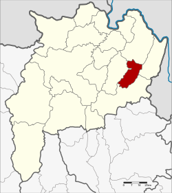
Amphoe Khun Tan
|
Khun Tan ขุน ตาล |
|
|---|---|
| Province: | Chiang Rai |
| Surface: | 234.0 km² |
| Residents: | 32,085 (2013) |
| Population density : | 143.1 U / km² |
| ZIP : | 57340 |
| Geocode : | 5714 |
| map | |

|
|

Amphoe Khun Tan (in Thai : อำเภอ ขุน ตาล , pronunciation: ʔāmpʰɤ̄ː kʰǔn tāːn ) is a district ( Amphoe - administrative district) in the east of Chiang Rai Province . Chiang Rai Province is located in the far north of the northern region of Thailand .
geography
Neighboring counties (clockwise from the west): Phaya Mengrai , Chiang Khong , Wiang Kaen and Thoeng in Chiang Rai Province.
history
Khun Tan was founded on April 1, 1992 as a "branch circle " ( King Amphoe ) , consisting of three municipalities ( tambon ) , which were split off from Thoeng County . On December 5, 1996, Khun Tan received full Amphoe status.
administration
Provincial Administration
The district of Khun Tan is divided into three tambon ("subdistricts" or "communities"), which are further subdivided into 55 muban ("villages").
| No. | Surname | Thai | Muban | Pop. |
|---|---|---|---|---|
| 1. | Ta | ต้า | 20th | 12,895 |
| 2. | Pa Tan | ป่า ตาล | 14th | 7,830 |
| 3. | Yang Hom | ยาง ฮ อม | 21st | 11,360 |
Local administration
There are three municipalities with "small town" status ( Thesaban Tambon ) in the district:
- Pa Tan (Thai: เทศบาล ตำบล ป่า ตาล ) consisting of the complete tambon Pa Tan.
- Ban Ta (Thai: เทศบาล ตำบล บ้าน ต้า ) consisting of parts of the Tambon Ta.
- Yang Hom (Thai: เทศบาล ตำบล ยาง ฮ อม ) consisting of the complete tambon Yang Hom.
There is also a " Tambon Administration Organization " ( องค์การ บริหาร ส่วน ตำบล - Tambon Administrative Organization, TAO)
- Ta (Thai: องค์การ บริหาร ส่วน ตำบล ต้า ) consisting of parts of the tambon Ta.
Individual evidence
- ↑ ประกาศ กระทรวง มหาดไทย เรื่อง แบ่ง เขต ท้องที่ อำเภอ เทิง จังหวัด เชียงราย ตั้ง เป็น กิ่ง อำเภอ ขุน ตาล . In: Royal Gazette . 109, No. 53 ง ฉบับ พิเศษ (special), April 22, 1992, p. 6.
- ↑ พระราชกฤษฎีกา ตั้ง อำเภอ เหนือ คลอง อำเภอ นา ยาย อาม อำเภอ ท่า ตะเกียบ อำเภอ ขุน ตาล อำเภอ แม่ ฟ้า หลวง อำเภอ แม่ ลาว อำเภอ รั ษ ฎา อำเภอ อำเภอ พุทธ มณฑล อำเภอ วัง วัง น้ำ เขียว อำเภอ เจาะ ไอ ร้อง อำเภอ ชำนิ อำเภอ โนน ดินแดง อำเภอ ปาง สนธิ อำเภอ อำเภอ อำเภอ อำเภอ อำเภอ อำเภอ อำเภอ หนอง ม่วง อำเภอ เบญจ ลัก ษ์ อำเภอ โพน นา แก้ว อำเภอ บุ่ง คล้า อำเภอ ดอน มดแดง และ อำเภอ ลือ อำนาจ พ.ศ. ๒๕๓๙ . In: Royal Gazette . 113, No. 62 ก , November 20, 1996, pp. 5-8.
- ↑ 2013 population statistics ( Thai ) Department of Provincial Administration. Retrieved October 26, 2014.
Web links
Coordinates: 19 ° 50 ′ N , 100 ° 16 ′ E
