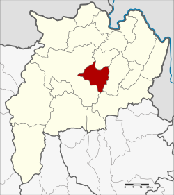
Wiang Chai district
|
Wiang Chai เวียงชัย |
|
|---|---|
| Province: | Chiang Rai |
| Surface: | 258.8 km² |
| Residents: | 44,449 (2013) |
| Population density : | 170.5 U / km² |
| ZIP : | 57210 |
| Geocode : | 5702 |
| map | |

|
|
Amphoe Wiang Chai ( Thai : อำเภอ เวียงชัย , pronunciation: ʔāmpʰɤ̄ː wīaŋ tɕʰāj ) is a district ( Amphoe - administrative district) in the central part of Chiang Rai Province . Chiang Rai Province is located in the far north of the northern region of Thailand .
geography
Neighboring counties (clockwise from west): Amphoe Mueang Chiang Rai , Wiang Chiang Rung , Phaya Mengrai and Thoeng of Chiang Rai Province.
An important river in the county is the Maenam Kok ( Kok River ) .
history
Wiang Chai was founded on June 17, 1974 as a "branch circle " ( King Amphoe ) , consisting of the three tambon Wiang Chai, Thung Ko and Pha Ngam, which were split off from the Mueang Chiang Rai district. On March 25, 1994, Wiang Chai received full amphoe status.
administration
Provincial Administration
The district of Wiang Chai is divided into five tambon ("subdistricts" or "communities"), which are further divided into 75 muban ("villages").
| No. | Surname | Thai | Muban | Pop. |
|---|---|---|---|---|
| 2. | Wiang Chai | เวียงชัย | 20th | 11,515 |
| 3. | Pha Ngam | ผา งาม | 15th | 9,062 |
| 4th | Wiang Nuea | เวียง เหนือ | 12 | 6,634 |
| 6th | Don Sila | ดอน ศิลา | 17th | 9,901 |
| 8th. | Mueang Chum | เมือง ชุม | 11 | 7,337 |
Note: The missing numbers refer to tambon, which now form the Wiang Chiang Rung district.
Local administration
There are five municipalities with "small town" status ( Thesaban Tambon ) in the district:
- Siri Wiang Chai (Thai: เทศบาล ตำบล สิริ เวียงชัย ) consisting of parts of the Tambon Wiang Chai.
- Wiang Nuea (Thai: เทศบาล ตำบล เวียง เหนือ ) consisting of the complete tambon Wiang Nuea.
- Don Sila (Thai: เทศบาล ตำบล ดอน ศิลา ) consisting of the complete tambon Don Sila.
- Mueang Chum (Thai: เทศบาล ตำบล เมือง ชุม ) consisting of parts of the Tambon Mueang Chum.
- Wiang Chai (Thai: เทศบาล ตำบล เวียงชัย ) consisting of the parts of the tambon Wiang Chai, Mueang Chum.
There is also a " Tambon Administration Organization " ( องค์การ บริหาร ส่วน ตำบล - Tambon Administrative Organization, TAO)
- Pha Ngam (Thai: องค์การ บริหาร ส่วน ตำบล ผา งาม ) consisting of the complete tambon Pha Ngam.
Individual evidence
- ↑ ประกาศ กระทรวง มหาดไทย เรื่อง แบ่ง ท้องที่ อำเภอ เชียงราย จังหวัด เชียงราย ตั้ง เป็น กิ่ง อำเภอ เวียงชัย . In: Royal Gazette . 91, No. 100 ง , June 11, 1974, p. 2589.
- ↑ พระราชกฤษฎีกา ตั้ง อำเภอ หนองกุงศรี อำเภอ ไทรงาม อำเภอ บ้านฝาง อำเภอ อุบลรัตน์ อำเภอ เวียงชัย อำเภอ ดอยเต่า อำเภอ นิคมคำสร้อย อำเภอ นาหว้า อำเภอ เสิงสาง อำเภอ ศรีสาคร อำเภอ บึงสามพัน อำเภอ นาดูน อำเภอ อำเภอ ค้อวัง อำเภอ โพธิ์ชัย อำเภอ อำเภอ เมืองสรวง อำเภอ ปลวกแดง อำเภอ ยางชุมน้อย อำเภอ กาบเชิง อำเภอ สุวรรณคูหา และ อำเภอ กุดข้าวปุ้น พ.ศ. ๒๕๒๒ . In: Royal Gazette . 96, No. 42 ก ฉบับ พิเศษ (Special), March 25, 1979, pp. 19-24.
- ↑ 2013 population statistics ( Thai ) Department of Provincial Administration. Retrieved October 26, 2014.
Web links
Coordinates: 19 ° 53 ' N , 99 ° 56' E
