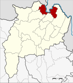
Chiang Saen Amphoe
|
Chiang Saen เชียงแสน |
|
|---|---|
| Province: | Chiang Rai |
| Surface: | 554.0 km² |
| Residents: | 50,210 (2013) |
| Population density : | 93.8 U / km² |
| ZIP : | 57150 |
| Geocode : | 5708 |
| map | |

|
|
Amphoe Chiang Saen ( Thai : อำเภอ เชียงแสน , pronunciation: ʔāmpʰɤ̄ː tɕʰīaŋ sɛ̌ːn ) is a district ( Amphoe - administrative district) in the north of Chiang Rai Province . Chiang Rai Province is located in the far north of the northern region of Thailand . The district capital is also called Chiang Saen .
geography
Neighboring counties (clockwise from east): Chiang Khong District , Doi Luang , Mae Chan and Mae Sai of Chiang Rai Province. In the north, Chiang Saen shares a border with the Shan state of Myanmar and with the Lao province of Bokeo .
The area where the Ruak River meets the Mekong is known as the Golden Triangle . The border region of the three states Thailand, Myanmar and Laos is now a popular destination for tourists.
history
Excavations show that the area on the banks of the Mekong was already populated in prehistoric times. There are only sparse sources about the time before the 12th century, the kingdom of Ngoen Yang is said to have existed here. At the time of King Mengrai , Chiang Saen became an important city ( mueang ) in the kingdom of Lan Na .
During the reign of Rama I , Chao Kawila of Chiangmai conquered the city to free Lan Na from the rule of the Burmese . As a result, Chiang Saen fell into disrepair as its residents were relocated to other cities.
Today the ruins of numerous Buddhist temples can be seen here, such as Wat Pa Sak with a well-preserved chedi .
At the beginning of the 20th century, the city of Chiang Saen was converted into a district, which also contained a "branch district" of the same name ( King Amphoe ) , consisting of the center. The subdistrict was dissolved in 1925. Two years later it was re-established under the name Chiang Saen Luang ( เชียงแสน หลวง ). In 1939 the subdistrict was renamed Chiang Saen, while the existing Chiang Saen county was renamed Mae Chan . On April 6, 1957, the subdistrict was given full amphoe status.
administration
Provincial Administration
Chiang Saen County is divided into six tambon ("subdistricts" or "parishes"), which are further subdivided into 70 muban ("villages").
| No. | Surname | Thai | Muban | Pop. |
|---|---|---|---|---|
| 1. | Wiang | เวียง | 9 | 11,502 |
| 2. | Pa Sak | ป่า สัก | 13 | 7,674 |
| 3. | Ban Saeo | บ้าน แซว | 15th | 10,568 |
| 4th | Si Don Mun | ศรี ดอน มูล | 13 | 7,584 |
| 5. | Mae Ngoen | แม่ เงิน | 12 | 8,238 |
| 6th | Yonok | โยนก | 8th | 4,644 |
Local administration
There are five municipalities with "small town" status ( Thesaban Tambon ) in the district:
- Wiang (Thai: เทศบาล ตำบล เวียง ) consisting of parts of the tambon Wiang.
- Ban Saeo (Thai: เทศบาล ตำบล บ้าน แซว ) consisting of the complete tambon Ban Saeo.
- Mae Ngoen (Thai: เทศบาล ตำบล แม่ เงิน ) consisting of the complete tambon Mae Ngoen.
- Yonok (Thai: เทศบาล ตำบล โยนก ) consisting of the complete tambon yonok.
- Wiang Chiang Saen (Thai: เทศบาล ตำบล เวียง เชียงแสน ) consisting of parts of the tambon Wiang.
There are also two " tambon administration organizations " ( องค์การ บริหาร ส่วน ตำบล - Tambon Administrative Organizations, TAO)
- Pa Sak (Thai: องค์การ บริหาร ส่วน ตำบล ป่า สัก ) consisting of the complete tambon Pa Sak.
- Si Don Mun (Thai: องค์การ บริหาร ส่วน ตำบล ศรี ดอน มูล ) consisting of the complete tambon Si Don Mun.
Individual evidence
- ↑ Michael Freeman: Lanna - Thailand's Northern Kingdom . River Books, Bangkok 2001, ISBN 0-50097602-3
- ↑ See also: Mandala (political model)
- ↑ แจ้ง ความ กระทรวง มหาดไทย เรื่อง ยุบ กิ่ง เชียงแสน เข้า รวม กับ อำเภอ เชียงแสน จังหวัด เชียงราย . In: Royal Gazette . 42, No. 0 ง , October 4, 1925, p. 2159.
- ↑ แจ้ง ความ กระทรวง มหาดไทย เรื่อง ตั้ง กิ่ง อำเภอ เชียงแสน หลวง . In: Royal Gazette . 44, No. 0 ง , July 17, 1927, p. 1232.
- ↑ พระราชกฤษฎีกา เปลี่ยน นาม อำเภอ กิ่ง อำเภอ และ ตำบล บาง แห่ง พุทธศักราช ๒๔๘๒ . In: Royal Gazette . 56, No. 0 ก , April 17, 1939, pp. 354-364.
- ↑ พระราชกฤษฎีกา ตั้ง อำเภอ เชียงแสน พ.ศ. ๒๕๐๐ . In: Royal Gazette . 74, No. 36 ก , April 6, 1957, pp. 565-567.
- ↑ 2013 population statistics ( Thai ) Department of Provincial Administration. Retrieved October 26, 2014.
Web links
- More information on Amphoe Chiang Saen from amphoe.com (in Thai)
- Ornithology in Chiang Saen on thaibirding.com (in English)
- The Yonok Wetland near Chiang Saen (in English)
Coordinates: 20 ° 16 '31.3 " N , 100 ° 5' 15.5" E


