
National Road 13 (Laos)
| National Road 13 in Laos | |
|
|
|
|
|
|
| map | |
| Basic data | |
| Operator: | Ministry of Transport |
| Start of the street: |
Nateuy ( 21 ° 4 ′ N , 101 ° 39 ′ E ) |
| End of street: | Stung Treng border crossing ( 13 ° 55 ′ N , 106 ° 2 ′ E ) |
| Overall length: | 1346 km |
 |
|
| National road 13 | |
The National Road 13 is 1,346 km the longest and most economically important road in Laos . It runs from messengers on the Chinese border via Muang Xay , Luang Prabang , Vang Vieng , Vientiane , Pakxan , Thakhek , Xeno near Savannakhet and Pakse to Veun Kham on the Cambodian border. In southern Laos in particular, it mostly runs near the Mekong . Furthermore, this national road leads on all three international airports in Laos by: Vientiane Airport , Luang Prabang International Airport and Pakse . Between Boten and Nateuy, National Road 13 is a 20 km long part of the Kunming-Bangkok Expressway , which in turn is part of the Asian Highway AH3 . From Nateuy to Vientiane, national road 13 is part of AH12 , from Vientiane to Veun Kham part of AH11 .
photos

Border crossing to China with messengers
National Road 13 in Muang Xay

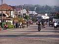
National Road 13 in Vang Vieng

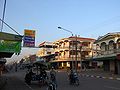
National Road 13 in Pakxan
National Road 13 in Savannakhet


