
Cần Thơ
| Cần Thơ | |||
|---|---|---|---|
| City seal : |
|
||
| Basic data | |||
| Country: |
|
||
| Region: | South Vietnam ( Nam Bộ ) | ||
| Region : | Mekong Delta | ||
| Province : | Cần Thơ | ||
| ISO 3166-2: VN : | VN-CT | ||
| Coordinates : | 10 ° 2 ' N , 105 ° 47' E | ||
| Area of the province: | 1408.9 km² | ||
| Waters : | Sông Hậu ( Bassac ), Sông Cần Thơ | ||
| population | |||
| Inhabitants province: | 1,238,300 (Statistical Yearbook 2014) |
||
| Population density : | 879 inhabitants per km² | ||
| Ethnic groups : | Kinh , Hoa , Cham , Khmer | ||
| Further information | |||
| Founding: | officially in 1739 as Trấn Giang | ||
| Post Code: | 90xxxx | ||
| Area code : | +84 (0) 710 | ||
| Vehicle registration number : | 65 | ||
| Time zone : | UTC +7: 00 | ||
| administration | |||
| Chairman of the People's Council: | Nguyễn Hữu Lợi | ||
| Chairman of the People's Committee: | Lê Hùng Dũng | ||
| Website: | www.cantho.gov.vn | ||

Cần Thơ ( ) is the largest city in the Mekong Delta region and the fourth largest city in Vietnam . As a city under direct government control, it is directly subordinate to the central government and on an equal footing with the provincial administrative unit . The "Thành phố Cần Thơ" has less the character of a grown city than that of an administrative unit made up of loosely connected settlements. The centrally located district (Quận) Ninh Kiều is the most populous with around 250,000 inhabitants; most of the city and municipal offices are located here. Tây Đô ("Capital of the West") is also known as the historical name for the city .
Geography & Climate
The city is located on the southern bank of the "Lower Mekong", the largest arm of the Mekong. In Vietnamese he is called Sông Hậu , in the Khmer language Tonle Bassac . Other Vietnamese names are Hậu Giang like the province of the same name or Sông Ba Thắc (“River of Three Questions”). On the southern outskirts of the village, the Sông Cần Thơ flows into the Sông Hậu. Through the urban area run u. a. the Thốt Nốt Canal, the Cái Khế Canal and the Ô Môn Canal.
Cần Thơ borders the provinces An Giang , Hậu Giang , Kiên Giang , Vĩnh Long and Đồng Tháp . The metropolis of southern Vietnam, Hồ-Chí-Minh-Stadt , formerly Saigon, is about 160 km northeast. The climate in Cần Thơ is tropical and monsoons : rain from May to November, dry from December to April. The mean humidity is 83 percent, the annual rainfall is 2024 mm and the mean temperature is 27.5 ° C.
|
Average monthly temperatures and precipitation for Cần Thơ
Source: Mapped Planet
|
||||||||||||||||||||||||||||||||||||||||||||||||||||||||||||||||||||||||||||||||||||||||||||||||||||||||||||||||||||||||
Administrative structure

The province of Cần Thơ has a checkered history as an administrative structure: At the time of the Nguyễn dynasty , Cần Thơ was the capital of the then An Giang province. When the French took the south-west of Vietnam in 1867 , they divided what was then An Giang into six new provinces: Châu Đốc, Long Xuyên, Sa Đéc, Cần Thơ, Sóc Trăng and Bạc Liêu.
On October 22, 1956, the then province of Cần Thơ became the new province of Phong Dinh with the capital Cần Thơ. In February 1976, the province of Hậu Giang was formed from the provinces of Phong Dinh, Ba Xuyên, Sóc Trăng and the city of Cần Thơ. This was divided on December 26, 1991 into the provinces of Cần Thơ and Sóc Trăng . On January 1, 2004, this new province of Cần Thơ was again divided into the city of Cần Thơ and the new province of Hậu Giang. On June 24, 2009, Cần Th wurde was awarded "City Status 1st Class".
Today, Cần Thơ, as a city under direct government control ( Thành phố trực thuộc Trung ương ), is directly subordinate to the central government and equates to the administrative unit of the province. According to Decree No. 12 / NĐ-CP, this extended urban area is divided into five urban districts (Quận) and four rural districts (Huyện). Specifically, these are the municipal districts of Ninh Kiều with 13 municipalities, Bình Thủy with eight municipalities, Cái Răng with seven municipalities, Ô Môn with seven municipalities and the municipality of Thốt Nốt , which is the best known and most prosperous district with its nine municipalities.
The four counties are Phong Điền with one county town and six village parishes, Cờ Đỏ with one county town and nine village parishes, Thới Lai with one county town and twelve village parishes, and Vĩnh Thạnh with two district towns and nine village parishes. The total number of district towns (thị trấn) is five, village parishes (xã) 36 and urban parishes (phường) 44. The Vietnamese province code is 92, the FIPS region code is VM87. The provincial ISO 3166-2 code was changed from VN-48 to VN-CT.
Town twinning
-
 Hà Đông ( Vietnam ), the former capital of the Hà Tây province , has been a district of Hanoi since August 2008
 -
 Shantou ( People's Republic of China ) since 2005
 -
 Phnom Penh ( Cambodia ) since 2006
 -
 Nice ( France ) since 2011
 -
 Riverside ( United States ), since 2015
Infrastructure & Economy

The city is not only considered to be the largest in the Delta, but also its economic, scientific and cultural center. Along with Ho Chi Minh City, Hải Phong , Đà Nẵng , Hạ Long and Quy Nhơn, Cần Thơ is one of the most important port cities in Vietnam. Hydrofoils operate daily between Ho Chi Minh City and Can Tho. The national road 1 coming from the north of the country reaches kilometer 2058 in Cần Thơ. If you used to approach the city from the north on the national road 1, the Hậu river could only be reached with the help of one of the VIỆT-ĐAN ferries donated by Denmark ( former Øresund ferries). In 2004, a Vietnamese-Chinese-Japanese cooperation began in the Ninh Kiều district with the construction of a cable-stayed bridge, the longest suspension bridge in Southeast Asia.
During the construction work, part of the bridge collapsed on September 26, 2007, which according to official information cost 53 lives. In April 2010 the Cần-Thơ Bridge was opened to traffic. A six-lane expressway from Ho Chi Minh City via Mỹ Tho to Cần Thơ has been partially completed. The north-south expressway from Hanoi to Cần Thơ, which runs near National Road 1, is planned to be completed by 2020. The old civil airport is located in the Bình Thủy district. In 2011, Cần Thơ international airport was opened on the northern outskirts , an extension of the Trà Nóc military airport built by the United States Air Force in 1965 , which is designed for five million passengers a year. Two of the large industrial zones of Cần Thơ are located in the vicinity. The city houses u. a. a large dairy of the Vinamilk concern and a broadcasting center for Vietnam TV . Vietnam's largest oil-fired power plant , the Nhà máy điện Ô Môn, is located in Ô Môn . The state energy company Petrovietnam (Tập đoàn Dầu khí Viít Nam) wants to expand this with a complex of several gas-fired power plants with a total capacity of 2,800 MW. Some of the power plants are already in operation. Since the necessary gas pipeline from the Gulf of Thailand , which a consortium ( joint venture ) wanted to build from Petrovietnam and Chevron Vietnam , is still missing, oil is currently being burned. On June 17, 2015, Petrovietnam took over the shares of Chevron.

The University of Cần Thơ , Vietnam. Đồng bằng Sông Cửu Long (ĐBSCL) was founded in 1966. It is divided into nine faculties and two research institutes, including the leading agricultural research institute in Vietnam with the Aquaculture Institute, the largest shrimp research center in the country. The city is also home to the Cần Thơ University of Medicine and Pharmacy , the Tây Đô University , the Cần Thơ College , the College of Foreign Economic Relations - Cần Thơ Branch , a medical college, the Economic and Technical College , the vocational college with the well-known college of Agriculture and the Mekong Delta Rice Research Institute (vn. Viện lúa Đồng bằng sông Cửu Long ). The Can Tho International Exhibition Fair Company (EFC) operates a convention and exhibition center at 108A, Lê Lợi, Phường Cái Khế, in the Ninh Kiều district .
Culture & sights
Of tourist interest is the Hai Bà Trưng promenade on the Cần Thơ River, named after the Tr dieng sisters who rebelled against the Chinese occupiers of northern Vietnam in the years 40 to 43 AD. Various restaurants and hotels can be found here, as well as Ninh Kiều-Quay, where restaurant ships are moored and from where boats leave for the Cái Khế Canal and the floating markets, which should be visited early in the morning. The most famous markets are held at Cái Răng, Phong Điền and Phụng Hiệp, and perhaps the most original at Trà Ôn.

The Munirangsyaram , Muni-Rensay or Rangsay-Muni pagoda of the local Khmer community is located on the Boulevard Hoà Bình . This Theravada Buddhist pagoda, also called Chùa Trước , was built in 1946. Also worth seeing is the Pitu Khôsa Răngsây pagoda (vn: Viễn Quang ) from 1948 in the Mạc Đĩnh Chi, Ninh Kiều district. The Sacred Heart Cathedral (Nhà thờ Chính tòa Thánh Tâm Chúa Giêsu ) on the Nguyễn Thị Minh Khai is the center of the Cần Thầ diocese . In the south of the city you can visit the historic village of Long Tuyền with the temple Đình Bình Th ,y , birthplace of the poet and composer Bùi Hữu Nghĩa (1807–1872). In the city museum Bảo tàng TP. Cần Thơ exhibits on the city's history can be viewed.
50 km northwest of the city near the village Thới Bình , municipality Thới Thuận in the district Thốt Nốt is the "stork garden" of Bằng Lăng (named after the queen flower ) on the Hậu . The "old house of the Cả Bá" is a complex of three houses built by three brothers who shared a passion for collecting antiques. To be reached north on National Road 91 and along the Cái Ngãi Canal. The Lung Ngọc Hoàng nature reserve is located in the Phụng Hiệp district of the neighboring province of Hậu Giang .
Sons and daughters
- Nguyễn Bá Cẩn (1930–2009), politician
- Dominic Nguyễn Van Manh (* 1955), Roman Catholic clergyman, Bishop of Ðà Lạt
- Lana Condor (* 1997), Vietnamese-American actress
gallery

Floating market

Market scene

Hai Ba Trưng promenade and the Cần Thơ River at night

Communal temple in the historical village of Long Tuyn
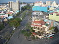
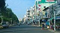
City scene

Cần Thơ market halls
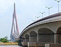
Cần Thơ bridge over the Sông Hậu

Can Tho International Airport
Hai Bà Trưng promenade


Web links
- Cần Thơ Community
- Cần Thơ University (English)
Individual evidence
- ↑ Statistical Yearbook of Vietnam 2014 - Area, population and population density by province. General Statistics Office Of Viet Nam, Hanoi, 2015, accessed February 10, 2016 (Vietnamese, English).
- ^ Sister Cities. phnompenh.gov.kh, archived from the original on December 12, 2010 ; accessed on February 16, 2013 .
- ^ Signature d'un jumelage avec la Ville-Province de Can Tho. nice-premium.com, September 25, 2011, accessed February 16, 2013 (French).
- ^ Partnership between Can Tho City, Vietnam and Riverside, California, USA. Consulate General of the SR Vietnam in San Francisco, September 25, 2011, accessed on September 9, 2017 (Vietnamese).
Regions: Northwest | Northeast | Red River Delta | Northern coastal region | Southern coastal region | Central highlands | Southeast | Mekong Delta
Large cities at the provincial level: Cần Thơ | Đà Nẵng | Hải Phòng | Hà Nội | Thành phố Hồ Chí Minh
Provinces: An Giang | Bắc Giang | Bắc Kạn | Bạc Liêu | Bắc Ninh | Bà Rịa-Vũng Tàu | Bến Tre | Bình Định | Bình Dương | Bình Phước | Bình Thuận | Cà Mau | Cao Bằng | Đắk Lắk | Đắk Nông | Điện Biên | Đồng Nai | Đồng Tháp | Gia Lai | Hà Giang | Hải Dương | Hà Nam | Hà Tĩnh | Hòa Bình | Hậu Giang | Hưng Yên | Khánh Hòa | Kiên Giang | Kon Tum | Lai Châu | Lâm Đồng | Lạng Sơn | Lào Cai | Long On | Nam Định | Nghệ An | Ninh Bình | Ninh Thuận | Phu Thọ | Phú Yên | Quảng Bình | Quảng Nam | Quảng Ngãi | Quảng Ninh | Quảng Trị | Sóc Trăng | Sơn La | Tây Ninh | Thái Bình | Thái Nguyên | Thanh Hóa | Thừa Thiên-Huế | Tiền Giang | Trà Vinh | Tuyên Quang | Vĩnh Long | Vĩnh Phúc | Yên Bái