
Oresund
| Oresund | |
|---|---|
 |
|
| Connects waters | Baltic Sea |
| with water | Kattegat |
| Separates land mass | Zealand |
| of land mass | Skåne ( Sweden ) |
| Data | |
| Geographical location | 55 ° 47 ' N , 12 ° 45' E |
 |
|
| length | 181 km |
| Smallest width | 4 km |
| Greatest depth | 40 m |
| Coastal towns | Copenhagen , Malmö , Helsingør , Helsingborg |
| Islands | Ven , Amager , Saltholm , Peberholm |
| bridges | Oresund Bridge |
| tunnel | Drug tunnel |
 |
|
The Øresund (Danish spelling: Øresund ; historical German name: Sund ) is the strait between Zealand ( Denmark ) and Scania ( Sweden ) that connects the Baltic Sea with the Kattegat .
history
About 9000 years ago the Scandinavian shield began to tip over - freed from the weight of the Ice Age ice. It rose in the north and fell in the south. The North Sea water penetrated the Baltic Sea area from the north, flooded the former mainland and created the Danish islands and Sunde in the following millennia .
The name Öresund (Øresund) has only been documented in Danish sources since 1343. In the times of the Vikings it was possibly called Einarsund (as in Ragnar Lodbrok's Song of the Dead ). In medieval sources it is usually called Noresund (northern or narrow sound - English: narrow ?). For a long time in Germany it was only called the Sound .
From 1429 to 1857 Denmark levied a sound tariff for the passage of ships . Until the Peace of Roskilde in 1658, the Skåne banks of the Øresund also belonged to Denmark.
There were plans for a permanent connection across the Øresund as early as the 19th century. Plans for a railway tunnel (the so-called HH tunnel between Helsingborg and Helsingør) are discussed again and again.
After the occupation of Denmark by the Wehrmacht of the German Reich in 1940, the Reichsautobahn company began planning the construction of motorways in Denmark. Among other things, they included two drafts of a bridge over the Öresund to connect Sweden. The variants were a truss girder bridge with spans of up to 300 meters and a suspension bridge with three main openings of 756 meters. In 1942 the planning was stopped.
In the 1960s, the founder of the packaging group Tetra-Pak , Ruben Rausing , even had the idea of draining the waterway and building it in the Ørestad area. The oil crisis prevented this bold plan for good.
The Øresund connection was established on July 1, 2000 by Queen Margrethe II of Denmark and King Carl XVI. Gustaf of Sweden officially opened. South of the Öresund Bridge, the Lillgrund offshore wind farm is also Sweden's largest offshore wind farm as of 2015 .
Islands
In the Öresund are the islands of Ven (to Sweden ) as well as Amager , Saltholm and the artificial island of Peberholm (all to Denmark ).
links
The two largest cities in the Öresund are Copenhagen and Malmö by the Öresund link together to Öresund region are linked. The shortest ferry connection across the Öresund is between the Danish Helsingør and the Swedish Helsingborg . There, north of Copenhagen and Malmö, is the narrowest point of the strait at around four kilometers.
In a four-year test period, the Danish-Swedish monitoring of shipping traffic showed that 200 events required active advice to prevent unsafe navigation and run-up. Since September 1, 2011, all ships over 300 GRT have to register with SOUNDREP if they want to cross the Sound, at Kullen in the north and at Trelleborg in the south.
Pictures and cards
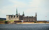
Kronborg Castle ,
the old Danish checkpoint
Oresund around 1888

Northern part of the Oresund

Oresund Bridge - view from Klagshamn


literature
- The sound . In: The Gazebo . Issue 35, 1853, pp. 376–379 ( full text [ Wikisource ]).
Web links
Individual evidence
- ↑ History of the Baltic Sea with board: State 8000 years before today
- ↑ Peter Frederik Suhm: En Historie af Danmark. Volume XIII, p. 77, cit. Kurd von Schlözer: The Hansa and the German order of knights in the Baltic countries . Reprint of the edition from 1851. VMA Wiesbaden n.J., p. 179, note 85
- ^ Website of Helsingborg City Planning ( Memento from October 27, 2014 in the Internet Archive )
- ↑ Tilman Harlander , Wolfram Pyta (Ed.): Nazi Architecture: Power and Symbol Politics (series of publications by the International Center for Research on Culture and Technology at the University of Stuttgart, Volume 19). 2012, ISBN 978-3-643-10944-6 , p. 205.
- ↑ Andreas Knudsen: SOUNDREP - Eye and Ear at the Öresund. Unique Danish-Swedish monitoring of shipping traffic. In: Marineforum. 12/2011, p. 32.