
Tây Nguyên
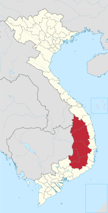
Tây Nguyên ( Vietnamese for "Western plateau", from Chinese 西 原 ; in German known as the Zentrales Hochland , English Central Highlands ) is an area in Vietnam . It borders Cambodia and Laos . To it belong the provinces Đắk Lắk , Đắk Nông , Gia Lai , Kon Tum and Lâm Đồng . A large part of the population of Tây Nguyên consists of ethnic minorities such as Mường , Thái and Hoa (Chinese).
The role of the center is shared by the cities of Buôn Ma Thuột as the largest and Đà Lạt as a tourist attraction (also and especially for Vietnamese tourists).
The highlands play an important role for Vietnamese foreign trade, especially as a coffee growing area. In addition, other fruits and vegetables that are rarely found in Southeast Asia thrive in the highlands, such as strawberries, wine, practically all types of cabbage and even unusual vegetables such as artichokes and asparagus.
Web links
Regions: Northwest | Northeast | Red River Delta | Northern coastal region | Southern coastal region | Central highlands | Southeast | Mekong Delta
Large cities at the provincial level: Cần Thơ | Đà Nẵng | Hải Phòng | Hà Nội | Thành phố Hồ Chí Minh
Provinces: An Giang | Bắc Giang | Bắc Kạn | Bạc Liêu | Bắc Ninh | Bà Rịa-Vũng Tàu | Bến Tre | Bình Định | Bình Dương | Bình Phước | Bình Thuận | Cà Mau | Cao Bằng | Đắk Lắk | Đắk Nông | Điện Biên | Đồng Nai | Đồng Tháp | Gia Lai | Hà Giang | Hải Dương | Hà Nam | Hà Tĩnh | Hòa Bình | Hậu Giang | Hưng Yên | Khánh Hòa | Kiên Giang | Kon Tum | Lai Châu | Lâm Đồng | Lạng Sơn | Lào Cai | Long On | Nam Định | Nghệ An | Ninh Bình | Ninh Thuận | Phu Thọ | Phú Yên | Quảng Bình | Quảng Nam | Quảng Ngãi | Quảng Ninh | Quảng Trị | Sóc Trăng | Sơn La | Tây Ninh | Thái Bình | Thái Nguyên | Thanh Hóa | Thừa Thiên-Huế | Tiền Giang | Trà Vinh | Tuyên Quang | Vĩnh Long | Vĩnh Phúc | Yên Bái
Coordinates: 13 ° 45 ' N , 108 ° 15' E