
Sa Pa

| Sa Pa | |||
|---|---|---|---|
|
|||
| Basic data | |||
| Country: |
|
||
| Region: | North Vietnam ( Bắc Bộ ) | ||
| Region : | Northwest ( Tây Bắc Bộ ) | ||
| Province : | Lào Cai (Province) | ||
| ISO 3166-2: VN : | VN-02 | ||
| Coordinates : | 22 ° 21 ′ N , 103 ° 52 ′ E | ||
| Height : | 1,600 m | ||
| Further information | |||
| Time zone : | UTC +7: 00 | ||

Sa Pa , (also: Sapa ) is the capital of the district of the same name in Vietnam's north-western border province of Lao Cai . It is an important market town in this area, with importance for the Hmong , Red Dao and Tay hill tribes living in the area . The region is home to around 38,000 residents.
geography
Sa Pa is located at an altitude of about 1,600 meters in the Hoàng Liên Sơn Mountains. The Hoang Lien National Park is established here. The Vietnamese capital Hanoi is 350 kilometers south-east, and the nearest train station, Lao Cai, is an hour's drive away. Vietnam's highest mountain, the Fansipan, is located near Sa Pa (less than 10 km away) . The climate is temperate, the summers (May to August) are rainy. In winter the weather is quite cool, often foggy with occasional snowfalls. The average temperature is 15 to 18 ° C.
history

Sa Pa was probably first inhabited by the hill tribes of the Hmong and Yao who still settle in the area today. Around 1880, the French colonial rulers founded a mountain station, also called Chapa , at this location . This was expanded into a village in 1922 and used by the French as a resort. A Đà Lạt of the north was even planned , but the French failed because of the inadequate transport links.
Municipalities of Sa Pas
The individual municipalities assigned to Sa Pa are: Ban Khoang, Ta Giang Phinh, Trung Chai, Ta Phin, Sa Pa, San Sa Ho, Ban Phung, Lao Chai, Hau Thao, Thanh Kim, Ta Van, Su Pan, Suoi Thau, Ban Ho, Thanh Phu, Nam Sai, Nam Cang.
gallery

Rice cultivation near Sa Pa

Sa Pa market

Rice terraces near Sa Pa

Sa Pa and Sa Pa Lake from Ham Rong Mountain
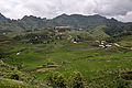
Extensive rice cultivation near Sa Pa


