
Administrative division of the People's Republic of China

The People's Republic of China is administratively and politically divided into six main levels:
- The national level in the understanding of the People's Republic refers to the whole of China, i.e. includes Taiwan .
- The provincial level comprises the most important administrative divisions, which are also best known outside of China. China has been divided into provinces for many centuries.
- The district level has since the beginning of reform and opening become increasingly important, and especially independence 1981st
- The county level heard the provincial level, the oldest administrative organization of China.
- The municipal level has been subjected to a comprehensive administrative reform since the 1980s, some of which is still ongoing today. As at the district level, it should meet the demands on local decision-making authority that have grown in the context of economic reforms.
- The village level is the level of the direct contact zone between the state and citizens and is therefore of great importance for the implementation of domestic political guidelines.
While the top two and the bottom two of these six levels are represented in every place in China, the district level is missing in some places and the district level in others. For example, in the cities directly under the government, in the autonomous region of Xinjiang, in the province of Hainan and in other provinces, the county level is subordinate directly to the provincial level. In contrast, in some prefecture-level cities (Sansha, Zhongshan, Jiayuguan) the county level, i.e. H. the municipal level is directly subordinate to the district level. Since autumn 2011 there has been one case ( Xialu in Huangshi ) in which the county level dissolved the community level and the village level subordinated itself directly. In July 2014, the four urban districts of Sanyas were added, and the community level was also dissolved when they were re-established. Whether these are individual cases or whether there is a trend towards restructuring the administration at least in the city districts cannot yet be said.
The terms district, district and municipality are not to be equated with those terms used in the administrative structure of the Federal Republic of Germany . So is z. B. the Chinese level of the municipalities of the size and not competence according to the German district (area) comparable, as well as the Chinese district to the German administrative district .
Provincial level
Administrative divisions at provincial level are:
- the 23 provinces (from the perspective of the People's Republic including Taiwan). Most of the provinces have existed within their borders since the Ming Dynasty .
- the four cities directly under the government .
- the two special administrative areas . These have been provided for in the constitution since 1982 , but were only set up under the principle of one country, two systems for the return of Hong Kong and Macau .
- the five autonomous regions . These existed as a province before the establishment of the PRC and were set up for national minorities in their traditional settlement areas.

List of provinces
The provinces are arranged alphabetically. Under the references of this article there are links to other collations. The area details are shown in square kilometers. The population figures are the results of the 2010 census.
| Surname | Abbreviation | Long characters | Pinyin | abbreviation | Capital | Area km² | population |
|---|---|---|---|---|---|---|---|
| Anhui | 安徽 | 安徽 | Ānhuī | 皖 wǎn | Hefei | 139.057 | 59,500,510 |
| Fujian | 福建 | 福建 | Fújiàn | 闽 mǐn | Fuzhou | 123.603 | 36,894,216 |
| Gansu | 甘肃 | 甘肅 | Gansu | 甘 gān, 陇 lǒng | Lanzhou | 464.186 | 25,575,254 |
| Guangdong | 广东 | 廣東 | Guǎngdōng | 粤 yuè | Guangzhou | 177.933 | 104.303.132 |
| Guizhou | 贵州 | 貴州 | Guìzhōu | 黔 qián, 贵 guì | Guiyang | 176.505 | 34,746,468 |
| Hainan | 海南 | 海南 | Hǎinán | 琼 qióng | Haikou | 34,353 | 8,671,518 |
| Hebei | 河北 | 河北 | Héběi | 冀 jì | Shijiazhuang | 187.991 | 71.854.202 |
| Heilongjiang | 黑龙江 | 黑龍江 | Hēilóngjiāng | 黑 hēi | Harbin | 432,477 | 38.312.224 |
| Henan | 河南 | 河南 | Henan | 豫 yù | Zhengzhou | 166,499 | 94.023.567 |
| Hubei | 湖北 | 湖北 | Húběi | 鄂 è | Wuhan | 185.125 | 57.237.740 |
| Hunan | 湖南 | 湖南 | Hú'nán | 湘 xiāng | Changsha | 211,836 | 65,683,722 |
| Jiangsu | 江苏 | 江蘇 | Jiāngsū | 苏 sū | Nanjing | 97,607 | 78.659.903 |
| Jiangxi | 江西 | 江西 | Jiāngxī | 赣 gàn | Nanchang | 167,430 | 44,567,475 |
| Jilin | 吉林 | 吉林 | Jílín | 吉 jí | Changchun | 192.105 | 27,462,297 |
| Liaoning | 辽宁 | 遼寧 | Liáoníng | 辽 liáo | Shenyang | 147.785 | 43,746,323 |
| Qinghai | 青海 | 青海 | Qīnghǎi | 青 qīng | Xining | 716.693 | 5,626,722 |
| Shaanxi | 陕西 | 陝西 | Shǎnxī | 陕 shǎn, 秦 qín | Xi'an | 205,693 | 37,327,378 |
| Shandong | 山东 | 山東 | Shāndōng | 鲁 lǔ | Jinan | 156,867 | 95.793.065 |
| Shanxi | 山西 | 山西 | Shānxī | 晋 jìn | Taiyuan | 157.023 | 35.712.111 |
| Sichuan | 四川 | 四川 | Sìchuān | 川 chuān, 蜀 shǔ | Cheng you | 491.146 | 80.418.200 |
| Yunnan | 云南 | 雲南 | Yúnnán | 滇 diān, 云 yún | Kunming | 393.734 | 45.966.239 |
| Zhejiang | 浙江 | 浙江 | Zhèjiāng | 浙 zhè | Hangzhou | 103,900 | 54,426,891 |
Controversial Status of Taiwan
Since its founding in 1949, the People's Republic of China has regarded Taiwan as its 23rd province .
However, the Republic of China controls Taiwan Province , Jinmen County, and a municipality in Lianjiang County, Fujian Province . The Republic of China also claimed the entire territory of the People's Republic of China, including Tibet , Outer Mongolia (today's State of Mongolia ), Urjanchai (today's Republic of Tuva (Russia)) and other areas beyond today's borders of China. This claim was abandoned in 1991 by President Lee Teng-hui ; however, this has not been ratified by the National Assembly of the Republic of China.
In 1999, the outgoing president coined the two-China theory , which was followed up by the successor government. President Chen Shui-bian also stuck to this line, which he manifested through the policy of five no's . The last president of the Republic of China, Ma Ying-jeou , on the other hand, rejected Taiwan independence and pursued a policy of rapprochement with the People's Republic without questioning Taiwan's independence. Maps printed in Taiwan often depict the provincial borders as they were drawn in 1949, thereby ignoring the changes made to some provincial borders by the People's Republic of China since 1949.
List of autonomous regions
| Surname | Abbreviation | Long characters | Pinyin | abbreviation | Capital | Area km² | population |
|---|---|---|---|---|---|---|---|
| Guangxi | 广西 | 廣西 | Guǎngxī | 桂 guì | Nanning | 241.410 | 46,026,629 |
| Inner Mongolia | 内蒙古 | 内蒙古 | Nèi Měnggǔ | 蒙 měng | Hohhot | 1,218,698 | 24,706,321 |
| Ningxia | 宁夏 | 寧夏 | Níngxià | 宁 níng | Yinchuan | 55,461 | 6,301,350 |
| Xinjiang | 新疆 | 新疆 | Xīnjiāng | 新 xīn | Urumqi | 1,774,034 | 21,813,334 |
| Tibet | 西藏 | 西藏 | Xīzàng | 藏 zàng | Lhasa | 1,268,947 | 3,002,166 |
List of government immediate cities
| Surname | Abbreviation | Long characters | Pinyin | abbreviation | Area km² | population |
|---|---|---|---|---|---|---|
| Beijing | 北京 | 北京 | Běijīng | 京 jīng | 16.808 | 19,612,368 |
| Chongqing | 重庆 | 重慶 | Chóngqìng | 渝 yú | 82,403 | 28,846,170 |
| Shanghai | 上海 | 上海 | Shànghǎi | 沪 hù | 6,341 | 23,019,148 |
| Tianjin | 天津 | 天津 | Tiānjīn | 津 jīn | 11,632 | 12,938,224 |
The term “direct government” means that these cities - like provinces - are directly subordinate to the central government of China.
List of Special Administrative Areas
| Surname | Abbreviation | Long characters | Pinyin | abbreviation | Area km² | population |
|---|---|---|---|---|---|---|
| Hong Kong | 香港 | 香港 | Xiānggǎng | 港 gǎng | 1.104 | 6,961,931 |
| Macau | 澳门 | 澳門 | Àomén | 澳 ào | 24 | 517,000 |
Hierarchy of administrative units based on data from the People's Republic of China
As of December 31, 2013, no data from Hong Kong, Macau and Taiwan are included below the provincial level. The following data already take into account the district-free city of Sansha, which was founded on July 24, 2012 .
Provincial level
34 administrative units:
- 23 provinces ( 省 , shěng , with Taiwan );
- five autonomous regions ( 自治區 / 自治区 , zìzhìqū );
- four cities directly under the government ( 直轄市 / 直辖市 , zhíxiáshì );
- two special administrative regions ( 特別 行政區 / 特别 行政区 , tèbié xíngzhèngqū ).
District level
333 administrative units, of which
- 286 cities at the district level ( 地 級 市 / 地 级 市 , dìjíshì ), of which 15 are sub-provincial towns ( 副 省級 城市 / 副 省级 城市 , fù shěngjí chéngshì ). The administrative area of the cities at district level includes both the urban area and the surrounding greater region. For this reason, in addition to city districts, districts and urban districts are also subordinate to them.
- 30 Autonomous Districts ( 自治州 , zìzhìzhōu ).
- 14 administrative districts ( 地區 / 地区 , dìqū ).
- Three frets (aimag) , also called “leagues” ( Mongolian ᠠᠶᠢᠮᠠᠭ ayimaɣ [ æːmɑ̆ɡ̊ ], Cyrillic аймаг , 盟 , méng ); Bunds only exist in the Inner Mongolia Autonomous Region .
District level
2,853 (+7) administrative units
- 1,442 circles ( 縣 / 县 , xiàn ).
- 872 city districts ( 市 轄區 / 市 辖区 , shìxiáqū ).
- 368 independent cities ( 縣級 市 / 县级 市 , xiànjíshì ).
- 117 autonomous circles ( 自治縣 / 自治县 , zìzhìxiàn ).
- 49 banners ( Mongolian ᠬᠣᠰᠢᠭᠤ qosiγu , 旗 , qí ); Inner Mongolia Autonomous Region only .
- (Four subdistricts ( 區 / 区 , qū ); special case of the Great Hinggan Mountains administrative district in Heilongjiang Province ).
- Three autonomous banners ( 自治旗 , zìzhìqí ); Inner Mongolia Autonomous Region only.
- (Three administrative committees ( 行政 委員會 / 行政 委员会 , xíngzhèng wěiyuán huì ); special case in the Haixi Autonomous District of the Mongols and Tibetans in the Qinghai Province ).
- A special area ( 特區 / 特区 , tèqū ); only in Guizhou Province .
- A forest area ( 林區 / 林区 , línqū ); only in Hubei Province .
Community level
40,497 (+3) administrative units
- 20,117 localities ( 鎭 / 镇 , zhèn ).
- 11,626 parishes ( 鄕 / 乡 , xiāng ).
- 7,566 street quarters ( 街道 , jiēdào ).
- 1,034 nationality communities ( 民族鄉 / 民族乡 , mínzúxiāng ).
- 151 Sum ( Mongolian ᠰᠤᠮᠤ Cyrillic Сум , 蘇木 / 苏木 , sūmù ); Inner Mongolia Autonomous Region only .
- (Three hypothetical large communities 虛擬 鎭 / 虚拟 镇 , xūnǐzhèn special case, only in the province of Hainan ).
- Two administrative areas ( 區公所 / 区公所 , qūgōngsuǒ ).
- A nationality sum ( 民族 蘇木 / 民族 苏木 , mínzú sūmù ); Inner Mongolia Autonomous Region only .
Village level
The administrative units at the municipal level are composed of communities of residents ( 社區 / 社区 , shèqū ) in urban areas and villages ( 村 , cūn ) in rural areas . There are also in parts of Inner Mongolia, especially in the imprinted from the pasture livestock grassland that Gaqaa ( 嘎查 , Gacha ), "villages" of pastoralists.
In terms of political representation and power, the village level is of no great importance, but organizationally of great importance. The implementation of the policy decided at higher levels, the distribution of mail, the censuses (every ten years) would not be possible without the well-organized village level, which has clearly defined boundaries (such as the higher administrative units) and a responsible head in each case. Political representation of the resident communities are the "resident committees", often referred to as "neighborhood committees" ( 居民委員會 / 居民委员会 , jūmín wěiyuánhùi ), those of the villages the "village committees" ( 村民 委員會 / 村民委员会 , cūnmín wěiyuánhùi ).
It is currently not possible to give an exact number of administrative units at village level, as this is constantly changing due to the ongoing administrative reform in China.
Historical development of the provincial division since 1949
Since 1949, several provincial borders were readjusted. This mainly affected provinces in the outer peripheral areas (Manchuria, Inner Mongolia and neighboring areas). The core provinces of “ China proper ” remained largely unchanged from 1952 onwards.
 1949
1949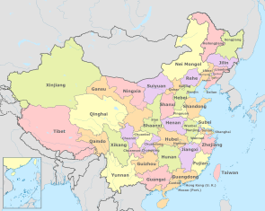 1950
1950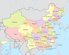 1952
1952 1954
1954 1955
1955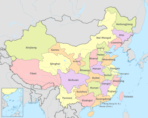 1956
1956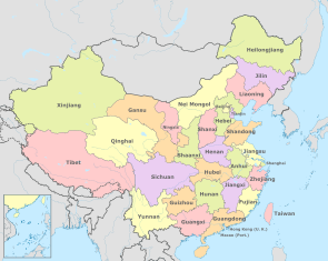 1968
1968 1979
1979


Former disbanded provinces
| location | province | Character ( pinyin ) | Abbr. | current affiliation |
|---|---|---|---|---|

|
Andong |
安 東 / 安 东 Āndōng |
- | today part of Liaoning and Jilin |

|
Chahar |
察哈爾 / 察哈尔 Cháhāěr |
察 / 察 Chá |
now part of Inner Mongolia |

|
Fengtian (before Shengjing) |
奉天 / 奉天 Fèngtiān (before that 盛京 / 盛京 Shengjing) |
奉 / 奉 Fèng |
today part of Liaoning
|

|
Hejiang |
合 江 / 合 江 Héjiāng |
- | today part of Heilongjiang |

|
Liaobei |
遼 北 / 辽 北 Liáoběi |
- | now part of Inner Mongolia |

|
deer |
熱河 / 热河 Rèhé |
熱 / 热 Rè |
today largely part of Hebei |

|
Songjiang |
松江 / 松江 Sōngjiāng |
- | today part of Heilongjiang |

|
Suiyuan |
綏遠 / 绥远 Suīyuǎn |
綏 / 绥 Suī |
now part of Inner Mongolia |

|
Xikang |
西康 / 西康 Xīkāng |
康 / 康 Kāng |
Today the western half belongs to Tibet , the eastern half to Sichuan . |

|
Xing'an |
興安 / 兴安 Xīng'ān |
- | now part of Inner Mongolia |
See also
- Autonomous Administrative Units of China
- List of administrative units of the People's Republic of China by area
- List of administrative units of the People's Republic of China by population
- List of the administrative units of the People's Republic of China by population density
- List of the administrative units of the People's Republic of China according to economic output
- List of the administrative divisions of the People's Republic of China according to the Human Development Index
- List of cities in the People's Republic of China
literature
- Yan Junxu (Red.): Geography (= China book series. ). Foreign Language Literature Publishing House, Beijing 1984.
- Qi Wen (齐 雯): China in outline. Foreign Language Literature Publishing House, Beijing 1985.
- Qin Shi (秦 石): China. Neuer Stern-Verlag, Beijing 1994, ISBN 7-80102-126-6 (2nd edition, ibid 1997, ISBN 7-80102-731-0 ).
- Xinwen Zhou: China. Facts and figures 1999. Neuer Stern-Verlag, Beijing 1999, ISBN 7-80148-193-3 .
- Ren Shuyin (任 树 银): China. Regional studies. Foreign Language Literature Publishing House, Beijing 2001, ISBN 7-119-02850-2 .
- Zhong Xin (钟欣) (Ed.): China 2002. Neuer Stern publishing house, Beijing 2002, ISBN 7-80148-479-7 .
- Erling von Mende , Heike Holbig: Local administration. In: Stefan Friedrich, Hans-Wilm Schütte, Brunhild Staiger (eds.) The great China Lexicon. History, geography, society, politics, economy, education, science, culture. Wissenschaftliche Buchgesellschaft, Darmstadt 2003, ISBN 3-534-14988-2 , pp. 456–458.
- Sebastian Heilmann : Political System, 3rd People's Republic. In: Stefan Friedrich, Hans-Wilm Schütte, Brunhild Staiger (eds.) The great China Lexicon. History, geography, society, politics, economy, education, science, culture. Wissenschaftliche Buchgesellschaft, Darmstadt 2003, ISBN 3-534-14988-2 , pp. 575-578.
- Yin Zhongqing (尹中卿): The political system in China today. China Intercontinental Press, Beijing 2004, ISBN 7-5085-0470-4 .
- Meyer's Atlas China. On the way to world power. Bibliographisches Institut AG, Mannheim 2010, ISBN 978-3-411-08281-0 , pp. 92-93.
Web links
- Current Chinese page on the administrative structure of the People's Republic of China (Chinese)
- Statistical Yearbooks of the People's Republic of China from 1999 (Chinese)
Afghanistan | Egypt | Armenia | Azerbaijan | Bahrain | Bangladesh | Bhutan | Brunei | China | Georgia | India | Indonesia | Iraq | Iran | Israel | Japan | Yemen | Jordan | Cambodia | Kazakhstan | Qatar | Kyrgyzstan | Korea, North Korea | Korea, South Korea | Kuwait | Laos | Lebanon | Malaysia | Maldives | Mongolia | Myanmar | Nepal | Oman | East Timor | Pakistan | Philippines | Russia | Saudi Arabia | Singapore | Sri Lanka | Syria | Tajikistan | Thailand | Turkmenistan | Turkey | Uzbekistan | United Arab Emirates | Vietnam | Cyprus
Administrative division of the States of:
Africa |
Asia |
Australia and Oceania |
Europe |
North and South America