
Lhasa
 |
|
| Country | People's Republic of China |
| Management type | District-free city |
| Time zone | China Standard Time (CST) UTC +8 (no daylight saving time ) |
| height | 3650 m |
| surface | 31,662 km² |
| population | 474,499 (2000) |
| Population density | 14.99 inhabitants / km² |
| Post Code | 891 |
| Structure at district level: | 1 city district, 7 districts |
| Structure at community level: | 6 street quarters, 4 municipalities |
| prefix | (+86) 891 |
| Official website | www.lasa.gov.cn |
| politics | |
|---|---|
| Mayor : | Doje Cezhug |
| Coordinates: 29 ° 39 ' N , 91 ° 8' E | |

Lhasa ( Tibetan ལྷ་ ས་ Wylie lha sa , also Lasa ; Chinese 拉薩 / 拉萨 , Pinyin Lāsà ) is the capital of the Tibet Autonomous Region of the People's Republic of China .
It is located in a high mountain valley and was founded near a temple. It is still of great religious importance today and is home to many monks. An important sight is the Potala Palace , the former palace of the Dalai Lama .
Lhasa has been connected to the Chinese rail network since 2006. The city, which is mainly inhabited by Tibetans, has a Han population of around one third in the inner city district .
geography
Lhasa is located in the Transhimalaya Mountains. It is located about 3600 m above sea level in the valley of the Lhasa He (Tib .: lha sa gtsang po), a tributary of the Yarlung Zangbo . The city lies on its northern bank and extends today in a west-east direction for more than 10 kilometers.
Administrative and ethnic division of Lhasa
After 1950 the population and the area of Lhasa grew by leaps and bounds. While only 20,000 to 25,000 people lived in the city around 1950, and this on an area of only 3 km² in front of the Potala Palace, and in addition 15,000 to 20,000 monks in the surrounding monasteries, in 2000 there were almost 475,000 people now almost a million. Almost half of Lhasa’s population lives in the Chengguan ( Thrinkönchü ) district. This district includes the urban area of Lhasa (i.e. the city proper).
Administrative division of Lhasa
The administrative area of the city of Lhasa, consisting of the district of Chengguan ( Thrinkönchü , "inner city"), two further districts and five districts, has a total area of 31,662 km² and according to the census (2000) 474,499 inhabitants (population density: 14.99 inhabitants / km²) .

2. Doilungdêqên
- City district Chengguan (Tib: ཁྲིན་ ཀོན་ ཆུས, khrin kon chus, Thrinkönchü, "inner city", Chinese 城关 区 Chéngguān Qū)
- Municipality of Doilungdêqên (Tib .: སྟོད་ ལུང་ བདེ་ ཆེན་ ཆུས, stod lung bde chen chus, 堆 龙 德庆 区 Duīlóngdéqìng Qū), main town: Donggar municipality (东 嘎 镇),
- District of Dagzê (Tib .: སྟག་ རྩེ་ ཆུས, stag rtse chus, 达孜 区 Dázī Qū), capital: Greater municipality of Dêqên (德庆 镇),
- the district Lhünzhub (Tib .: ལྷུན་ གྲུབ་ རྫོང, lhun grub rdzong, Lhündrub Dzong, 林 周 县 Línzhōu Xiàn), main town: Ganqoin ((曲 镇),
- Damxung district (Tib .: འདམ་ གཞུང་ རྫོང, ´dam gzhung rdzon, Damshung Dzong, 当雄县 Dāngxióng Xiàn), main town: Gungthang municipality (公 塘乡),
- Nyêmo district (tib .: འདམ་ གཞུང་ རྫོང, sne mo rdzong, Nyemo Dzong, 尼 木 县 Nímù Xiàn), main town: Tarrong municipality (塔 荣 镇),
- the district of Qüxü (Tib .: ཆུ་ ཤུར་ རྫོང, chu shur rdzong, Chushur Dzong, 曲水县 Qūshuǐ Xiàn), main town: large community Qüxü (曲 水镇),
- the Maizhokunggar district (Tib .: མལ་ གྲོ་ གུང་ དཀར་ རྫོང, sometimes gro gung dkar rdzong, Meldro Gungkar Dzong, 墨竹 工 卡 县 Mòzhúgōngkǎ Xiàn), main town: Gungkar municipality (工 卡 镇).
Ethnic breakdown of the population

The total population of Lhasa (city) in 2000 was 521,500. According to the November 2000 census, the ethnic distribution in the urban area of Lhasa is as follows (army personnel are excluded from this census):
| Ethnic groups in Lhasa at the level of prefecture-level city | |||||||
|---|---|---|---|---|---|---|---|
| Total | Tibetans | Han | other | ||||
| Lhasa as a whole | 474,499 | 387.124 | 81.6% | 80,584 | 17.0% | 6,791 | 1.4% |
| Chengguan District | 223.001 | 140.387 | 63.0% | 76,581 | 34.3% | 6,033 | 2.7% |
| Lhünzhub district | 50,895 | 50,335 | 98.9% | 419 | 0.8% | 141 | 0.3% |
| Damxung County | 39,169 | 38,689 | 98.8% | 347 | 0.9% | 133 | 0.3% |
| Nyêmo county | 27,375 | 27,138 | 99.1% | 191 | 0.7% | 46 | 0.2% |
| District Qüxü | 29,690 | 28,891 | 97.3% | 746 | 2.5% | 53 | 0.2% |
| Doilungdêqên district | 40,543 | 38,455 | 94.8% | 1,868 | 4.6% | 220 | 0.5% |
| Dagzê district | 24,906 | 24,662 | 99.0% | 212 | 0.9% | 32 | 0.1% |
| Maizhokunggar County | 38,920 | 38,567 | 99.1% | 220 | 0.6% | 133 | 0.3% |
Ethnic groups throughout the city:
| Name of the people | Residents | proportion of |
|---|---|---|
| Tibetans | 387.124 | 81.59% |
| Han | 80,584 | 16.98% |
| Hui | 4,741 | 1.00% |
| Bai | 271 | 0.06% |
| Do | 252 | 0.05% |
| Mongols | 200 | 0.04% |
| Tujia | 184 | 0.04% |
| Bouyei | 173 | 0.04% |
| Others | 970 | 0.20% |
The district of Chengguan ("inner city" 城关 区) has an area of 523 km² and according to the census from 2000 223,001 inhabitants; this means a population density of 426.39 inhabitants / km². Ethnic groups in detail:
| Name of the people | Residents | proportion of |
|---|---|---|
| Tibetans | 140.387 | 62.95% |
| Han | 76,581 | 34.34% |
| Hui | 4,429 | 1.99% |
| Do | 249 | 0.11% |
| Bai | 248 | 0.11% |
| Tujia | 179 | 0.08% |
| Mongols | 145 | 0.07% |
| Miao | 101 | 0.05% |
| Others | 682 | 0.31% |
history

The history of Lhasa goes back to the 7th century. At that time, the Jokhang Temple, still today the religious center of the old town of Lhasa, the Ramoche Temple and the first palace of the Tibetan King Songtsen Gampo (r. 620–649) on the red hill (tib .: dmar-po ri) founded. This stood where the Potala Palace is today. Two chapels located in the Potala. a. dedicated to the Greater Tibetan line of kings are considered remnants of this palace. In the 15th century, the Gelug Buddhist school built three monasteries in the vicinity of Lhasa: Sera , Drepung and Ganden . In the 17th century, the Potala Palace was rebuilt on the "Red Hill" under Ngawang Lobsang Gyatsho , the fifth Dalai Lama , and the Jokhang Temple was also enlarged.
In the first half of the 20th century, various Western personalities made trips to the city, including Francis Younghusband , Alexandra David-Néel , Heinrich Harrer and Peter Aufschnaiter .
Word history of the name
Today the meaning of the name Lhasa is usually given as Tibetan “place of gods”. In the time of the Yarlung Dynasty , this place was named (Tib. :) rva-sa, which meant a fenced pasture. The interpretation “goat pasture” is also possible. This is also reminiscent of the name of this place in today's Lhasa dialect. Here the name is pronounced with API ɬ ̄ɛ: s ̄a, which corresponds to the written Tibetan “lhas sa”. This in turn means “fenced place” (rva sa). Ultimately, it should also be noted that tib .: lha was also the name for the Tibetan kings regarded as divine, so that Lhasa was initially understood as the “place of kings” and was later reinterpreted as “place of gods”.
traffic
Roads lead to the provinces of Sichuan ( Chengdu ), Qinghai ( Xining ) and the neighboring country of Nepal . Lhasa is on the G318 national road , which runs from Shanghai via Wuhan , Chengdu, Garzê , Litang , Batang , Markam , Bayi to Lhasa and from there via Samzhubzê and Lhazê to Kathmandu in Nepal or from Lhazê as G219 via western Tibet to Kargilik at Yarkant in Xinjiang . Lhasa is also at the end of the G109 national road , which runs from Beijing via Datong , Dongsheng , Lanzhou , Qinghai Lake and Golmud to Lhasa.
Since the completion of the Lhasa Railway on July 1, 2006 , with an apex of 5,072 m, the highest railway line in the world and the highest station at 5,068 meters, Lhasa has been connected to the Chinese railway network. This cuts the travel time from Lhasa to Beijing to around fifty hours. The Lhasa Railway Station is located in the development area on the south bank of the Lhasa River. On August 15, 2014, a 253-kilometer extension to Xigazê was put into operation.
The airport of Lhasa is located 45 km to the south in the district Gongkar .
Culture and sights
_Dieter_Schuh.JPG)
_2007_Dieter_Schuh.JPG)
According to the tradition of Tibetan Buddhism, there are three concentric pilgrimage routes in Lhasa . The innermost route, Nangkhor , includes a walking tour in the courtyard of Jokhang Temple. The middle route is called Barkhor and includes a walk around the Jokhang Temple and other monasteries and temples in the old town. The outermost route, called Lingkhor , follows the earlier city limits. This part of the old town is now also open to tourists.
The main attraction in Lhasa is the Potala Palace , the former palace of the Dalai Lama .
The Tibet Museum , which opened in 1999, shows more than 30,000 exhibits from Tibetan culture (see Buddhist art ).
Tibet University, founded in 1985, is located in Lhasa.
gallery

Lhasa

Roof of the Potala Palace
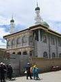
A mosque in Lhasa

The Jokhang Temple in Lhasa

Inner courtyard of the Potala Palace


Climate table
|
Average monthly temperatures and rainfall for Lhasa
Source: wetterkontor.de
|
|||||||||||||||||||||||||||||||||||||||||||||||||||||||||||||||||||||||||||||||||||||||||||||||||||||||||||||||||||||||||||||||||||||||||||||||||||||||||||||||||||||
The climate of Lhasa is characterized above all by enormous temperature fluctuations between day and night.
literature
- Andre Alexander: The Temples of Lhasa. Tibetan Buddhist Architecture from the 7th to the 21st Century. Serindia, Chicago 2005.
- F. Spencer Chapman: Lhasa the Holy City . R. & R. Clark, London 1940, reprint ISBN 0-8369-6712-7 ; Chinese translation (2004) ISBN 7-80057-460-1 .
- Knut Larsen and Amund Sinding-Larsen: The Lhasa Atlas. Traditional Tibetan Architecture and Townscape. Shambala, Boston 2001.
- Roberto Vitali: Early Temples of Central Tibet. Serindia, London 1990.
- Ulrich von Schroeder: Buddhist Sculptures in Tibet. Vol. One: India & Nepal ; Vol. Two: Tibet & China . Visual Dharma Publications, Hong Kong 2001.
- Ulrich von Schroeder: 108 Buddhist statues in Tibet. Serindia & Visual Dharma Publications, Chicago 2008.
Web links
- Official Website (Chinese)
Individual evidence
- ↑ Department of Population, Social, Science and Technology Statistics of the National Bureau of Statistics of China (国家 统计局 人口 和 社会 科技 统计 司) and Department of Economic Development of the State Ethnic Affairs Commission of China (国家 民族 事务 委员会 经济 发展司), eds. Tabulation on Nationalities of 2000 Population Census of China ("2000 年 人口普查 中国 民族 人口 资料"). 2 vols. Beijing: Nationalities Publishing House (民族 出版社), 2003. ( ISBN 7-105-05425-5 ).
- ↑ derstandard.at
- ^ Gary McCue: Trekking Tibet: A Traveler's Guide. 3rd edition, Verlag The Mountaineers Books, 2010, ISBN 978-1-59485-411-8 , chapter The Lingkor , p. 68 f ( limited preview in Google book search).