Litang
«»
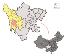
Litang ( Tibetan ལི་ ཐང ་. Wylie li thang ; and Lithang , Chinese 理塘县 , pinyin Lǐtáng Xiàn ) is a circle of the administrative territory of the Autonomous District Garzê of Tibetans in the northwestern Chinese province of Sichuan belongs. It has an area of 13,677 square kilometers and has a population of around 50,000 (2004). Its main town is the large community of Gaocheng (Gāochéng 高 城镇 ).
Administrative structure
At the community level, the district consists of one large community and twenty-three communities . These are (pinyin / chin.):
- Greater community Gaocheng高城镇
- Junba municipality 君 坝乡
- Heyi municipality 哈 依 乡
- Community Juewu觉吾乡
- Moba municipality 莫 坝乡
- Community Yahuo亚火乡
- Community Rongba绒坝乡
- Community Xiake呷柯乡
- Benge municipality 奔 戈 乡
- Community Cunge村戈乡
- Community Heni禾尼乡
- Community Qudeng曲登乡
- Community Lamaya喇嘛垭乡
- Community Zhangna章纳乡
- Community Shangmula上木拉乡
- Community Xiamula下木拉乡
- Community Zhongmula中木拉乡
- Community Zhuosang濯桑乡
- Community Jiawa甲洼乡
- Community Cangba藏坝乡
- Gemu municipality 格 木 乡
- Community Labo拉波乡
- Maiwa parish 麦 洼 乡
- Dewu parish 德 巫 乡
Ethnic breakdown of the population (2000)
At the 2000 census, Litang had 49,453 inhabitants.
| Name of the people | Residents | proportion of |
|---|---|---|
| Tibetans | 46.405 | 93.84% |
| Han | 2,832 | 5.73% |
| Hui | 98 | 0.2% |
| Bai | 32 | 0.06% |
| Yi | 28 | 0.06% |
| Mongols | 11 | 0.02% |
| Uighurs | 10 | 0.02% |
| Tujia | 9 | 0.02% |
| Miao | 6th | 0.01% |
| Salar | 4th | 0.01% |
| Naxi | 4th | 0.01% |
| Others | 14th | 0.03% |
See also
Web links
Commons : Litang - collection of images, videos and audio files
- Info page (chinese)
Coordinates: 29 ° 52 ' N , 100 ° 7' E


