Samzhubzê
| Tibetan name |
|---|
|
Tibetan script :
བསམ་ འགྲུབ་ རྩེ་ ཆུས །
|
|
Wylie transliteration : bsam 'grub rtse
|
|
Official transcription of the PRCh : Samzhubzê
|
|
THDL transcription : -
|
|
Other spellings: Samdruptse
|
| Chinese name |
|
Traditional :
桑 珠 孜 區
|
|
Simplified :
桑 珠 孜 区
|
|
Pinyin : Sāngzhūzī Qū
|
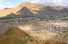
Samzhubzê ( Tibetan : བསམ་ འགྲུབ་ རྩེ་ ཆུས ། , inscription after Wylie : bsam 'grub rtse ) has been a district of the independent city of Xigazê since June 26, 2014 and also its seat of government. Samzhubzê emerged from the former independent city of Xigazê.
The administrative area Samzhubzês has an area of 3,654.18 km² and 120,374 inhabitants (2010 census). In the 2000 census, 99,863 residents were counted. The municipality is located on the Nyang Qu just before its confluence with the Yarlung Zangbo (Brahmaputra), at 3,840 m above sea level. The annual average temperature is 6 ° C and the annual rainfall averages 420 mm.
Administrative structure
At the municipality level, the municipality consists of two street districts and ten municipalities . These are (population figures: 2000 census):
- Chengbei street district (城北 街道 = "north city"), 10,694 inhabitants
- Street district Chengnan (城南 街道 = "South City"), 35,366 inhabitants
- Qumig municipality (曲 美 乡), 5,692 inhabitants
- Nyarixung municipality (聂 日 雄 乡), 4,757 inhabitants
- Qugboxung municipality (曲 布 雄 乡), 5,160 inhabitants
- Lhain municipality (联 乡), 4,768 inhabitants
- Community Gyacoxung (甲措雄乡), 11,454 inhabitants
- Community Nar (纳尔乡), 1,765 inhabitants
- Nyamo municipality (年 木 乡), 2,926 inhabitants
- Donggar Municipality (东 嘎 乡), 8,748 inhabitants
- Benxung municipality (边 雄 乡), 3,897 inhabitants
- Jangdam municipality (江 当 乡), 4,636 inhabitants
history
The current city district developed at the foot of the old fortress Samzhubzê (Tib .: bsam grub rtse ), which was built in 1363 and after which it is named. Until the 20th century, the place was often simply called " Shigatse Dzong ".
Until the middle of the 17th century, Samzhubzê was the seat of the kings of Tsang , who ruled large parts of Tibet - including Lhasa - from here for a long time. When at the beginning of the 17th century the Gelugpa were able to gain supremacy with the help of the Mongols from Amdo , the 5th Dalai Lama became "ruler of Tibet" in 1642. However, since he resided in Lhasa, the Potala Palace was built there, whose model is likely to have been the Samzhubzê or Shigatse Dzong Castle. In magnificence and dimension, however, it clearly towered above this. In 1950 the Samzhubzê fortress was destroyed. In the period from 2005 to 2007, it was reconstructed with donations from Shanghai. Old photos served as the basis for the reconstruction, but today the construction is carried out in cement or concrete walls, which are then to be clad with natural stone on the outside. It is to be transformed into a museum about the ancient culture of the city.
Trashilhünpo
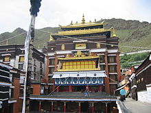
In Samzhubzê is the seat of the Penchen Lama , one of the most important authorities in Tibetan Buddhism. The Penchen Lama has resided in Trashilhünpo Monastery , the most important monastery of the Gelug tradition in western Tibet, since 1446 .
In 1791 the town and monastery were attacked and looted by the Gurkhas who invaded Nepal . This invasion from the southern neighboring kingdom prompted the Lhasa government to ask the Manchu-Chinese ruler in Beijing ( Qianlong ) for military assistance. The Nepalese soldiers were driven out of the country with the support of the imperial army, whose soldiers even moved up to 50 km from Kathmandu - from then on the Chinese power remained present in Tibet.
The administrative area of Samzhubzê also includes the well-known Shalu Monastery (Tib .: zhwa lu ), which is located about 15 km southeast of the center in a side valley of the Niang Qu River.
traffic
Samzhubzê is on the G318 national road , which leads from Shanghai via Chengdu ( Sichuan Province ) and Lhasa to Xigazê and from here via Lhazê to Kathmandu in Nepal or from Lhazê as G 219 via western Tibet to Kargilik near Yarkant in Xinjiang .
The Xigazê Peace Airport is located 43 km east of the city center in the Yarlung Zangbo Valley.
literature
- Xú Píng 徐 平: Rìkāzé日喀则 (Beijing, Wǔzhōu chuánbō chūbǎnshè 五洲 传播 出版社 2000), ISBN 7-80113-396-X .
- Shigatse and Tashilhunpo Monastery . in: Michael Henss: Tibet. Die Kulturdenkmäler , [Lucerne 1981], pp. 199–230. ISBN 3-7611-0626-2
Web links
Coordinates: 29 ° 16 ' N , 88 ° 53' E


