Gyangzê
| Tibetan name |
|---|
|
Tibetan script :
རྒྱལ་ རྩེ་
|
|
Wylie transliteration : rgyal rtse
|
|
Official transcription of the PRCh : Gyangzê
|
|
THDL transcription : Gyantsé
|
|
Other spellings: Gyantse, Gyangtse,
Gyaltse, Gyeltse |
| Chinese name |
|
Traditional :
江孜 縣
|
|
Simplified :
江孜 县
|
|
Pinyin : Jiāngzī Xiàn
|
Gyangzê ( Tibetan རྒྱལ་ རྩེ Wylie ་ rgyal rtse ; Gyantse ) is a district of the prefecture -level city of Xigazê in the Tibet Autonomous Region of the People's Republic of China . It has an area of 3,859 km² and around 60,000 inhabitants (2003).
Its administrative seat, the large community of Gyangzê, is the fourth largest town in Tibet after Lhasa , Samzhubzê and Chengguan and is 3977 m above sea level on the Friendship Highway , which connects Kathmandu in Nepal with Lhasa, the capital of Tibet.
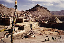
In the center of Gyangzê there was originally a mountain fortress that dates back to the 9th century. In the 14th century it was rebuilt and expanded to become the Pelkhor Chöde monastery (tib .: dpal 'khor chos sde ). The monastery is famous for its Kumbum (Tib .: sku 'bum ), the largest chorten (Tib .: mchod rten ) Tibet, which was commissioned 1440th This structure has four floors with 108 chapels and over 10,000 murals. Pelkhor Chöde Monastery is home to monks from three schools of Tibetan Buddhism : Sakya , Bodong and Gelug .
In 1904, a platform for cannons was built halfway up the fortress hill to repel British troops.

Highland barley , peas , millet and vegetables are mainly grown in Gyangzê County . It is one of the most important agricultural regions in Tibet. Gyangzê carpets are famous throughout Tibet.
Administrative division of the Gyangzê district
| Surname | Tibetan ( Wylie ) | Chinese |
|---|---|---|
| community Thraring | khra ring | 车 仁 乡 |
| Tagtse municipality | stag rtse | 达孜 乡 |
| Gyangzê municipality | rgyal rtse | 江孜 镇 |
| community Kyilkhar | dkyil mkhar | 金 嘎 乡 |
| community Caggye | lcags sgye | 加克 西乡 |
| community Cangra | lcang ra | 江 热 乡 |
| community Khangtsho | gangs mtsho | 康卓 乡 |
| Kharto municipality | mkhar stod | 卡 堆 乡 |
| community Kharme | mkhar smad | 卡麦 乡 |
| Lungmar municipality | lung dmar | 龙马 乡 |
| Naröl municipality | na rol | 纳 如 乡 |
| Nyangtö municipality | myang stod | 年 堆 乡 |
| Ralung municipality | ra lung | 热 龙乡 |
| Rasog municipality | ra so-called | 热 索 乡 |
| community Rinang | ri nang | 日 朗乡 |
| community rishing | ri zhing | 日 星 乡 |
| community Tsangkha | gtsang kha | 藏 改 乡 |
| Tsechen municipality | rtse chen | 紫金 乡 |
| Drongtse municipality | 'brong rtse | 重 孜 乡 |
Ethnic breakdown of the population of Gyangzês (2000)
In the 2000 census, Gyangzê had 61,431 inhabitants.
| Name of the people | Residents | proportion of |
|---|---|---|
| Tibetans | 60,523 | 98.52% |
| Han | 752 | 1.22% |
| Hui | 88 | 0.14% |
| Uighurs | 19th | 0.03% |
| Mongols | 17th | 0.03% |
| Dongxiang | 10 | 0.02% |
| Others | 22nd | 0.04% |
See also
literature
- F. Ricca, E. Lo Bue: The Great Stupa of Gyantse. A Complete Tibetan Pantheon of the 15th Century. London 1993.
- G. Tucci: Tibetan Painted Scrolls. Rome 1949.
Web links
Coordinates: 28 ° 54 ' N , 89 ° 38' E


