
Zhongba
| Tibetan name |
|---|
|
Tibetan script :
འབྲོང་ པ་ རྫོང །
|
|
Wylie transliteration : 'brong pa rdzong
|
|
Official transcription of the PRCh : Zhongba
|
|
THDL transcription : Drongpa
|
| Chinese name |
|
Simplified :
仲巴 县
|
|
Pinyin : Zhòngbā Xiàn
|
.png)
The county Zhongba ( Tibetan : འབྲོང་ པ་ རྫོང་ , Wylie transliteration : 'brong pa rdzong even Drongpa Dzong ) is in the northwest of the prefecture-level city Shigatse in Tibet Autonomous Region of the People's Republic of China . It has an area of 43,594 km² and 19,493 inhabitants (at the end of 2007).
Zhongba roughly covers the area of the Zhadün ( 扎 东 ) district, which existed until around 1960 . The main town of the same name is now a small collection of z. Some of the abandoned houses and the Zhadün ( 扎 东 寺 ) monastery , in the administrative area of Tangxi village ( 唐西 村 ) in Labranggosa municipality .
The seat of the district government of Zhongbas, the municipality of Labranggosa, consists of administrative buildings, quarters of the People's Liberation Army , a large school for the children of the nomads belonging to the district, shops and some hotels, which are frequented in particular by travelers to or from Ngari .
Administrative structure
At the community level, the district consists of one large community and twelve communities . These are (official spelling / Chinese):
- Greater community Paryang ( 帕羊镇 );
- Labranggosa Parish ( 拉 让 乡 ), seat of the county government;
- Bodoi municipality 布 多 乡
- Municipality of Gêla 吉拉 乡
- Community Gyema 吉玛乡
- Horba municipality 霍尔巴 乡
- Community Lunggar 隆嘎尔乡
- Nagqu Parish 纳 久 乡
- Community Painqi 偏吉乡
- Parish of Parma 帕玛 乡
- Community Qonkor 琼果乡
- Ringtor municipality 仁 多 乡
- Community Yagra 亚热乡
gallery

Shops in Zhongba.

Welcome to the new district leader (2nd from left).

Parade of soldiers of the People's Liberation Army.
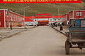
Administration building, shops and restaurants in Zhongba
_Shigatse_District_Chinese_Shops_Dieter_Schuh.JPG)
_Shigatse_District_(Tibet)_Neuer_Bezirksvorsteher._Dieter_Schuh.JPG)
_Chinese_Armee_Dieter_Schuh.JPG)

literature
- Karl-Heinz Everding: Tibet. Lamaistic monastery culture, nomadic ways of life and everyday rural life on the roof of the world . Dumont Reise Verlag, Ostfildern 2009, ISBN 978-3-7701-4803-5 .
Footnotes
- ↑ a b Guójiā cèhuìjú dìmíng yánjiūsuǒ 国家 测绘 局 地名 研究所 (ed.): Zhōngguó dìmínglù - Zhōnghuá rénmín gònghéguó dìtújí suǒyǐn 《中国 地 名录 —— 》中华人民共和国 地图集 索引 索引 ——》 . Zhōngguó dìtúchū bǎnshè 中国 地图 出版社 , Beijing 1997, p. 297.
- ↑ http://www.people.fas.harvard.edu/~chgis/work/downloads/faqs/1999_pop_faq.html
Coordinates: 29 ° 46 ' N , 84 ° 2' E