
Saga (xigazê)
| Tibetan name |
|---|
|
Tibetan script :
ས་ དགའ་ རྫོང་
|
|
Wylie transliteration : sa dga´ rdzong
|
|
Official transcription of the PRCh : Saga Dzong
|
| Chinese name |
|
Simplified :
萨嘎 县
|
|
Pinyin : Sàgà Xiàn
|
.png)
_in_Western-Tibet_Dieter_Schuh.JPG)
Saga is a district in the southwest of the prefecture-level city of Xigazê in the Tibet Autonomous Region of the People's Republic of China , which had a population of 11,414 in 1999.
Administrative structure
At the community level, the district consists of one large community and seven communities . These are (pinyin / chin.):
- Greater community Jiajia加加镇
- Changguo Township 昌 果 乡
- Community Xiongru雄如乡
- Community Lazang拉藏乡
- Community Rujiao如角乡
- Community Dajiling达吉岭乡
- Danga parish 旦 嘎 乡
- Community Xiaru夏如乡
history
The main town of the same name, the large community of Saga, was the main town of the then district and the seat of two "district leaders" (Tib. Rdzong dpon ) even before 1960 .
The first foreigners to visit this place were the Indian Nain Singh (1865) and the English CG Ryder and Cecil Rawling (1904). Even Sven Hedin visited this place. According to Rawling, the place consisted of about 25 mud houses in 1904. As it is today, it was located on the important connection route to Ngari and was one of the main stations on this route for changing transport horses (Tib .: rta zam).
Today's meaning
Today Saga is an important garrison town of the People's Liberation Army . Saga consists of numerous military barracks, administration buildings, a shopping street and several hotels that are frequented by travelers to Ngari .
gallery
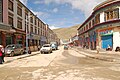
Commercial street in Saga Municipality.

Shops in Saga.

Quarters of the People's Liberation Army (left).
_Gesch%C3%A4ftsstrasse_Dieter_Schuh.JPG)
_Dieter_Schuh.JPG)

literature
- CG Rawling: The Great Plateau. Being an Account of the Exploration in Central Tibet, 1903, and of the Gartok Expedition, 1904-1905 . London 1905.
- Sven Hedin: Transhimalaya. Discoveries and adventures in Tibet . Leipzig 1909.
Footnotes
Coordinates: 29 ° 20 ' N , 85 ° 14' E