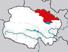
Haibei
| Tibetan name |
|---|
|
Tibetan script :
མཚོ་ བྱང་ བོད་ རིགས་ རང་སྐྱོང་ ཁུལ །
|
|
Wylie transliteration : mtsho byang bod rigs rang skyong khul
|
| Chinese name |
|
Simplified :
海北 藏族 自治州
|
|
Pinyin : Hǎiběi Zàngzú Zìzhìzhōu
|
The Tibetan Autonomous District Haibei ( Chinese 海北 藏族 自治州 , Pinyin Hǎiběi Zàngzú Zìzhìzhōu ; Tibetan མཚོ་ བྱང་ བོད་ རིགས་ རང་སྐྱོང་ ཁུལ་ mtsho-byang bod-rigs rang-skyong-khul ) is located in the northeast of the Chinese province Qinghai and is part of the Tibetan cultural region Amdo . The Tibetan name is Tshojang. Its administrative seat is the large community of Xihai (西海 镇Xihai zhen ) in Haiyan County, a small town that has developed from the former nuclear research institute, which operated under the name "Ninth Academy" in the west (closed in 1987). Haibei has an area of 39,354 km² and approx. 281,200 inhabitants (2016). The autonomous district is subordinate to three districts and one autonomous district:
- Haiyan district (海晏 县), main town: Sanjiaocheng (三角 城镇), 4,348 km², approx. 30,000 inhabitants;
- Qilian district (祁连 县), capital: Babao municipality (八宝 镇), 15,610 km², approx. 50,000 inhabitants;
- Gangca district (刚察 县), capital: Shaliuhe municipality (沙柳 河镇), 12,500 km², approx. 40,000 inhabitants;
- Menyuan Hui Autonomous County (门 源 回族 自治县), capital: Haomen municipality (浩 门 镇), 6,896 km², approx. 150,000 inhabitants.
Ethnic breakdown of the population (2000)
In the 2000 census, Haibei had 258,922 inhabitants (population density: 6.58 inh / km²).
| Name of the people | Residents | proportion of |
|---|---|---|
| Han | 94,841 | 36.63% |
| Hui | 79,190 | 30.58% |
| Tibetans | 62,520 | 24.15% |
| Mongols | 13,087 | 5.05% |
| Do | 7,806 | 3.01% |
| Salar | 901 | 0.35% |
| Others | 577 | 0.23% |
See also
Coordinates: 37 ° 39 ' N , 100 ° 27' E
