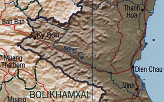
Ca (river)
| Sông Cả / Sông Lam | ||
| Data | ||
| location | Laos , Vietnam | |
| River system | Approx | |
| source | Laos, Loi Mountains 19 ° 27 ′ 0 ″ N , 103 ° 39 ′ 0 ″ E |
|
| muzzle | Vietnam, South China Sea Coordinates: 18 ° 45 ′ 36 " N , 105 ° 45 ′ 36" E 18 ° 45 ′ 36 " N , 105 ° 45 ′ 36" E |
|
| Mouth height |
0 m
|
|
| length | 512 km | |
| Catchment area | 27,200 km² | |
The Ca (Vietnamese Sông Cả , also called Ngàn Cả or Sông Lam ) is a 512 km long river in Southeast Asia . It rises in the Loi Mountains in northern Laos and flows through the province of Nghệ An in northern Vietnam before flowing into the South China Sea near the city of Vinh . The valley of the Ca is considered to be one of the cradles of Vietnamese culture and was already settled in the Paleolithic .
Web links
Commons : Ca (river) - collection of images, videos and audio files
