Đồng Hới
| Đồng Hới | ||
|---|---|---|
|
|
||
| Basic data | ||
| Country: |
|
|
| Region: | Central Vietnam | |
| Region : | Northern coastal region Bắc Trung Bộ |
|
| Province : | Quảng Bình | |
| ISO 3166-2: VN : | VN-24 | |
| Coordinates : | 17 ° 29 ′ N , 106 ° 36 ′ E | |
| Height : | 19 m | |
| City area: | 154.55 km² | |
| Waters : |
Nhật Lệ river, Bau Tró lake |
|
| population | ||
| City residents : | 103,988 (2006) | |
| Ethnic groups : | Kinh | |
| Further information | ||
| Full name: | Thành Phố Đồng Hới | |
| Name meaning: | City within the sea | |
| Founding: | 2004 (city) | |
| Area code : | +84 (0) 52 | |
| Vehicle registration number : | 73 | |
| Time zone : | UTC +7: 00 | |
| administration | ||
| City structure: | 10 phường and 6 xã | |
| Website: | www.donghoi.gov.vn | |

Dong Hoi (Vietnamese Đồng Hới ) is the capital of the province of Quảng Bình in central Vietnam . It is about 500 km south of Hanoi , 260 km north of Da Nang and 1200 km north of Ho Chi Minh City , 50 km south of Phong Nha-Ke Bang National Park , a UNESCO World Heritage Site . The city is located at the narrowest point in Vietnam, which is only 40 km from the sea to the western border. 130,000 people live in Dong Hoi (2005), the city area is 154.54 square kilometers. The province lies between Laos in the west and the South China Sea in the east. To the north the district Bố Trch and in the south the district Quảng Ninh borders on the province Quảng Bình .
City structure
Dong Hoi is divided into 10 phường and 6 xã .
| No. | Surname | Vietnamese | Residents | Area in km² |
|---|---|---|---|---|
| 1. | Bac Ly | Phường Bắc Lý | 13,536 | 10.19 |
| 2. | Bac Nghia | Phường Bắc Nghĩa | 6981 | 7.76 |
| 3. | Dong My | Phường Đồng Mỹ | 2653 | 0.58 |
| 4th | Dong Phu | Phường Đồng Phú | 8016 | 3.81 |
| 5. | Dong Son | Phường Đồng Sơn | 8815 | 19.65 |
| 6th | Duc Ninh Dong | Phường Đức Ninh Đông | 4726 | 3.13 |
| 7th | Hai Dinh | Phường Hải Đình | 3808 | 8,822 |
| 8th. | Hai Thanh | Phường Hải Thành | 4774 | 2.45 |
| 9. | Nam Ly | Phường Nam Lý | 11,579 | 3.9 |
| 10. | Phu Hai | Phường Phu Hải | 3440 | 3.06 |
| 11. | Bao Ninh | Xã Bảo Ninh | 8538 | 16.3 |
| 12. | Duc Ninh | Xã Đức Ninh | 7526 | 5.21 |
| 13. | Loc Ninh | Xã Lộc Ninh | 8407 | 13.4 |
| 14th | Nghia Ninh | Xã Nghĩa Ninh | 4508 | 16.22 |
| 15th | Quang Phu | Xã Quang Phu | 3106 | 3.23 |
| 16. | Thuan Duc | Xã Thuận Đức | 3738 | 45.28 |
tourism
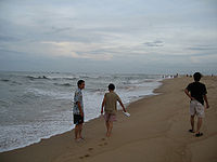
Dong Hoi is known for its fine sandy beach. 50km north of the city lies the National Park Phong Nha-Ke Bang , which the World Heritage of UNESCO counts, and is operated in the well caving. Dong Hoi can be reached by the National Highway 1A, ("Ho Chi Minh Highway",) and by rail via the Hanoi Line from Ho Chi Minh City. It also has an airport. There are several hotels of different categories there.
Industrial development
There is a deep-sea shipping port called Hon La Hafen (Vietnamese: Cảng Hòn La ) that can accommodate ships of up to 50,000 gross tons . There are also two industrial areas.
history
The location of what is now Dong Hoi has long been disputed between the Champa Empire and the Dai Viet in history. It officially became Dai Viet territory when a princess of Tran Huyen married into the Dai Viet family. During the Wars of Trinh and Nguyen (1588–1775), Vietnam was divided into two parts: Dang Trong in the south and Dang Ngoai in the north. Hoi became an important border fortress of the southern empire. The Dong Hoi Wall (Vietnamese: Thành Đồng Hới) was built as a protective wall against attacks by the northern rulers. During the Indochina War , Hoi was used as a base for the French air forces. During the Vietnam War , the city was badly destroyed by American B-52 bombers. In 1990, Binh Tri Thien Province was divided into three provinces, and Dong Hoi became the capital of Quang Binh Province.

