
Fatuhada
| Fatuhada | |||

|
|||

|
|||
| Data | |||
| surface | 1.24 km² | ||
| population | 14,890 (2015) | ||
| Chefe de Suco | Marcelino Soares (election 2016) |
||
| Aldeias | Population (2015) | ||
| Zero I. | 2,276 | ||
| Zero II | 2,503 | ||
| Zero III | 5,895 | ||
| Zero IV | 2,181 | ||
| Zero V | 2,035 | ||
|
|||

Fatuhada (formerly Beira Mar ) is an East Timorese Suco in the administrative office of Dom Aleixo ( municipality of Dili ) and district of the state capital Dilis .
The district
Fatuhada is located in the south-eastern center of Sucos. The district is located at 0 m above sea level . The primary school Escola Primaria No. is located here . 6 Fatuhada .
The Suco
| Fatuhada | ||
| places | position | height |
| Bedik | 8 ° 33 ' S , 125 ° 33' E | 0 m |
| Fatuhada | 8 ° 33 ' S , 125 ° 33' E | 0 m |
| Markoni | 8 ° 33 ' S , 125 ° 33' E | 0 m |
| Mataruak | 8 ° 33 ' S , 125 ° 33' E | 0 m |

|

|
|
|
Dancers in costume in Fatuhada
|
||
14,890 inhabitants (2015) live in Fatuhada, of whom 7,669 are men and 7,221 women. The population density is 12,003.7 inhabitants / km². There are 2,407 households in the Suco. 93% of the population name Tetum Prasa as their mother tongue. Minorities speak Rahesuk , Naueti , Makasae , Sa'ani , Makalero , Fataluku or Baikeno .
Before the 2015 territorial reform, Fatuhada had an area of 0.81 km². Now it is 1.24 km². The Suco is in the northeast of the Dom Aleixo Administrative Office, on the banks of the Wetar Strait . To the east lies the Suco Kampung Alor , south Bairro Pite and west Comoro .
In the north-west lies the Mataruak district , in the west Makoni , in the south-west Bedik and in the south-east Fatuhada . The new State Department is in Fatuhada and the United States Embassy is here. In addition to the primary school in Fatuhada, there is the Escola Pre-Secondario No. 2 Comoro and a secondary school. The Hilton Palm Spring Estate is currently being built on Rua de Manu Tafui (2018). The private QSI International School of Dili is also located here.
In Suco are the five Aldeias Zero I , Zero II , Zero III , Zero IV and Zero V .
politics
In the elections of 2004/2005 was Justino Leite MG elected Chefe de Suco. In the 2009 elections , Marcelino Soares won and the 2016 elections were confirmed.
gallery

Aerial view of Fatuhada.
The free space on the right is part of the United States Embassy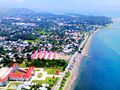
Aerial view of Fatuhada.
The State Department below
Hotel Esplanada

QSI International School and shell of the Hilton Palm Spring Estate on Rua de Manu Tafui (2018)

Private house on Beco Ai-Kameli Tahan street , built around 2012


Web links
- Results of the 2010 census for the Suco Fatuhada ( tetum ; PDF; 8.1 MB)
- Results of the 2015 census for the Suco Fatuhada (tetum; PDF)
- Seeds of Life: Suco information sheets Dom Aleixo (tetum)
Individual evidence
- ↑ a b c d Direcção-Geral de Estatística : Results of the 2015 census , accessed on November 23, 2016.
- ↑ Timor-Leste: Poverty in a Young Nation ( Memento from December 25, 2010 in the Internet Archive ) (PDF; 1.2 MB)
- ↑ a b List of polling stations for the parliamentary elections in East Timor 2007 (PDF file; 118 kB)
- ↑ Fallingrain.com: Directory of Cities, Towns, and Regions in East Timor
- ↑ Results of the 2010 census for the Suco Fatuhada ( tetum ; PDF; 8.1 MB)
- ↑ Direcção Nacional de Estatística: Population Distribution by Administrative Areas Volume 2 English ( Memento from January 5, 2017 in the Internet Archive ) (Census 2010; PDF; 22.6 MB)
- ^ Timor-Leste GIS-Portal ( Memento from June 30, 2007 in the Internet Archive )
- ↑ UNMIT: Timor-Leste District Atlas version 02, August 2008 ( Memento from March 4, 2016 in the Internet Archive ) (PDF file; 583 kB)
- ↑ Jornal da Républica with the Diploma Ministerial n. 199/09 ( Memento of February 3, 2010 in the Internet Archive ) (Portuguese; PDF; 323 kB)
- ↑ Secretariado Técnico de Administração Eleitoral STAE: Eleições para Liderança Comunitária 2004/2005 - Resultados ( Memento of August 4, 2010 in the Internet Archive )
- ↑ Secretariado Técnico de Administração Eleitoral STAE: Eleições para Liderança Comunitária 2009 - Resultados ( Memento of August 4, 2010 in the Internet Archive )
- ↑ GMN TV: Xefe Suku Fatuhada Lamenta ho Sistema husi Ministerio Administração Estatal , May 2, 2020 , accessed on June 11, 2020.
Bairro Pite | Bebonuk | Comoro | Fatuhada | Kampung Alor | Madohi | Manleuana
![]() Map with all coordinates: OSM | WikiMap
Map with all coordinates: OSM | WikiMap
The administrative borders within East Timor changed in 2015. This article must therefore be checked and updated if necessary. See New Administrative Boundaries .