
Avenida Nicolau Lobato
| Avenida Nicolau Lobato | |
|---|---|
| Street in Dili | |
 |
|
| Avenida Nicolau Lobato | |
| Basic data | |
| place | Dili |
| District | Motael , Colmera , Kampung Alor , Fatuhada |
| Hist. Names | Eastern part: Avenida Almirante Américo Tomás , Avenida / Rua dos Direitos Humanos (until 2015); Western part: Avenida Presidente Nicolau Lobato |
| Connecting roads | Avenida Marginal , Avenida da Restauração |
| Cross streets | Rua Beto Oeste , Rua de Malinamok , Rua Luro Mata |
| Places | Jardim 5 de Maio |
| Buildings | Hotel Timor , Main Customs Office, East Timor’s Presidential Palace , Embassy of Australia , East Timor’s Ministry of Defense & East Timor’s Defense Forces Headquarters, FRETILIN Central Committee, Aimutin Church, Timor Plaza , Police Academy, Arte Moris |
| use | |
| User groups | Pedestrian traffic , private traffic , public transport |
| Technical specifications | |
| Street length | about 5.4 km |
The Avenida Nicolau Lobato is the main arterial road of the East Timorese capital Dili to the west, with a length of about 5.4 kilometers. It is named after the former president and independence fighter Nicolau dos Reis Lobato . The southern Rua Nicolau dos Reis Lobato in Colmera , formerly Rua José Maria Marques , has been called Rua 25 de Abril since 2015 .
course
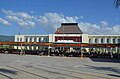
The Avenida Nicolau Lobato starts in the center of Dili as an extension of Avenida Marginal , away from the Bay of Dili and the government district. On the north side is the Suco Motael , on the south side of the Suco Colmera. Both belong to the Vera Cruz Administration Office . Right at the beginning, on the north side, there is the monument to Manuel Jesus Pires and the Jardim 5 de Maio city park with the integration monument. The seat of government of the Portuguese governor used to be located here, but it was rebuilt further east after its destruction in World War II . The Hotel Timor and the main customs office are on the south side . The Avenida Mártires da Pátria and the Rua da Catedral , after which the south side of the Avenida Nicolau Lobato also belongs to Motael , lead to the south . On the corner of Rua Ribeira de Maloa , the Jardim Infantil park has been created with a fountain and a memorial depicting two people with the East Timor flag.
After the Maloa River , Avenida Nicolau Lobato leads through the Dom Aleixo administrative office with the Sucos Kampung Alor and Fatuhada in the north and the Suco Bairro Pite in the south. There is also the East Timorese Presidential Palace on the road and the Australian Embassy to the west on the north side . Up to the border of Kampung Alor and Fatuhada, the street originally had the name Avenida Alm. Américo Tomás , named after the Portuguese admiral and President Américo Tomás (1894–1987). With the end of the Indonesian occupation, the street was called Avenida or Rua dos Direitos Humanos until 2015 . To the west, the street was called Avenida Presidente Nicolau Lobato until 2015 . Further west on the south side is the Ministry of Defense with the headquarters of the Defense Forces of East Timor (F-FDTL), on the north side the building of the Central Committee of FRETILIN and later again on the south side the Aimutin church and on the north side, after Rua Luro Mata , the Timor Plaza , East Timor's first and largest shopping mall.
After the bridge over the Rio Comoro , Avenida Nicolau Lobato leads through the Suco Comoro . On the north side is first the Academy of the National Police of East Timor (PNTL), then a little away from the street the house of the art school, cultural center and artist association Arte Moris . Finally, Avenida Nicolau Lobato ends at the Rotunda Nicolau Lobato roundabout , with a statue of the President in its center. Westward leading Avenida da Restauração on, from the north coming from the airport Presidente Nicolau Lobato ago the Rua Beto Oeste and from the south, the Rua de Malinamok .
gallery

Integration monument in Jardim 5 de Maio
Presidential palace

Outer wall of the Embassy of Australia

Timor Plaza

Arte Moris

Roundabout Nicolau Lobato

Park on the corner of Rua Ribeira da Maloa

Fountain in the park


Individual evidence
Coordinates: 8 ° 33 ′ 14.9 ″ S , 125 ° 32 ′ 54.6 ″ E