Colmera
| Colmera | ||

|
||

|
||
| Data | ||
| surface | 0.37 km² | |
| population | 2,117 (2015) | |
| Chefe de Suco | Armenio Aleixo da Silva (election 2009) |
|
| Aldeias | Population (2015) | |
| Manu Fuic | 1,512 | |
| Rai Nain | 605 | |
|
|
||
Colmera (formerly 28 Novembro ) is an East Timorese Suco in the administrative office of Vera Cruz ( municipality of Dili ) and part of the state capital Dili . Until 2004 Colmera was part of the Dom Aleixo administrative office . The Suco forms the urban center of Dilis and the political center of the state capital.
The district
The district of Colmera forms the south of the Sucos, at an altitude of 11 m . The Ministry of State Administration and the Ministry of Justice are located here.
The Suco
| Colmera | ||
| places | position | height |
| Colmera | 8 ° 33 ' S , 125 ° 34' E | 11 m |
| Soslodade | 8 ° 33 ' S , 125 ° 34' E | 11 m |
Colmera has 2,117 inhabitants (2015), of which 1158 are men and 959 women. The population density is 5755.2 inhabitants / km². There are 378 households in the Suco. Over 83% of the population name Tetum Prasa as their mother tongue. Minorities speak Kemak , Makasae , Tetum Terik , Fataluku , Mambai , Isní or Idaté .
The Suco borders the Suco Motael in the north and west and the Sucos Caicoli and Vila Verde in the south . In the east is the administrative office of Nain Feto with the sucos Bidau Lecidere and Gricenfor . The west of Colmera forms the east of the district of Bairo Alto , the north Soslodade and the south Colmera .
Before the 2015 regional reform, Colmera had an area of 0.58 km². Now it is 0.37 km². The west of Bairo Alto, between the Maloa river and the Rua da Catedral, was given to Motael, as was the thin strip of land north of Avenida Marginal . The block between Avenida 20 de Maio in the south, Avenida Xavier do Amaral in the east, Rua Formosa in the north and Rua da Moçambique in the west went to Suco Caicoli.
The Rio Colmera used to flow to the west of the Sucos and flowed into the Bay of Dili to the west of Jardim 5 de Maio .
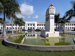
In the center and core of Dilis is the government palace , the national parliament and the Universidade Nasionál Timór Lorosa'e (UNTL). The Tais market and the Comissão Nacional de Eleições (CNE) building are in Bairo Alto, and the Ministry of Planning and Finance is in Soslodade. In addition, Colmera is the seat of the East Timor Public Prosecutor's Office .
The two Aldeias Manu Fuic and Rai Nain are located in the Suco .
politics
In the 2004/2005 elections , Ricardo Guterres was elected Chefe de Suco. In the 2009 elections , Armenio Aleixo da Silva won .
See also
Web links
- Results of the 2010 census for the Suco Colmera ( tetum ; PDF; 8.1 MB)
- Results of the 2015 census for the Suco Colmera (tetum; PDF)
- Seeds of Life: Suco information sheets Vera Cruz (tetum)
Individual evidence
- ↑ a b c d Direcção-Geral de Estatística : Results of the 2015 census , accessed on November 23, 2016.
- ↑ Timor-Leste: Poverty in a Young Nation ( Memento from December 25, 2010 in the Internet Archive ) (PDF; 1.2 MB)
- ↑ a b City map of Dili ( Memento from June 30, 2007 in the Internet Archive ) (PDF; 1.3 MB)
- ↑ Fallingrain.com: Directory of Cities, Towns, and Regions in East Timor
- ↑ Results of the 2010 census for the Suco Colmera ( tetum ; PDF; 8.1 MB)
- ^ Timor-Leste GIS-Portal ( Memento from June 30, 2007 in the Internet Archive )
- ↑ Direcção Nacional de Estatística: Population Distribution by Administrative Areas Volume 2 English ( Memento of the original from January 5, 2017 in the Internet Archive ) Info: The archive link has been inserted automatically and has not yet been checked. Please check the original and archive link according to the instructions and then remove this notice. (2010 census; PDF; 22.6 MB)
- ↑ Ministry of State Administration and Territorial Management : Map of the Vera Cruz Administration Office ( Memento of the original from January 10, 2017 in the Internet Archive ) Info: The archive link was inserted automatically and has not yet been checked. Please check the original and archive link according to the instructions and then remove this notice. , accessed April 1, 2017.
- ↑ Architectural Heritage of Portuguese Origin , map on p. 16 , accessed June 3, 2016.
- ↑ Timor-Leste District Atlas version 02, August 2008 ( Memento of the original dated December 3, 2011 in the Internet Archive ) Info: The archive link was inserted automatically and has not yet been checked. Please check the original and archive link according to the instructions and then remove this notice. (PDF; 448 kB)
- ↑ Jornal da Républica with the Diploma Ministerial n. 199/09 ( Memento of February 3, 2010 in the Internet Archive ) (Portuguese; PDF; 323 kB)
- ↑ Secretariado Técnico de Administração Eleitoral STAE: Eleições para Liderança Comunitária 2004/2005 - Resultados ( Memento of August 4, 2010 in the Internet Archive )
- ↑ Secretariado Técnico de Administração Eleitoral STAE: Eleições para Liderança Comunitária 2009 - Resultados ( Memento of August 4, 2010 in the Internet Archive )


