Rio Comoro
| Rio Comoro | ||
|
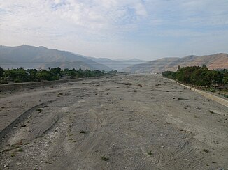
Rio Comoro in the dry season in the municipality of Dili |
||
| Data | ||
| location | East Timor | |
| River system | Rio Comoro | |
| Drain over | Strait of Ombai → Pacific Ocean | |
| origin | Confluence of Mata Hare and Balele | |
| muzzle | in the Strait of Ombai Coordinates: 8 ° 32 ′ 17 ″ S , 125 ° 32 ′ 4 ″ E 8 ° 32 ′ 17 ″ S , 125 ° 32 ′ 4 ″ E
|
|
| Right tributaries | Bemos , Beinas | |
| Big cities | Dili | |
| Communities | Leorema | |
| periodic flow (only water-bearing in the rainy season) | ||
The Rio Comoro ( Comoro River , Ribeira de Comoro ) is a mostly dry river in East Timor that only carries water during the rainy season. The locals use the river sand as a building material.
Source rivers, tributaries and course

The Pahiklan rises in Suco Leorema ( municipality of Liquiçá ) and shortly thereafter changes its name to Ermela . As Anggou it flows east and forms the border between Liquiçá and the municipality of Ermera . The Buamara rises in Suco Railaco Leten (municipality of Ermera) and flows northwest. After his turn to the northeast he is called Baera . After the meeting of Anggou and Baera , the river is called Mata Hare . The Balele rises in the border area of the Sucos Railaco Leten, Railaco Craic and Taraco (all in the municipality of Ermera) and then flows to the northwest. Together with the Mata Hare, it forms the Rio Comoro and the border between Liquiçá and Ermera, or Liquiçá and the municipality of Aileu . Here, about half an hour's drive south of the state capital Dili , the Rio Comoro in Suco Fatisi plunges several meters down the Berloi waterfall . Finally the Comoro swings north into the Suco Comoro ( municipality of Dili ).
The Bemos , later called Rio Beinas, has its source in Suco Talitu (municipality of Aileu) . After it has swung into the municipality of Dili, it flows in close proximity parallel to the Rio Comoro through the Suco Comoro. Shortly before the coast, the Beinas finally flows into the Rio Comoro. During the rainy season, both rivers swell strongly and merge much earlier to form a broad stream. In the dry season the water supply from the mountains dries up and only a wide bed of gravel remains. The Rio Comoro flows east of the Presidente Nicolau Lobato airport into the Strait of Ombai .
- Mouth of the Comoros
Web links
Individual evidence
- ↑ Isabel Nolasco Photography: Waterfalls , accessed March 20, 2016.


