Bemos
|
Bemos Rio Bemos, Beinas (lower reaches) |
||
|
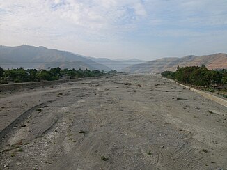
Dried up riverbed of Bemos and Comoro |
||
| Data | ||
| location | East Timor | |
| River system | Rio Comoro | |
| Drain over | Rio Comoro → Strait of Ombai → Pacific Ocean | |
| source | south of Talitu 8 ° 37 ′ 6 ″ S , 125 ° 36 ′ 53 ″ E |
|
| Source height | approx. 720 m | |
| muzzle | in Mate Lahotu in the Rio Comoro coordinates: 8 ° 32 ′ 33 ″ S , 125 ° 32 ′ 8 ″ E 8 ° 32 ′ 33 ″ S , 125 ° 32 ′ 8 ″ E |
|
| Mouth height | 102 m | |
| Height difference | approx. 618 m
|
|
| Big cities | Dili | |
| Small towns | Dare | |
| Communities | Talitu , Cotolau , Madabeno , Tohumeta , Faitsi | |
| intermittent river, common river bed with Rio Comoro begins southwest of Casnafar | ||
The Bemos is a right tributary of the Rio Comoro in East Timor .
Source rivers, tributaries and course

The Bemos rises south of the town of Talitu in the Suco of the same name ( Laulara administrative office , Aileu municipality ) at an altitude of about 720 m in the forest.
The river meanders strongly through the Suco Cotolau and, flowing westwards, soon forms part of the border between the municipality of Aileu (Suco Madabeno and Tohumeta ) and the municipality of Dili (Suco Dare ). The bemos flows partly exactly on the border, partly the border is sometimes a little to the right and sometimes to the left of the river. After it has swung north into the municipality of Dili, it flows in close proximity parallel to the Rio Comoro through the Suco Comoro . Here in the lower reaches the name changes to Beinas . In the rainy season, the two rivers even form a common bed, outside both rivers dry up, so that only the common, dried out gravel bed remains.
The common course of the river begins a little southwest of Casnafar . The exact course of the two rivers can hardly be clearly distinguished from one another in the common river bed. Shortly before the coast, the Beinas finally flows into the Rio Comoro near Mate Lahotu , the district of Dili.
