Irabin de Baixo
| Irabin de Baixo | ||

|
||

|
||
| Data | ||
| surface | 23.86 km² | |
| population | 2,596 (2015) | |
| Chefe de Suco | Marcal do Santos Carvalho (election 2009) |
|
| Aldeias | Population (2015) | |
| Beturia | 416 | |
| Lacoloro Ho'o | 459 | |
| Macaqui | 349 | |
| Macausa | 375 | |
| Taradai | 361 | |
| Taradiga | 244 | |
| Uatodere | 392 | |
|
|
||
Irabin de Baixo ( Iarabin de Baixu , Ira Bin Craic , Irabin Kraik ; naueti : Irabin Leterea ; German "Unter-Irabin" ) is an East Timorese Suco in the administrative office of Uatucarbau ( municipality of Viqueque ).
geography
| Irabin de Baixo | ||
| places | position | height |
| Beturia | 8 ° 45 ′ S , 126 ° 42 ′ E | 27 m |
| Bualale | 8 ° 44 ' S , 126 ° 43' E | 77 m |
| Cailorodi | 8 ° 45 ′ S , 126 ° 42 ′ E | 27 m |
| Irabin Leteria | 8 ° 45 ′ S , 126 ° 42 ′ E | 27 m |
| Lacoloro Ho'o | 8 ° 43 ' S , 126 ° 41' E | 212 m |
| Maraussa | 8 ° 45 ' S , 126 ° 43' E | 25 m |
| Maussoe | 8 ° 43 ' S , 126 ° 40' E | 296 m |
| Taradai | 8 ° 45 ′ S , 126 ° 42 ′ E | 27 m |
| Taradiga | 8 ° 45 ' S , 126 ° 43' E | 47 m |
| Uagabuta | 8 ° 42 ' S , 126 ° 42' E | 190 m |
| Uatodere | 8 ° 45 ′ S , 126 ° 42 ′ E | 25 m |
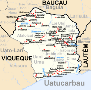
Before the 2015 territorial reform, Irabin de Baixo had an area of 24.68 km². Now there are 23.86 km². The Suco is located in the south of the Uatucarbau administrative office on the Timor Sea . To the west is the Suco Uani Uma , to the north the Sucos Afaloicai and Loi Ulo and northeast of the Suco Irabin de Cima . In the southeast, Irabin de Baixo borders the administrative office of Iliomar, which belongs to the municipality of Lautém, with its Suco Tirilolo . The Uaidori River flows through Irabin de Baixo . The river Irebere forms the border with Lautém .
The southern coastal road, one of the country's most important traffic routes, runs through the south. Due to it Uatucarbau , the administrative center of the Office of Administration, which comprises several districts. These are Irabin Letere ( Irabin Letarea ), Taradai ( Taradae ), Beturia ( Betoria ), Maraussa ( Maka Ussa ), Uatodere and Cailorodi . Taradiga is located further to the east . From here an overland road branches off the coastal road to the north. To the northwest of Irabin de Baixo are the villages of Lacoloro Ho'o ( Lacoloro Hoo , Lacoloroho ), Maussoe and Uagabuta . Bualale is located on the Uaidori River on the border with Irabin de Cima . Uatucarbau has two primary schools (one of which is Escola Primaria Irabin ), a pre-secondary school, a community health center, a police station and a helipad.
In the Suco there are the seven Aldeias Beturia , Lacoloro Ho'o , Macaqui , Macausa , Taradai , Taradiga and Uatodere .
Residents

The Suco has 2596 inhabitants (2015), of which 1272 are men and 1324 women. The population density is 108.8 inhabitants / km². There are 463 households in the Suco. Almost 95% of the population name Naueti as their mother tongue. Almost 3% speak Tetum Prasa , small minorities speak Tetum Terik or Makasae .
history
When the Indonesians occupied the region, houses and fields in Irabin Leteria were burned down and livestock were killed. At the end of 1979 there was an Indonesian camp here for East Timorese who were supposed to be relocated by the occupiers for better control.
politics
In the elections of 2004/2005 was Marcal do Santos Carvalho elected Chefe de Suco and in 2009 re-elected.
Web links
- Results of the 2010 census for the Suco Irabin de Baixo ( tetum ; PDF; 8.4 MB)
- Results of the 2015 census for the Suco Irabin de Baixo (tetum; PDF)
- Seeds of Life: Suco information sheets Uatucarbau (tetum)
Individual evidence
- ↑ a b c d Direcção-Geral de Estatística : Results of the 2015 census , accessed on November 23, 2016.
- ↑ Fallingrain.com: Directory of Cities, Towns, and Regions in East Timor
- ↑ Direcção Nacional de Estatística: Population Distribution by Administrative Areas Volume 2 English ( Memento from January 5, 2017 in the Internet Archive ) (Census 2010; PDF; 22.6 MB)
- ^ Timor-Leste GIS-Portal ( Memento from June 30, 2007 in the Internet Archive )
- ↑ List of polling stations for the parliamentary elections in East Timor 2007 (PDF file; 118 kB)
- ↑ UNMIT: Timor-Leste District Atlas version 02, August 2008 ( Memento from December 3, 2011 in the Internet Archive ) (PDF; 509 kB)
- ↑ Jornal da República: Diploma Ministerial n ° 16/2017 , with corrections dated May 9, 2017 , accessed on March 12, 2019.
- ↑ Results of the 2010 census for the Suco Irabin de Baixo ( tetum ; PDF; 8.4 MB)
- ↑ "Chapter 7.3 Forced Displacement and Famine" (PDF; 1.3 MB) from the "Chega!" Report of the CAVR (English)
- ↑ Secretariado Técnico de Administração Eleitoral STAE: Eleições para Liderança Comunitária 2004/2005 - Resultados ( Memento of August 4, 2010 in the Internet Archive )
- ↑ Secretariado Técnico de Administração Eleitoral STAE: Eleições para Liderança Comunitária 2009 - Resultados ( Memento of August 4, 2010 in the Internet Archive )

