Bahatata
| Bahatata | ||

|
||
| Data | ||
| surface | 22.98 km² | |
| population | 601 (2015) | |
| Chefe de Suco | Vicente Domingos Amaral (election 2009) |
|
| Aldeias | Population (2015) | |
| Builacurae | 90 | |
| Nelu-uai | 81 | |
| Tatadere | 26th | |
| Uaimare | 404 | |
|
|
||
Bahatata is an East Timorese place and Suco in the administrative office of Uatucarbau ( municipality of Viqueque ).
The place
The place Bahatata is located in the southeast of the Sucos, at an altitude of 136 m .
The Suco
| Bahatata | ||
| places | position | height |
| Bahatata | 8 ° 41 ' S , 126 ° 43' E | 136 m |
| Builako | 8 ° 41 ' S , 126 ° 43' E | 136 m |
| Nelu-uai | 8 ° 41 ' S , 126 ° 43' E | 136 m |
| Tatadere | 8 ° 41 ' S , 126 ° 43' E | 136 m |
| Utiarori | 8 ° 42 ' S , 126 ° 43' E | 136 m |
Bahatata has 601 inhabitants (2015), of which 293 are men and 308 women. The population density is 26.1 inhabitants / km². There are 134 households in the Suco. Over 68% of the population name Naueti as their mother tongue. Almost 28% speak Makasae .
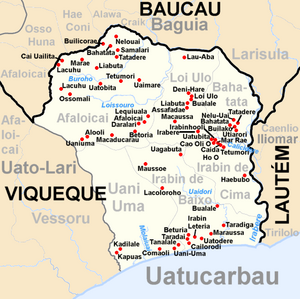
Before the 2015 territorial reform, Bahatata had an area of 11.37 km². Now there are 22.98 km². The Suco is located in the northeast of the Uatucarbau administrative office. To the west is the Suco Loi Ulo , to the south, across the Calicidere river , the Suco Irabin de Cima . The Calicidere flows into the Irebere , which delimits the Suco from the neighboring communities to the north and east. In the northeast this is the municipality of Baucau with the Suco Larisula belonging to the administrative office of Baguia . In the south-east of the municipality of Lautém is the administrative office of Iliomar with its Suco Caenlio .
The larger towns of sucos are concentrated in the south. In addition to Bahatata, Builako , Nelu-Uai ( Nelouai ), Tatadere ( Tatodere ) and Utiarori ( Utimori ).
The Suco has a primary school.
In the Suco there are the four Aldeias Builacurae , Nelu-Uai , Tatadere and Uaimare .
politics
In the elections of 2004/2005 was Vicente Domingos Amaral elected Chefe de Suco and in 2009 re-elected.
Web links
- Results of the 2010 census for the Suco Bahatata ( tetum ; PDF; 8.4 MB)
- Results of the 2015 census for the Suco Bahatata (tetum; PDF)
- Seeds of Life: Suco information sheets Uatucarbau (tetum)
Individual evidence
- ↑ a b c d Direcção-Geral de Estatística : Results of the 2015 census , accessed on November 23, 2016.
- ↑ Fallingrain.com: Directory of Cities, Towns, and Regions in East Timor
- ↑ SPECIFY results of the 2010 census for the Suco Bahatata ( tetum ; PDF; 8.4 MB)
- ↑ Direcção Nacional de Estatística: Population Distribution by Administrative Areas Volume 2 English ( Memento of the original from January 5, 2017 in the Internet Archive ) Info: The archive link has been inserted automatically and has not yet been checked. Please check the original and archive link according to the instructions and then remove this notice. (2010 census; PDF; 22.6 MB)
- ^ Timor-Leste GIS-Portal ( Memento from June 30, 2007 in the Internet Archive )
- ↑ UNMIT: Timor-Leste District Atlas version 02, August 2008 ( Memento of the original from December 3, 2011 in the Internet Archive ) Info: The archive link has been inserted automatically and has not yet been checked. Please check the original and archive link according to the instructions and then remove this notice. (PDF; 509 kB)
- ↑ Jornal da Républica with the Diploma Ministerial n. 199/09 ( Memento of February 3, 2010 in the Internet Archive ) (Portuguese; PDF; 323 kB)
- ↑ Secretariado Técnico de Administração Eleitoral STAE: Eleições para Liderança Comunitária 2004/2005 - Resultados ( Memento of August 4, 2010 in the Internet Archive )
- ↑ Secretariado Técnico de Administração Eleitoral STAE: Eleições para Liderança Comunitária 2009 - Resultados ( Memento of August 4, 2010 in the Internet Archive )
